IOOS Awards $31 Mln for Ocean Observation
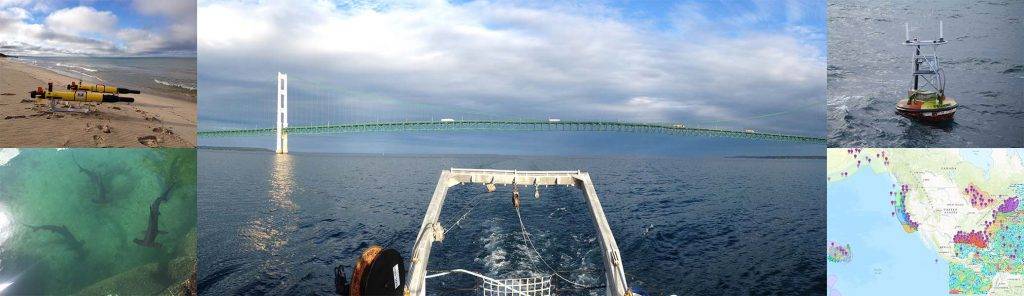
Image: IOOS
More than $31 million has been awarded in grants from the U.S. Integrated Ocean Observing System (IOOS) to support ocean, coastal and Great Lakes observing efforts throughout the United States, Caribbean and Pacific.
IOOS said the funds, which are to be distributed primarily as five-year cooperative agreements, are augmented by contributions from other federal offices and agencies, as well as outside groups including: National Oceanic and Atmospheric Administration’s (NOAA) Office Oceanic and Atmospheric Research (OAR), NOAA’s Ocean Acidification Program (OAP), the National Weather Service (NWS), NOAA Fisheries (NMFS), NOAA’s Office of Coast Survey (OCS), NOAA’s Office for Coastal Management, NOAA’s National Centers for Coastal Ocean Science (NCCOS), NOAA’s Satellite and Information Service (NESDIS), the U.S. Geological Survey (USGS), NOAA’s Great Lakes Environmental Research Laboratory (GLERL), and the IOOS Association. Some additional funding is directed through the Ocean Technology Transition (OTT) project at IOOS, which sponsors the transition of emerging technologies to operational mode.
Goals for these new agreements are wide ranging, but focus on increasing the availability and accessibility of data, and on maintaining and expanding the ocean, coastal and Great Lakes observing capabilities throughout the country.
Projects, as outlined by the IOOS, are as follows:
- The Alaska Ocean Observing System (AOOS) will continue to build its state-of-the-art Ocean Data Explorer portal adding new tools and applications for harmful algal bloom risk assessments and ocean acidification monitoring and vulnerability assessments. These efforts are steadily advancing the portal into the Data Assembly Center (DAC) for Alaska, serving as a one-stop- shop for both land and sea observations across the state. AOOS will take the lead in bringing together stakeholders to develop collaborative solutions for filling observing gaps, like increased shoreline and water level measurements along the west coast of Alaska that faces severe coastal erosion and creating stakeholder driven networks like the Alaska Ocean Acidification Network. AOOS will continue to support sea ice detection and ecosystem observing buoys in the Arctic, as well as piloting the use of gliders to track marine mammals.
- In the next five years the Central and Northern California Ocean Observing System (CeNCOOS) will operate a diverse observing system in the coastal ocean, its bays, and estuaries. Real-time observations and conditions forecasts support marine operations, make ocean commerce safer and help make fishing sustainable. Observations are used by the CeNCOOS investigator team to understand ocean processes and environmental changes, including those related to extreme weather, harmful algal blooms and ocean acidification and hypoxia. CeNCOOS focuses on long-term measurements, a real-time data portal, forecasts from models, and scientifically-based products that inform policy and decision-makers. CeNCOOS and its partners are a key component of the growing big data stream maintained by the Integrated Ocean Observing System.
- As a now mature coastal ocean observing system, the Caribbean Integrated Coastal Ocean Observing System (CarICOOS) is focusing on enhancing coastal intelligence in the U.S. Caribbean, while maintaining and augmenting a fully operational network of buoys, HF radars, weather stations and more. Observing and modeling capabilities can now provide the foundations for integrated, user-oriented products serving as decisional support tools for our stakeholders. From tools for port pilots to beachgoer safety and sargasso trackers, over the next five years CarICOOS will continue and further enhance its support for safe and efficient maritime operations, coastal resource management, climate variability monitoring and coastal hazard prevention and awareness.
- The Gulf of Mexico Coastal Ocean Observing System (GCOOS) is committed to the implementation of its Buildout Plan for a sustained regional observing system for the Gulf of Mexico. Priorities over the next five years include enhancing direct access to data and products for ingestion into numerical models that yield higher accuracies, especially for Loop Current forecasts; populating the portal to support development of a regional animal telemetry work; continued development of coordinated planning and implementation of Gulf glider activities via the GCOOS Gulf Glider Task Team; and expanding use of the Deep-C Model Data Viewer, a tool which fuses and animates observations and model output based on the GCOOS Geoportal for the Climatology and Synthesis of Eddies/Eddies Joint Industry Project (CASE EJIP), an energy industry consortium. Additional efforts will focus on expansion of the Gulf-wide Citizen Science data portal, a resource that integrates water quality, biodiversity and marine debris data from citizens.
- Celebrating its 10th year, Great Lakes Observing System (GLOS) is working to deliver top level data management, and growing the catalog of available data, along with a user-responsive Data Portal to access that information. GLOS is also dedicated to facilitating the sustainability and expansion of observations that might have been federally funded for purchase and initial deployment, but needs to be “adopted” by the local community to enjoy the support necessary for care, maintenance and data management into the future. Projects funded by GLOS reinforce its commitment to open data, and to meeting the needs of the Great Lakes community.
- Building on 10 years of collaborative work in the Mid-Atlantic, the Mid-Atlantic Coastal Ocean Observing System (MARACOOS) partnership will strengthen its foundation in observing, prediction and data management over the next five years, by bringing together more than 30 investigators from over 15 institutions to address coastal inundation, water quality, maritime safety, ecological decision support, and offshore wind energy. Through a new Innovation Initiative, MARACOOS will expand existing partnerships and develop new ones, particularly with the private sector. Attaining IOOS Regional Information Coordination Entity (RICE) certification will recognize MARACOOS’ high quality data, providing a springboard for expanded use of MARACOOS/IOOS data by government, the private sector, and others across the Mid-Atlantic.
- The Northwest Association of Networked Ocean Observing Systems (NANOOS), efforts are focused on continuing investment in observing infrastructure in the coastal ocean, estuaries, and shorelines of Oregon and Washington. These diverse assets provide real-time information and integrated data products to answer questions such as: when the conditions are best for growing shellfish, where tuna will be likely found, how to plan boating activity most safely and where to find the best tsunami evacuation route. NANOOS also supports computer modeling that allows users to identify and forecast environmental conditions, such as hypoxia and ocean acidification hot spots. These funds allow NANOOS to continue to bring hands-on and remote training experiences to the public and specific user groups, increasing the utility of the data and the ability of our region to interact with the coastal ocean in a way that enables decisions to optimize human safety, economy and a healthy environment.
- The Northeastern Regional Association of Coastal Ocean Observing Systems (NERACOOS) is investing heavily in supporting their network of data buoys that deliver critical real-time ocean and weather observations. Commercial and recreational mariners, along with the United States Coast Guard rely upon and routinely use these observations to ensure safe and efficient maritime operations. NERACOOS also plans to improve their ocean forecasting systems that deliver predictions of ocean conditions including currents, waves, wind and water level. Coastal resource and emergency managers use these predictions to prepare for and respond to coastal storms. In addition, they intend to support and improve the efficiency of their HFR network that produces real-time current observations. As always, NERACOOS will continue to improve their essential data management and communication services, which ensures delivery of observations, forecasts and historical information to all of those that depend on them.
- The Pacific Islands Ocean Observing System (PacIOOS) strives to provide accurate and easily accessible coastal and ocean information to help improve Pacific Islanders’ quality of life through empowered decision-making. Increasing ocean safety, protecting public and environmental health, and enhancing community resilience are PacIOOS’ intended long-term outcomes. Guided by stakeholder needs, PacIOOS will continue to collect and serve near real-time information on waves, currents, water quality and animal tracking and generate forecasts of ocean circulation and coastal hazard events across the region. Enhancing the user experience and usability of PacIOOS’ data tools, visualization and access will also be part of this year’s focus.
- The Southern California Coastal Ocean Observing System (SCCOOS) supports its long-term physical and bio-chemical measurements and modeling within the Southern California Bight. Coordination amongst our maritime community and the developing of useful decision-support products is a key element for our broad range of users. These efforts enable the tracking of critical issues such as the state of the El Nino/La Nina, emergence of ocean acidification and hypoxia properties and maritime safety.
- Over the next five years, the Southeast Coastal Ocean Observing Regional Association (SECOORA) will continue to support the 15 high frequency radars, 23 in-situ stations, three operational model forecasts and two integrated products for stakeholders that comprise the SECOORA observing system. To address long-standing gaps on the east coast, SECOORA is investing in a regional glider observatory to gather historically lacking data on shelf circulation and water properties in the South Atlantic Bight. The project will provide regional 4-D information about temperature, salinity and density structure and oxygen/turbidity/CDOM/chl-a concentrations. Responding to the potential deepening of the busiest port in the state of South Carolina, Charleston Harbor, SECOORA is installing a new coastal water quality and meteorological station to address the gap in continuous monitoring of the surface and bottom waters in Charleston Harbor.
In addition, funds have been awarded to groups who focus on developing and expanding technological resources that support ocean observing. The Alliance for Coastal Technologies (ACT), a partnership dedicated to research and development focused on reliable and accurate platforms and sensors for ocean observing, and the Coastal and Ocean Modeling Testbed (via Southeastern Universities Research Association (SURA)), which works to transfer research and development to improve operational coastal modeling and forecasting, have also been awarded grants.