TCarta Wins NOAA Grant to Enhance Satellite Derived BathymetryTech
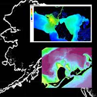
TCarta Marine won a Small Business Innovation Research (SBIR) Phase II grant from the National Oceanic and Atmospheric Administration (NOAA), focused on enhancing Satellite Derived Bathymetry technology for application in the coastal waters of Alaska.Satellite Derived Bathymetry (SDB) extracts water depth measurements from multispectral satellite imagery using advanced physics-based algorithms. Traditionally, this technology has yielded the most accurate results in clear, calm waters; however, TCarta has recently taken the lead in expanding SDB applications to more challenging marine environments
NSF Grant to Enhance Satellite-derived Bathymetry Technology
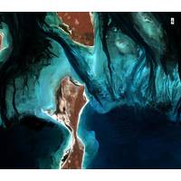
Marine has been awarded a research and development grant by the National Science Foundation (NSF) to enhance and automate multiple techniques for deriving seafloor depth measurements from optical satellite imagery. The ‘Project Trident’ research seeks to transform existing satellite derived bathymetry (SDB) techniques by leveraging machine learning and computer vision technology to enable accurate depth retrieval in variable water conditions.If successful, TCarta said, these enhanced bathymetric techniques will have positive impacts on operations related to oil and gas exploration and production
EdgeTech Plans On-water Demos for MTS TechSurge
on-board one of the two company-owned research vessels, the Ocean Researcher II. The vessel is docked in Ft. Lauderdale and is used to support the company’s local research and development office. Also during the conference, EdgeTech will give a talk on the latest bathymetry technology
Martzial Joins EdgeTech as Product Line Sales Engineer
;s bathymetric product line in the U.S., Canada and Latin America. Products and solutions in the bathymetric line include the pole-mounted shallow water 6205 system as well as deep towed systems and 2205 AUV, ROV and ASV based sonar systems which offer a combination of side scan, sub-bottom and bathymetry technology
Seatronics: Large Purchase of Sonar Equipment
Seatronics UAE Regional Manager, Jeff Holtom. “We are extremely pleased to have the opportunity to represent EdgeTech in the region, and as can been noted by this most recent investment, we have reinforced our commitment to this leading sonar brand, including the latest combined side can-bathymetry technology, the EdgeTech 4600.” “With this partnership, EdgeTech is showing its commitment to strengthen its geographical presence in the area, giving access to current and potential clients a wide range of side scan, sub-bottom and bathymetric products,” said EdgeTech&rsquo