NASA Sends Robots to Study Climate Change in the Arctic
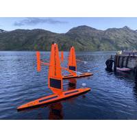
, like the centers of hurricanes and shifting packs of sea ice in the Arctic. They provide a resilient and affordable means to validate satellite data and develop and improve algorithms that model changing temperatures.The 2021 NASA Arctic Cruise is ongoing; the Saildrone USVs passed through the Bering Strait and are headed into the Chukchi Sea. In previous Saildrone missions, NASA researchers found close correlation between satellite remote sensing measurements of sea surface salinity and data collected by Saildrone.The path taken by the saildrones during the first 2.5 months of the mission, from
US Navy Submarines Surface in the Arctic Circle
under-ice transit of an ice floe in the Chukchi Sea. In 1958, the nuclear-powered USS NAUTILUS made the first crossing of the Arctic Ocean beneath the pack ice. The first Arctic surfacing was done by USS Skate (SSN 578) in March 1959. USS Sargo was the first submarine to conduct a winter Bering Strait transit in 1960. The units participating in the exercise are supported by a temporary ice camp on a moving ice floe approximately 150 miles off the coast of the northern slope of Alaska in international waters. The ice camp, administered by the Arctic Submarine Laboratory (ASL)
NOAA to Deploy Saildrones for Climate Study
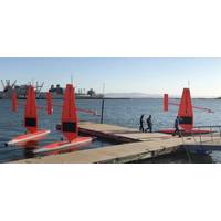
vehicles will soon travel thousands of miles across the ocean, reaching some areas never before surveyed with such specialized technology. In mid-July, scientists will send off the first unmanned, wind and solar-powered vehicles from Dutch Harbor, Alaska, with two sailing north through the Bering Strait into the Arctic Ocean and another transiting the Bering Sea. Traversing Alaska’s inhospitable waters, the remote-controlled vehicles will track melting ice, measure carbon dioxide in the ocean and count fish, seals and whales. For the first time, the vehicles will journey
NOAA to Boost Arctic Nautical Charting
NOAA plans increased 2015 Arctic nautical charting operations, coordinating with U.S. Coast Guard for safe shipping route from Unimark Pass through Bering Strait As commercial shipping traffic increases in the Arctic, NOAA informs it is taking steps to update nautical charts in the region. NOAA’s Office of Coast Survey will use data collected by two of its own ships, Rainier and Fairweather, as well as the U.S. Coast Guard cutter Healy and a private sector hydrographic contractor to cover nearly 12,000 nautical miles in the Arctic for use in updating its navigational charts.
US Unprepared for Arctic Oil Spill: New Report
The work of a committee, the National Research Council has released a new report – 'Responding to Oil Spills in the U.S. Arctic Marine Environment', which concludes that the the U.S. is far from ready to respond effectively to such an event. U.S. Arctic waters north of the Bering Strait and west of the Canadian border encompass a vast area that is usually ice covered for much of the year, but is increasingly experiencing longer periods and larger areas of open water due to climate change. Sparsely inhabited with a wide variety of ecosystems found nowhere else, this region is vulnerable to
When Will New Arctic Maritime Crossroad Open?
Ice Center. Vessels operating during shoulder seasons will require at least minimal ice-hardening and will require icebreaker escort. Predictions For the near-term, defined as present to 2020, current trends are expected to continue, with major waterways becoming increasingly open. By 2020, the Bering Strait (BS) is expected to see open water conditions approximately 160 days per year, with another 35 to 45 days of shoulder season. The Northern Sea Route (NSR) will experience around 30 days of open water conditions, also with up to 45 days of shoulder season conditions. Analysis suggests that the
Subsea Cable Project: Tokyo to London via NW Passage
United States to Europe and Asia. Arctic Fibre was established in 2009 to explore deploying a fibre optic telecommunications system through the Canadian Arctic. Arctic Fibre plans to construct a 15,167 km (9,424 mile) subsea fibre optic cable extending from Tokyo, Japan to London, England via the Bering Strait, Beaufort Sea and Canadian Arctic with a planned in-service date of November 2014. Arctic Fibre’s backbone network will reduce the cost of wholesale bandwidth by more than 85% in the Canadian communities of Cambridge Bay, Gjoa Haven, Taloyoak, Igloolik, Hall Beach, Cape Dorset and Iqaluit


