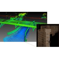
Teledyne to Debut New Marine Lidar Sensor for USVs
to Ocean Business 2023, being held at the National Oceanography Centre, Southampton, UK from April 18-20.Visitors to the Teledyne Geospatial booth U12 will be introduced to the CL-360 for marine applications, a lidar sensor that can be seamlessly integrated with high resolution multibeam systems and the CARIS Ping-To-Chart workflow, allowing for full above and below water image capture with survey grade accuracy in a single workflow. The sensor’s 360-degree scanner and up to 2 million points/second collection rate provides a premier solution for mapping coastal infrastructure. The CL-360 is the
Teledyne Geospatial Partners with Seabed 2030 to Study Submarine Impacts of Volcanic Eruption in Tonga
the volcano with RV Tangaroa. As part of phase two, SEA-KIT International’s Uncrewed Surface Vessel (USV) Maxlimer was used to conduct further mapping inside the caldera.For the duration of TESMaP, Seabed 2030 and Nippon Foundation-GEBCO Ocean Mapping Fellows utilized software provided by Teledyne CARIS (based in Fredericton, New Brunswick)—a Seabed 2030 partner with over 40 years of experience in developing hydrographic and marine geospatial software. The software was integral to the project as they facilitated the monitoring of data quality and coverage, with new data being used for comparative
UKHO Streamlines Bathymetric Data Cleansing Process
New tool uses AI and machine learning to identify sonar noise in bathymetric data sets and delivers substantial time efficiencies in cleansing and verification tasksThe UK Hydrographic Office (UKHO) announced its new ADMIRALTY GAM Service, developed in collaboration with Teledyne CARIS to improve efficiency during bathymetric data cleansing processes.The new ADMIRALTY GAM Service classifies and removes sonar noise from bathymetric survey data using machine learning based on a Generalised Additive Model (GAM). The service uses cloud computing capabilities to examine and cleanse new multi-beam survey
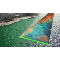
Lidar Helps to illuminate the Future of Oceans
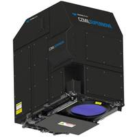
oceans for maintaining all life on Earth. Rapidly improving lidar technology and creative, new applications for it represent vectors to achieve that mission. The resulting solutions and discoveries will be as boundless as the seas below.Teledyne Optech launches CZMIL SuperNovaTeledyne Optech and Teledyne CARIS announced their next generation bathymetric lidar, the CZMIL SuperNova, which is touted by the companies as having the best depth performance and the highest green laser point density in its class. Introducing SmartSpacing technology for even and efficient point spacing, real-time processing capability

Terratec AS Takes Delivery of Next-gen CZMIL SuperNova Lidar Bathymetric Solution
The CZMIL SuperNova combines the deep bathymetric lidar experience of Teledyne Optech with comprehensive processing software from Teledyne CARIS to provide optimized geospatial solutionsTeledyne Optech delivered its next-gen bathymetric lidar CZMIL SuperNova to Terratec AS of Norway, the first private company to acquire the CZMIL SuperNova and the only company in the EU to engage in work around environmental change and coastal zone mapping using the CZMIL SuperNova.CZMIL SuperNova also introduces SmartSpacing technology to enhance efficient point spacing across the swath, onboard processing capability
CZMIL SuperNova Bathymetric Lidar Launched
The CZMIL SuperNova is powered by Teledyne CARIS processing software for creation of seamless topo/bathy data products.Teledyne Optech and Teledyne CARIS, both Teledyne Technologies [NYSE:TDY] companies and global leaders in advanced lidar sensors and marine mapping software, announce their next generation bathymetric lidar, the CZMIL SuperNova.The CZMIL SuperNova boasts the best depth performance and the highest green laser point density in its class. Introducing SmartSpacing technology for even and efficient point spacing, real-time processing capability for reduced post-processing time and configurab
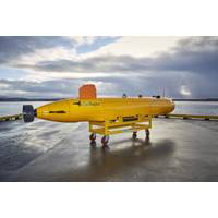
Argeo Buys Two SeaRaptor AUVs
will also be fitted with Teledyne RESON T50-S Multi-Beam dual frequency 200/400 kHz Echo Sounders, Teledyne Benthos Chirp III Sub Bottom Profilers, iXblue PHINS 6000 INSs coupled to Teledyne RDI Tasman DVLs, and CathX Hunter Camera Systems. All data collected will be processed onboard using Teledyne CARIS OnBoard postprocessing and mosaicking software to allow quick turnaround during missions. The AUVs are also fitted with a large variety of scientific sensors from RBR which will take Conductivity, Temperature, Pressure, Turbidity, pH, Dissolved Oxygen, Redox, CH4 and Magnetic measurements to provide
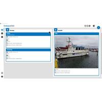
Teledyne CARIS Launches Onboard360
Teledyne CARIS released Onboard360 featuring CARIS Collect. The software is designed to deliver a seamless flow of data into the Ping-to-Chart workflow. When combined with the Onboard360 Process module, logged data is imported and processed automatically allowing near real-time and remote quality monitoring of in-progress surveys.“We are pleased to offer our customers the ability to collect with confidence using CARIS Onboard360," said Andy Hoggarth, VP Sales and Marketing. "Our Ping-to-Chart solution is now complete with the inclusion of the simplest acquisition software available
Teledyne CARIS receives Canada’s Ocean Supercluster Award
Teledyne CARIS announced significant funding from Canada’s Ocean Supercluster award to develop software for remote operations survey processing. .Teledyne CARIS’ project aims at three targeted deliverables:The enhancement of its desktop-based product line to leverage the cloud to deliver consistent access for global users in every possible circumstanceSupport for remote mapping operations to underpin advancements in ocean roboticsInfusing its passion for future ocean mappers with access to virtual training through the CARIS Cloud Platform. The company has partnered with Ocean Floor


