New Ocean Mapping Center Partnership
, Ph.D., NOAA Administrator. “Our continued partnership on the Center of Excellence will help build a workforce ready to tackle the mapping challenges of the future, and further our understanding of our changing ocean and coasts.”“The University of New Hampshire’s world-class Center for Coastal and Ocean Mapping and Joint Hydrographic Center has led the way for more than two decades in ocean mapping, helping ensure safe marine transportation and understanding coastal hazards. This leadership is affirmed by NOAA locating a new Center of Excellence for Operational Ocean and Great Lakes
Exail and UNH Open Maritime Autonomy Innovation Hub
, maintenance and training facilities, and providing expertise on maritime autonomy while also training future generations on the use of autonomous vessels.The new hub will be located within UNH’s Olson Advanced Manufacturing Center in Durham, to facilitate collaborative work with UNH’s Center for Coastal and Ocean Mapping (CCOM). University of New Hampshire is considered a leader in the field of ocean mapping research.“We’ve been working together with UNH for the past six years pioneering uncrewed technologies, and we are now capitalizing on our common achievements with the opening
North American Lobster Industry Confronts 'Ropeless' Traps After Whale Entanglements
swims through, color-coded rope for tracing, adding more traps per buoy line, and zone closures during whale migration.But whales are still getting entangled.“It doesn’t look like the solutions we’ve come up with are effective,” said Charles Mayo, senior scientist at the Center for Coastal Studies in Cape Cod, Massachusetts."Not effective to the point we need. We need a growing population. We don’t have that many whales left.”Washington and Ottawa are now promoting ropeless fishing as a possible long-term solution. Traditional lobster fishing uses traps that
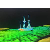
Discovery: Historic Shipwreck Found in Lake Huron
and four other Ironton crew: Mate Ed Bostwick, Sailor John Pope, and two unidentified sailors.Autonomous surface vessel (ASV) BEN pictured in the Rogers City Marina. Image Credit: Ocean Exploration Trust/NOAA Thunder Bay National Marine SanctuaryPilots from the University of New Hampshire’s Center for Coastal and Ocean Mapping operate ASV BEN from the Mobile Lab in Rogers City, Michigan. Image Credit: Ocean Exploration Trust/NOAA Thunder Bay National Marine SanctuaryQUOTABLE: Dr. Robert Ballard, President, Ocean Exploration Trust: “Our team is proud to partner with the Office of National
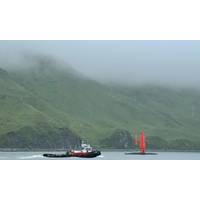
Uncrewed Saildrone to Explore Remote Alaskan Waters
All work conducted will contribute to the Seascape Alaska regional mapping campaign.Data will be collected by the innovative Saildrone Surveyor , the world’s largest and most advanced uncrewed surface vessel for ocean exploration. Along with Saildrone , the University of New Hampshire’s Center for Coastal and Ocean Mapping and NOAA Ocean Exploration staff will manage at-sea operations.The Surveyor is equipped with a suite of instruments to collect acoustic, oceanographic, and meteorological data to support a wide range of research applications. Piloted remotely from shore and powered primarily
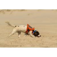
Dogs Trained to Detect Crude Oil on Gulf Coast Beaches
.Now, a few visionary researchers at Texas A&M University-Corpus Christi are interested in training canines to sniff out crude oil on Texas beaches. Poppy, an English Springer Spaniel, and Bin, a German Shorthaired Pointer, are part of the university’s new Oil Detection Canine study.At the Center for Coastal Studies (CCS), housed within the College of Science and Engineering at Texas A&M-Corpus Christi, a team is currently focused on training Bin to differentiate between naturally occurring weathered oil (tar balls) and fresher crude oils (example: oil spills) up to three feet below the sand
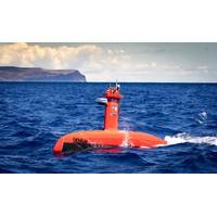
DriX USV Delivered to UNH CCOM
The University of New Hampshire’s Center for Coastal and Ocean Mapping (UNH CCOM), as a member of the Ocean Exploration Cooperative Institute (OECI), funded by NOAA Ocean Exploration, took delivery of an iXblue DriX Uncrewed Surface Vehicle (USV) and its Universal Deployment System. The autonomous solution will help expand the footprint and efficiency of the OECI’s ocean exploration operations. Delivered in July to UNH CCOM, DriX and its novel Universal Deployment System have completed sea acceptance trials and extensive personnel training during the summer of 2021 as well as integratio
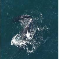
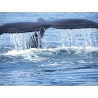
Report: Population of North Atlantic right whales Hits 20-year Low
. History has shown right whales are a resilient species that can recover if humans provide an ocean habitat suitable for these whales to thrive.The North Atlantic Right Whale Consortium, which was co-founded in 1986 by the New England Aquarium and partners from the University of Rhode Island, the Center for Coastal Studies, Marineland of Florida, and Woods Hole Oceanographic Institution, formed as a means for right whale researchers to collaborate and share data in order to understand and protect the species. The Consortium is holding its annual meeting this week, and following the meeting it will
NOAA HSRP Public Meet Webinar set for September 1-2, 2021
navigation services, observations and positioning including topics affecting the NOS’ Office of Coast Survey, Center for Operational Oceanographic Products and Services, National Geodetic Survey, and the University of New Hampshire’s and NOAA’s Joint Hydrographic Center (JHC) and Center for Coastal Ocean Mapping. The HSRP advises the NOAA Administrator on matters that affect marine transportation, safe navigation, commercial shipping, ocean and coastal stewardship including sea level rise, resilience, flooding and inundation, coastal and marine spatial planning, geospatial and geodetic