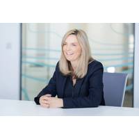
UKHO Appoints Blake Interim Chief Executive
The UK Hydrographic Office (UKHO) appointed Vanessa Blake to the position of interim Chief Executive and Accounting Officer.Blake is the current Chief Customer Officer at the UKHO and will take up the role of Chief Executive on an interim basis, while a permanent replacement is sought. She will succeed Peter Sparkes, who leaves in May 2024, to become the Chief Executive of the RNLI, after nearly four years in the role.Blake joined the UKHO in July 2023 as Chief Customer Officer, during which time she developed and implemented the customer strategy that sits at the heart of the UKHO’s new corporate
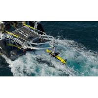
Kraken Robotics Reels In $2.4M Sonar and Subsea Power Contracts
Canadian company Kraken Robotics has secured contracts totaling $2.4 million for subsea batteries and synthetic aperture sonar systems (SAS).The SAS sensor contracts are for a Research Institute and a Hydrographic Office of an unnamed Navy.No details can be provided on the subsea power customer due to confidentiality, Kraken Robotics informed.Deliveries of the systems will take place in 2024.
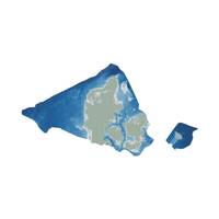
Danish Geodata Agency, EOMAP to Chart the Shallow Waters of Denmark.
partnership, and to integrate the SDB data into the Danish Depth Model (DDM).Using cutting-edge satellite technology, the cooperation will provide better mapping of shallow water areas lacking bathymetric coverage. This will also help improve the coverage of the DDM developed by the Danish Hydrographic Office, a part of the Danish Geodata Agency.“Finding new ways to map shallow waters, where we only have very old data, and increasing the utilization of depth data for marine stakeholders and society is central in the goals of the Danish Hydrographic Office. Satellite technology shows great
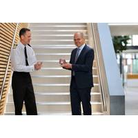
Marc van der Donck Receives 2022 Alexander Dalrymple Award
The UK Hydrographic Office (UKHO) presented Marc van der Donck, Retired Captain in the Netherlands Navy and Chairman of the International Center for Electronic Navigational Charts (IC-ENC), the 2022 Alexander Dalrymple Award for services to international hydrography.Captain Marc received the award on World Hydrography Day in a ceremony led by UK National Hydrographer Rear Admiral Rhett Hatcher at the UKHO’s office in Taunton, England. The 2022 presentation took place this year due to delays in awarding previous winners caused by Covid-19.The 2022 award recognizes Capt Marc’s positive
UKHO Provides Bathymetric Surveys for Seabed 2030
Marking the first time the UKHO supplies data directly to GEBCO, this initiative aims to advance the understanding of ocean bathymetry and support the Decade of Ocean Science for Sustainable DevelopmentThe UK Hydrographic Office (UKHO) has started supplying bathymetric survey data for non-UK waters to the General Bathymetric Chart of the Oceans (GEBCO), after signing the memorandum of understanding (MOU) with The Nippon Founda-tion-GEBCO Seabed 2030 Project (Seabed 2030) earlier this year.The MOU was signed with the goal of advancing the industry’s understanding of ocean bathymetry and supporting
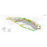
UKHO supports Montserrat with Seabed Mapping Data Survey
The UK Hydrographic Office (UKHO) has conducted a seabed mapping data survey in Montserrat to improve the safety of navigation around the island and to help with understanding, managing, and protecting its marine life.For this project, funded by the UK’s Conflict, Security and Stability Fund (CSSF), the UKHO worked alongside the Montserrat Hydrographic Survey Team to collect data from the waters around the island. The UKHO data survey team returned to the UK in early September after spending four weeks gathering information from Montserrat’s nearby waters. The team will now validate
Inside the new UK Center for Seabed Mapping
David Parker, the Head of Hydrographic Programs at the UK Hydrographic Office (UKHO) discusses the rationale behind the new UK Center for Seabed Mapping, with insight on seabed mapping and its connection to the Blue Economy.There are few more prestigious names in the world of hydrography than the UKHO, the world’s largest center for hydrography. UKHO support a staff of 900 in Taunton, UK, with a small contingent in satellite offices in Singapore and Washington, DC. Its ADMIRALTY Maritime Data Solution product portfolio includes a series of around 18,000 electronic navigational charts which

UKHO Appoints Marion Leslie as Non-Executive Chair
The UK Hydrographic Office (UKHO) confirmed the appointment of Marion Leslie as Non-Executive Chair. Leslie will chair the UKHO Board in this independent position after a year as interim Non-Executive Chair and six years as a Non-Executive Director at the UKHO.The Board supports, challenges and validates the UKHO business strategy and oversees the organization's performance. Leslie leads the Board as Chair, acting in the interests of the Ministry of Defense and key stakeholders, and supports and provides guidance to Peter Sparkes, UKHO’s Chief Executive.UKHO exists to support safe, secure
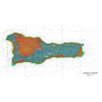
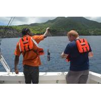
UKHO Seabed Mapping data to help drive maritime trade and growth in Cayman Islands
Seabed mapping survey sheds light on the shape of the sea floor and habitat areas in surrounding waters, supports the islands’ sustainable blue economy and enables safe navigation.The UK Hydrographic Office (UKHO) completed a seabed mapping survey for the Cayman Islands, uncovering information about the depth and nature of the seabed and its ecosystems. Geospatial data from the six-month study, launched in November 2021, was undertaken through the UK Government’s Conflict, Security and Stability Fund (CSSF), under the Overseas Territories Seabed Mapping Programme. Data was gathered