Marc van der Donck Receives 2022 Alexander Dalrymple Award
of the MACHC, which he chaired for two years.In 2016, 2018 and 2021, Capt Marc represented the Netherlands Navy at the North Sea Hydrographic Commission. He has attended Inter-Regional Coordination Committee meetings on behalf of the RHC, helping shape policy decisions for one of the International Hydrographic Organization’s key vehicles for progress, and contributed to strategic developments at the North Sea Hydrographic Commission.Elsewhere, Capt Marc has led the Worldwide ENC Database Working Group through its transition from S57 Electronic Navigational Charts to WEND100 – the framework
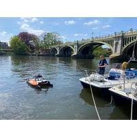
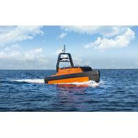
Port of London Launches Fully-electric Survey Vessel
;s Richmond Lock and Weir, by UCL’s latest cohort of international MSC students supported by the PLA Hydrographic Service Team.Since 1999, the PLA’s Hydrography team have worked in partnership with UCL Civil, Environmental and Geomatics Engineering (CEGE) to deliver the International Hydrographic Organization (IHO) accredited Category A MSc in Geospatial Science, Hydrographic Surveying. The only CAT A accredited course in the UK, supporting the education of future hydrographic surveyors from around the world.UCL CEGE’s lecturer in marine geospatial science, Dr. Cassandra Nanlal
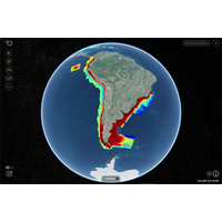
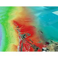
Saildrone, Seabed 2030 in Ocean Mapping Partnership
a collaborative project between The Nippon Foundation and GEBCO (The General Bathymetric Chart of the Oceans) to inspire the complete mapping of the world's oceans by 2030 and to compile all bathymetric data into the freely available GEBCO Ocean Map. GEBCO is a joint program of the International Hydrographic Organization (IHO) and the Intergovernmental Oceanographic Commission (IOC) and is the only organization with a mandate to map the entire ocean floor.“We can only realize our goal of a complete map of the ocean floor if we mobilize the international community and work together. We are therefore
Seabed 2030 Enters Partnership with Terradepth
ocean floor.Seabed 2030 is a collaborative project between The Nippon Foundation in Japan and the General Bathymetric Chart of the Oceans (GEBCO) with the mission of inspiring 100% mapping of the ocean floor and making it freely available to all by 2030. GEBCO is a joint program of the International Hydrographic Organization (IHO) and the Intergovernmental Oceanographic Commission of UNESCO (IOC-UNESCO). Seabed 2030 comprises five Data Centers – four Regional Centers and one Global Center – which are responsible for coordinating and assembling mapping data.In addition to producing and delivering
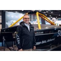
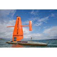
Shep Smith Appointed XOCEAN CTO
Commanding Officer and Chief Scientist of the NOAA Ship Thomas Jefferson. In his final role with NOAA, he served as Director of the Office of Coast Survey, where he oversaw the US national programs in hydrography and nautical cartography. Smith also represented the United States at the International Hydrographic Organization and regional hydrographic commissions. Smith will be responsible for propelling XOCEAN to its next phase of growth: developing XOCEAN’s technology roadmap, advancing the boundaries of uncrewed surface vessel (USV) tech, and driving the technical vision for the business
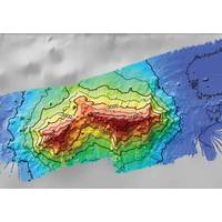
Seamount Named for Iconic Oceanographer Walter Munk
Researchers at Scripps Institution of Oceanography at UC San Diego announced this week the naming of a newly discovered seafloor feature for the late Scripps Oceanography geophysicist Walter Munk.The International Hydrographic Organization approved the naming of the Walter Munk Guyot (pronounced GEE-oh), a type of seamount distinguished by having a flat peak. The guyot is located 1,600 kilometers (1,000 miles) southwest of Honolulu and rises 3,803 meters (12,500 feet) above the seafloor. Its peak is 1,397 meters (4,583 feet) below sea level.“This is a love letter to Walter from all of Scripps
The Nippon Foundation-GEBCO Seabed 2030 Project Partner with TCarta
and hydrospatial data services.Seabed 2030 is a collaborative project between The Nippon Foundation and GEBCO to inspire the complete mapping of the world's ocean by 2030, and to compile all bathymetric data into the freely available GEBCO Ocean Map. GEBCO is a joint project of the International Hydrographic Organization (IHO) and the Intergovernmental Oceanographic Commission (IOC) and is the only organisation with a mandate to map the entire ocean floor. Seabed 2030 is formally endorsed as a Decade Action of the UN Decade of Ocean Science for Sustainable Development.TCarta has been a global innovator

Global Hydrographic Innovation and Technology Laboratory Established in Singapore
Singapore and the International Hydrographic Organization (IHO) have launched the Joint IHO-Singapore Innovation and Technology Laboratory.The Laboratory seeks to optimize the resources of IHO Member States to harness and develop emerging technologies in the hydrographic domain that support safe maritime navigation and the protection of the marine environment. In accelerating innovation in the field of hydrography, the Laboratory aims to:Conduct research and testing of projects proposed by IHO Member States, IHO organs and other stakeholders; Grow knowledge and foster collaboration on global
Kongsberg Maritime Signs on to help fast-track Seabed 2030 Project
map of the ocean floor. Seabed 2030 is a collaborative project between The Nippon Foundation and GEBCO to inspire the complete mapping of the world's ocean by 2030, and to compile all bathymetric data into the freely available GEBCO Ocean Map. GEBCO is a joint project of the International Hydrographic Organization (IHO) and the Intergovernmental Oceanographic Commission (IOC), and is the only organisation with a mandate to map the entire ocean floor.All data collected and shared with the Seabed 2030 Project is included in the GEBCO global grid, which is free and publicly available.Photo courtesy