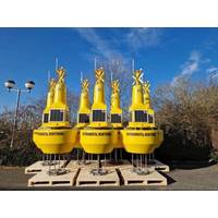
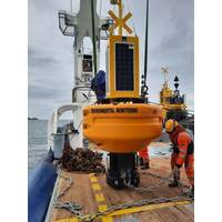
OSIL Dredge Monitoring Buoy Network for Van Oord
buoy networks will support dredging operations by providing continuous real-time information about the dredge plume and surrounding environmental conditions.The buoys are equipped with water quality sondes provided from Van Oord’s existing equipment pool, and relay collected data via GSM with an Iridium satellite Short Burst Data (SBD) back up. The systems are self-contained, being furnished with sufficient solar power (which can be combined with alternative power sources) and back-up batteries to sustain the power demands of the systems. Data can be relayed from the buoys immediately and
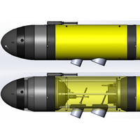
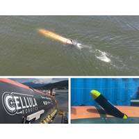
Teledyne Integrating the Kongsberg EK80 WBT Mini Into Its Slocum Gliders
turbulence.The Slocum Glider is the world’s most prolific autonomous gliding platform, a subsea vehicle that uses changes in buoyancy to efficiently move through the water, allowing it to persistently monitor the ocean water column for months at a time, and transmit gathered data shoreside via an iridium satellite connection. Slocum Gliders are used across a wide-ranging set of missions, including deployments serving Oceanographers, Fisheries, Energy Producers, and Military customers.Rendering of Teledyne Slocum G3s Glider with Kongsberg WBT Mini EK80 Integration (Image: Teledyne Marine)The
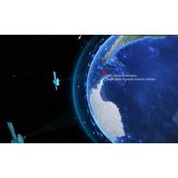
Canada and Spain Scientists Establish Antarctic Ocean Observatory
; - Jordi Sorribas Cervantes, director of the Unit of Marine Technology of the CSIC.The proposed site of the cabled seafloor observatory is in a small embayment called Johnsons Dock at a depth of 23 metres. It is modelled on one of ONC’s Arctic observatories at Gascoyne Inlet, and will use the Iridium satellite network to transmit the data every 30 minutes to ONC for processing, archival and distribution.The observatory will consist of a CTD scientific instrument that measures conductivity, temperature and depth. Additional sensors will track dissolved oxygen concentrations as well as optical
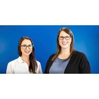
MetOcean Promotes Squires and MacDonald to Director Roles
MetOcean Telematics, a global Iridium satellite Value-Added Reseller headquartered in Canada, announced the promotion of Laura Squires to Director of Business Intelligence and Cathy MacDonald to Director of Finance.In this new capacity, Squires will be responsible for overseeing the management, development, and implementation of Business Intelligence initiatives. Her primary role is to promote data-driven decision-making by providing accurate and actionable insights to key stakeholders.Since joining MetOcean in February 2013, Squires has advanced from a Sales Operations Manager and Business Analyst to
OSIL Buoy for Dublin City University Project
1.9m OSIL Fulmar buoy is recording and transmitting a variety of environmental parameters including salinity, temperature, pH, partial pressure of CO2, turbidity, dissolved oxygen and chlorophyll, in addition to a full suite of meteorological measurements.Data from the buoy is relayed via GSM, with an Iridium satellite Short Burst Data back-up. The data is immediately available to the public via a web portal, and data from all sources will soon be publicly available on the easy to use PREDICT Data Portal. The environmental data is catalogued, mapped & displayed in an interactive web environment,
Hydrogen Fuel Cell Powered AUV Demonstrated
.The missions, executed in Vancouver's Indian Arm inlet on July 15, demonstrated the remarkable autonomous launch of a micro-AUV from Solus-LR while submerged and underway. Following the launch, the micro-AUV surfaced and transmitted a status message to Solus-LR's command and control center via Iridium satellite. The operation was the first of its kind and demonstrated near real-time, over-the-horizon communications from a submerged AUV.The demonstration was observed by representatives from Trusted Autonomous Systems (TAS), the Royal Australian Navy, Royal Canadian Navy, Defense Research Development
Subsea Robotics: Boaty McBoatface Heads to Antarctica
in this region.The team from NOC is sending the Boaty under the ice shelf into poorly mapped and potentially very rough submarine topography and will control it from the Nathaniel B Palmer research ship using the NOC-developed Command and Control system (C2), which can re-task Boaty over Wi-Fi, via iridium satellite or using an acoustic modem once it is submerged. The ALR will measure temperature, salinity, current velocity, turbulence, turbidity and dissolved oxygen content of the water, as well as surveying several transects from the edge and towards the grounding line of the ice shelf. Depending
Academia’s Climate Change Challenge is Far from Academic
and the chlorophyll sensors to detect how deep light (needed for photosynthesis) is penetrating,” Johnson explained. “Each float profiles from about 2 km depth to the surface every 10 days, making measurements on the way up. At the surface, each float sends the data home through the Iridium satellite network.” Phytoplankton consume carbon dioxide and release oxygen at a specific ratio, and by measuring oxygen release over time, scientists can better understand the role played by marine life in the carbon cycle. By combining the work of hundreds of floats that reach the surface
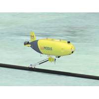
Modus Orders Unique Subsea Pipeline Inspection AUV from Kawasaki
. 1.4 mHeightApprox. 1.1 mWeightApprox. 2,500 kg (in air)Max. depth3,000 mMax. speed4 knotsPropulsion equipmentMain propulsion propeller ×1, side thrusters ×2,vertical thrusters ×2Navigation equipmentInertial navigation system, sonarSafety equipmentBallast release equipment, iridium beaco


