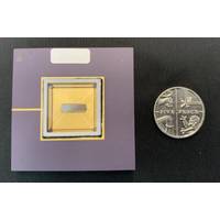
Partners Developing Underwater Single Photon Imaging System
viable subsea mapping system and consists of: Sonardyne International Ltd — with over 50 years expertise in the provision of underwater positioning, sensing, and imaging systems; leading the project, system integration and testing.Fraunhofer UK Research Ltd — are developing the laser system and environmental testing.RedWave Labs Ltd - are designing and building the rugged and compact control electronics for the 100 pico-second pulsed laser source.Photon Force Ltd - are developing a next-generation 1D SPAD array sensor and accompanying FPGA for onboard processing targeted at imaging
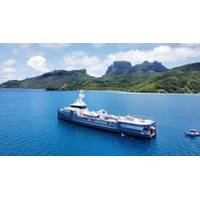
Expedition Yacht Deploys Falcon as a 'Rescue Robot'
is a proven commercial choice, so fits their criteria, “and it makes sense because we already have a Falcon aboard another vessel in our fleet.”For Dapple, the Falcon is equipped with an extensive range of technology including HDTV cameras, a multifrequency scanning sonar, multibeam sonar, laser system and an eventing suite. It also comes with both a three jaw and a five-function manipulator, each with rope cutters, along with hydraulic cable cutter and rotary cleaning brush.Although the Falcon’s key role is recovery of Dapple’s submersible, for general diving safety the Falcon can
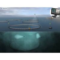
Aquaculture: Norwegian Researchers Work on 'Revolutionizing' Fish Farming
; the net as it moved along the cir-cumference of the cage – and that indeed turned out to be the case. The DVL is part of a package of navigational aids, which Walter Caharija describes as a “sensor fusion”. Ultra-short baseline acoustic positioning (USBL), compass readings, a laser system and the on-board camera all contribute location data. But, in terms of maintaining distance from the cage net, it is the DVL that does the work. Caharija says the Nortek DVL has done the job well. The team used laser measurements to verify those from the DVL and they
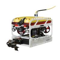
Falcon ROV Chosen for Project off West Africa
Integrated Services, said, “We ordered a survey customized Falcon ROV to support our subsea inspection / installation projects in West African waters.”The customized survey suite on Geocadinal’s Falcon includes a Digital Edge HDD dual channel recording and eventing system, a dual laser system for video survey and measurement, and a Tritech sonar.The vehicle also comes with five function hydraulic and single function manipulators, a rotary wire cleaning brush kit, cathodic potential probe kit and Cygnus ultrasonic thickness gauge. Also included is a Falcon running lock system.The Falcon
Kraken Wins Canadian Government Contract
underwater laser products require a combination of a high-grade navigation payload for motion correction and require a larger stable ROV. Other market solutions for subsea 3D asset reconstruction are based on photogrammetry and inherently have less precision and range than Kraken’s SeaVision 3D laser system. We are confident that SeaVision offers a superior price and performance value proposition.&rdquo
Flying new Routes Subsea
by inaccuracy caused by positioning tolerances. “Because of these systems the AUV can, in effect, see the pipeline, it means that USBL aiding isn’t always required to perform a pipeline inspection, enabling autonomous operations away from support vessels,” says Ward. “The CathX Laser system provides a very high-resolution point cloud of the pipeline and adjacent seabed. The Laser and MBES point clouds were combined in post processing and used to assess position and possible freespans. The very high resolution obtained from the laser system makes it suitable for spool deflection and
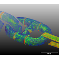
3D at Depth Completes 300 Offshore LiDAR Metrologies
clear advantages of subsea LIDAR laser metrologies over traditional laser scanning and conventional methods. To date, the company has conducted metrology projects in the U.S., Europe, Mediterranean and Asia and has operated in up to 4,000 meters in depth. Each 3D at Depth subsea LiDAR (SL) laser system is powered by in-house patented algorithm software and customized optical design. Every metrology application leverages the unique features of subsea LiDAR technology which includes touchless, total beam control scans with ranges up to 45 meters during the data collection process. From
Seatronics Renews Partnership with 2G Robotics
the detail needed to comprehensively assess subsea assets, develop effective design and repair solutions, and make informed decisions in order to ensure continued safe offshore operation. The systems can be diver deployed or integrated with ROVs or AUVs for dynamic scanning. 2G Robotics’ ULS-500 laser system has been specifically developed for dynamic scanning with development focused on subsea vehicle integrations, high sample rates, timing synchronization, and continuous data acquisition for faster, more efficient inspections. With underwater laser scanning becoming a leading inspection
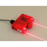
New Underwater Laser Scaler: SB10 Sea Beam
A new laser system from Laser Tools Co., Inc. called the SB10 Sea Beam assists in size measurements at a distance that’s certified waterproof to over 1,000 feet. This system is used to scale unusual objects, fish, reefs, artificial structures and mechanical fixtures at depths where divers can’t explore or the cost is too great. The SB10 Sea Beam Laser Scaler shoots two laser beams 75 millimeters apart that the remotely operated vehicle (ROV) views by camera. The laser dots or lines are measured using video capture techniques and the range and size of the target is analyzed.


