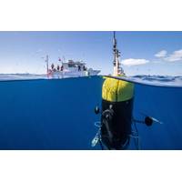
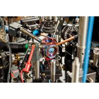
Argeo Builds the Tools to Bridge the Data Gap
side [which can be leveraged across many markets]. It’s a whole family of electromagnetic systems that is being developed and patented. So that’s the one thing. The other thing is a deep understanding of AUVs. I think we have 10 sensors now, in the high-specifications AUVs, we have cameras, lasers, SaaS, navigation data, and so forth. So many sensors. Over the course of maybe two days, we amass up to five terabytes of data. Huge amounts of data.Historically, a lot of that data becomes dead data on the client side. How do you make use of all of that information? That’s why we also started
Subsea: Argeo Builds the Tools to Bridge the Data Gap
can be leveraged across many markets]. It's a whole family electromagnetic systems that is being developed, commercialized and patented. So that's the one thing.The other thing is a deep understanding of AUVs. I think we have 10 sensors now, in the high-specifications AUVs, we have cameras, lasers, SaaS, navigation data, and so forth. So many sensors. Over the course of maybe two days, we amass up to five terabytes of data. Huge amounts of data.Historically, a lot of that data becomes dead data on the client side. How do you make use of all of that information? That's why we also started
The Ocean Could Store Vast Amounts of Captured Carbon – But We Need Deep Ocean Sensors to Track the Effects
launch a new era of ocean observing and discovery.Does the technology needed for this level of monitoring exist?We’re already doing much of this engineering and technology development. What we haven’t done yet is stitch it all together.For example, we have a team that works with blue light lasers for communicating in the ocean. Underwater, you can’t use electromagnetic radiation as cellphones do, because seawater is conductive. Instead, you have to use sound or light to communicate underwater.We also have an acoustics communications group that works on swarming technologies and communication
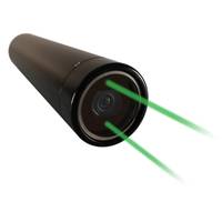
New Battery Option for Mako 4K Subsea Video Cam
video at 30 fps. The new internal battery option for Mako allows for standalone operation, a perfect complement to Mako's existing capability of using preset recording schedules and onboard recording.The original Mako is powered via a MCBH8M Subconn connector. Both options allow for optional scaling lasers and can be rated to 1,000 or 6,000m.All Mako cameras support external, directly connected lighting with remote lighting control. This new battery option for Mako pairs well with ViperFish, the low-power, dual-channel torch light, or LanternFish, Arctic Rays' battery-powered torch light
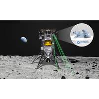
Advanced Navigation Wants to Be First Australian Firm to Reach the Moon
extreme precision without using relatively fixed references, such as stars, or requiring base station control telemetry. This is critical for long-endurance space missions involving complex orbits and trajectories, the company said."The light detection altimetry and velocimetry (LiDAV) system uses lasers to measure a significant number of parameters detailing a vehicle's environment. Most importantly it can indicate the vehicle’s velocity and position relative to the lunar surface in three dimensions with extreme accuracy and precision. When visual references are unavailable and cameras
Meet NOUS: An Underwater ‘Artificial Mind’
technology and have a wide-angle lens. Each camera is connected to a local computer, which uses appropriate software to monitor its operating parameters. It is also possible to install additional instruments such as measuring sensors for the abiotic environment, underwater lights for night observations, lasers, infra-red cameras, etc.The computer communicates via an Ethernet network with the other devices in the system, for transferring images and measurements (ie. electrical quality, speed and network status, etc.). It has a Linux operating system which allow to add applications, change settings remotely
Shed the Satellite: Quantum Sensors hold Promise for Future GPS-Free Navigation
systems on commercial and military vehicles alike, Schwindt said.So instead of relying on satellites, Schwindt said future vehicles might keep track of their own position. They could do that with on-board devices as accurate as atomic clocks, but that measure acceleration and rotation by shining lasers into small clouds of rubidium gas like the one Sandia has contained.Sandia National Laboratories scientist Peter Schwindt, left, and postdoctoral scientist Bethany Little examine the vacuum package held in a yellow, 3D-printed mount. (Photo by Bret Latter) Click on the thumbnail for a high-resolution
Lidar Helps to illuminate the Future of Oceans
routes, and maintenance inspection. In the marine world, lidar has gained a reputation for increasing our exploratory efforts and, more recently, for examining the coastal ecosystems, communities, and structures that grow increasingly sen-sitive to climate change and intensifying weather patterns.Lasers: A Shore way to Protect the CoastVelodyne Lidar, a lidar solutions company based in California, has recently partnered with Sea-bed B.V., a technical solutions group from the Netherlands, to help complete a lidar mobile mapping system. With the goal of protecting sensitive shorelines through sustainable
ROV @ Work: Falcon deployed in France for Bridge, Dam Inspection
;ment Chaudouet of IDCBTP. “It's also a stable system, which is very important to us as we need perfect control of the ROV during a dam inspection.”For a clear and accurate analysis of the condition of the structures, IDCBTP’s Falcon is fitted with a range of systems including lasers, multibeam sonar, profiler sonar and navigation and positioning systems. Precision data collected in this way can identify repairs needed, help maintenance planning and spot trends in structure condition.Two structures under inspection are the bridge supports for the Pont de la Pyle at Lake Vouglans