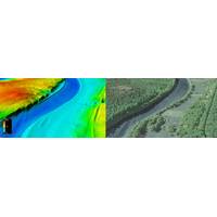
USGS : New Topobathymetric Dataset for Potomac River
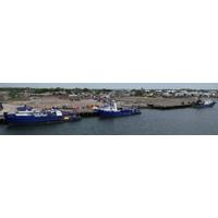
Teledyne Geospatial said the U.S. Geological Survey (USGS) and Dewberry, a privately held professional services firm, published a new topobathymetric lidar dataset for the Potomac River. The Potomac River flows from the Potomac Highlands in West Virginia to the Chesapeake Bay in Maryland. The lidar survey was conducted for USGS’s 3D Elevation Program (3DEP), with stakeholders including the USGS Earth Resources Observation and Science Center (EROS), National Geospatial Program (NGP), and Eastern Ecological Science Center (EESC) programs, as well as the Interstate Commission on the Potomac
US Awards $6.7 Million for Sea Level Rise and Coastal Resilience Research
University of California, Irvine and University of Miami received nearly $500,000 to evaluate how nature-based solutions can empower more equitable flood risk management in Los Angeles County, California.(IRA-funded) George Mason University, The Nature Conservancy, Resources for the Future and Maryland Department of Natural Resources received nearly $500,000 to evaluate flood mitigation designs under future climate scenarios to inform restoration efforts in the Chesapeake Bay region.University of Texas at Arlington and University of Arkansas received nearly $500,000 to evaluate how different shoreline
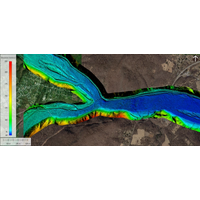
New USGS National Map Data Reveals the Potomac River’s Submerged Topography
biological assessments, flood mapping, and many other applications.The lidar point clouds and topobathymetric digital elevation models for the Potomac River Basin can be visualized or downloaded through the 3DEP LidarExplorer here.Map of the Potomac River topobathymetric lidar survey area in Virginia, Maryland, and West Virginia. (Image: USGS
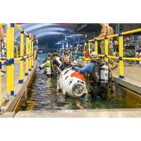
Carderock Hosts International Submarine Race
Naval Surface Warfare Center, Carderock Division welcomed the return of the International Submarine Race (ISR) to its David Taylor Model Basin in West Bethesda, Maryland, June 26-30, for the first time since before the COVID-19 Pandemic.Teams from across the United States, Poland, the United Kingdom and Canada arrived at Carderock with their eyes set on one mission: be the fastest human-powered submarine in the competition.The biennial science, technology, engineering and mathematics (STEM) event allows students to display their talents and problem-solving capabilities in submarine and hull design
TDI-Brooks Awarded Geotechnical Coring Project Off US East Coast
, offshore wind energy facility in Commercial Lease OCS-A 0508, with up to 69 total wind turbine generators, an offshore substation, inter-array cables, an onshore substation, and up to two transmission cables making landfall in Virginia Beach, Virginia, and connecting to the Pennsylvania-New Jersey-Maryland (PJM) Interconnection energy grid. This project is intended to substantially contribute to the region’s electrical reliability and help Virginia achieve its renewable energy goals as stated in the Virginia Clean Economy Act
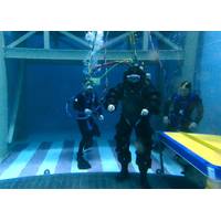
US Navy Tests Flexible One-Atmosphere Diving Suit
and maneuverability.Sponsored by the Office of Naval Research (ONR) — in partnership with Naval Sea Systems Command (NAVSEA), Naval Undersea Warfare Center (NUWC) and Naval Surface Warfare Center (NSWC) Panama City — DSEND recently underwent demonstrations at NSWC Carderock Division in Maryland and at the Navy Experimental Diving Unit in Florida.Although constructed from hard, durable material, DSEND is lightweight and enables users to swim and walk on the bottom easily. This improves on atmospheric diving suits traditionally used by the Navy in the past, which were more rigid and powered
Army Corps, Maryland DOT to Commence $4 Billion Chesapeake Bay Restoration Project
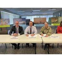
The U.S. Army Corps of Engineers (USACE), Baltimore District, and the Maryland Department of Transportation (MDOT) signed a Project Partnership Agreement (PPA) for the $4 billion Mid-Chesapeake Bay ecosystem restoration project at MDOT Headquarters, August 23, 2022.The PPA – signed by Col. Estee Pinchasin, Baltimore District commander, and MDOT Secretary James F. Ports, Jr. – outlines the roles, responsibilities, and financial obligations for both partners for the restoration of both James and Barren islands in Dorchester County, beneficially re-using material dredged from the Port of

Steve Thur Named Director of NOAA Research
be joining these dedicated professionals in service to the American public through science.”Thur received a Ph.D. in marine policy from the University of Delaware’s Graduate College of Marine Studies. He holds bachelor’s degrees in biology and economics from St. Mary’s College of Maryland.With a workforce of 2,280 employees and affiliates, and 10 laboratories across the country, NOAA Research provides the science and research foundation to better understand our planet. Working in partnership with other NOAA offices and a variety of partners — including cooperative institutes
Greensea Advancing Autonomous Hull Cleaning for the US Navy
cleaning robot will be capable of determining and continually updating its position on the ship’s hull with extreme accuracy, allowing Greensea’s autonomy capabilities to free the operator from driving the robot.To achieve the goals of Phase II, Greensea has partnered with the University of Maryland Centre for Environmental Science’s Maritime Environmental Resource Center (MERC) and Armach Robotics. MERC brings significant expertise in biofouling control methods and will provide critical support in independent, scientific assessments of the robots’ navigation, autonomy and cleaning


