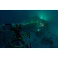
Subsea Wreck Brought to Life by Lasers
of materials conservation of watercraft and aircraft with the Conservation Research Laboratory and Center for Maritime Archaeology and Conservation (CMAC) at Texas A&M University, the Devastator Project team consisted of Brett Seymour, a top-flight underwater photographer on loan from the National Park Service's Submerged Resources Center; Evan Kovacs, an innovative engineer and experienced technical diver who runs Marine Imaging Technologies; Matt Christie, Senior Subsea LiDAR Specialist with 3D at Depth; Brian Kirk, an expert local guide and original co-discoverer (with historian/explorer
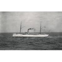
US Coast Guard Shipwreck Found – 100 Years Later
courthouse for far-flung Alaskan towns. Last October, a joint NOAA and Coast Guard training mission confirmed the location of McCulloch’s remains. Working off the Channel Islands National Marine Sanctuary’s research vessel Shearwater, the multi-agency science team from NOAA, National Park Service, and Coast Guard Dive Lockers Alameda and San Diego, deployed a VideoRay remotely operated vehicle to survey and characterize the shipwreck. Coast Guard 11th District cutters Halibut and Blacktip provided vessel support. Cameras mounted on the remotely operated underwater vehicle
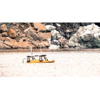
Case Study: Mapping a Glacial Landslide
. The goals of that trip were to map the fjord floor with multibeam sonar and other seismic geophysical techniques that would allow them to see below the surface to determine the thickness of the landslide debris. Along with Shugar were a large group of scientists from Columbia University, the National Park Service, University of British Columbia and elsewhere. The team’s plan was to map the submarine deposits with the UW-Tacoma’s Z-Boat 1800 RP named ‘Jökull’ (Icelandic for glacier) with help from Jeremy Venditti, a professor from Simon Fraser University in Canada
Gulf Coast Coastal Restoration Work Awarded
off the coast of Mississippi which was breached during a hurricane. It is a critical piece of infrastructure that helps mitigate the damage caused by storms, thereby helping to protect communities. We look forward to working with U.S. Army Corps of Engineers, Mobile District and the National Park Service as we execute this important project.&rdquo
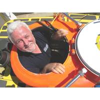
View from the Top: Dr. James Delgado, NOAA Director of Maritime Heritage
called him to his future path. He rescued more than 100 burials from destruction as well as many artifacts. The skeletal remains were reburied by the Ohlone descendants. Later, beginning in his junior high school years, he began working with local archaeologists, and at age 20, joined the National Park Service. There, he learned to scuba dive while working as an historian and archaeologist for the National Park Service in San Francisco. Not surprisingly, his career has taken him all over the globe and to several hundred fathoms under the sea. He has been part of some of the world&rsquo
BOEM Proposes New Regulation for OCS
restored more than 269 miles of coastline. BOEM has established strong and effective partnerships, including those with state geological surveys and environmental agencies, the U.S. Army Corps of Engineers, U.S. Geological Survey, National Marine Fisheries Service, U.S. Fish and Wildlife Service, National Park Service, National Aeronautics and Space Administration, and the Department of Defense. The Secretary of the Interior was authorized to negotiate non-competitive agreements for the use of these marine minerals for coastal restoration by an Outer Continental Shelf Lands Act amendment in 1994. Since
US, Cuba Open Doors to Marine Science Cooperation
Atlantic, Gulf of Mexico and Caribbean region. “They’re a conveyor belt, moving important marine life between our countries. Working together will help us better preserve these natural resources to benefit people in both our countries.” Late last year, NOAA, the U.S. National Park Service and Cuba’s National Center for Protected Areas agreed to share research to help the countries work together on some of the Caribbean’s most ecologically significant resources. The countries will first focus on five sensitive environmental areas--Cuba’s Guanahacabibes
Deep Ocean Engineering
survey of the USS Arizona and the USS Utah at the World War II Valor in the Pacific National Monument in Pearl Harbor, Hawaii. During a week in October 2014, team members from Deep Ocean Engineering, Inc, R2Sonic, Autodesk, and eTrac traveled to Oahu to conduct these surveys as a gift to the National Park Service. In the months leading up to this survey, R2Sonic contacted Deep Ocean to use its their H-1750 USV as an unmanned platform to operate their SONIC 2020 multibeam. Typically, these surveys are completed using a 2-3 manned vessel with an affixed multibeam but the survey site above the USS
U.S., Cuba Collaborate on MPA Conservation, Management
mangrove forests of Florida Keys National Marine Sanctuary lay the marine ecosystems of Cuba. Though managed by different nations, these ecosystems are bound together by ocean currents and animal migrations. This week, NOAA administrator Dr. Kathryn Sullivan and Pedro Ramos of the U.S. National Park Service joined with officials from Cuba's Ministry of Science, Technology, and Environment to sign a first-ever pledge to protect the invaluable marine ecosystems our two nations share. The agreement formalizes NOAA's commitment to collect and share scientific data, develop technical tools, promote


