Flying new Routes Subsea
with an ultra-short baseline positioning system. We felt that the Saab Sabertooth meets this criteria.“The vehicle relies, in its base package, on its IXBlue Phins3 INS, and RDI workhorse DVL, with data acquisition, navigation and processing of sensor data managed by QINsy, which also takes in Novatel DGPS data. However, the payload is flexible and it could also work within long baseline (LBL) arrays or with a USBL system where required, with a Sonardyne AvTrak 6, providing a transducer, transceiver and telemetry link in one”, says Ward.In 2017, the company performed demonstrations and
NovAtel Unveils Oceanix Nearshore Service
NovAtel, a OEM supplier of high precision Global Navigation Satellite System (GNSS) positioning technology, has unveiled its Oceanix Nearshore correction service at Ocean Business in Southampton, UK. Oceanix Nearshore, a subscription-based GNSS correction service for Precise Point Positioning (PPP), provides sub-decimetre positioning for marine applications such as dredging, hydrographic survey, mapping and coastal patrolling. The robustness of Oceanix infrastructure sets it apart from the competition. Oceanix precise corrections data is generated utilizing a network of over 80 strategicall
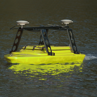
Seafloor Delivers Multibeam Survey ASV to Skanska
survey, upload to the onboard memory and autonomously carry out the survey. The system also provides the ability to manually override the Auto Pilot as well as a return to base function. The EchoBoat-ASV is equipped with a NORBIT iWBMSc (Integrated Wideband Multibeam Sonar, Compact) with internal Novatel SPAN INS and integrated AML real-time SV sensor
Rowe Technologies Appoints Northeast US Agent
they are the largest and longest continuously-run sales rep firm in the northeast serving the oceanographic community.” Founded in 1967 by Bob Warren, ESNE is run today by his son Mark who joined his father in 1977. ESNE counts Kongsberg, Birns, Falmat, Klein, CodaOctopus, Geometrics, Novatel, MetOcean, VideoRay and now Rowe among its vendors. ESNE has also been a Pelican/Hardigg distributor for 25 years
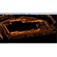
HYPACK Integrates Velodyne Laser
HYPACK informs it has recently worked with the Velodyne HDL-32E topographic laser. Dave Maddock of HYPACK integrated the unit to receive data from all 32 channels. A drive around the local Lowe's hardware store, using a Novatel C-Span RTK-GPS is shown. The Velodyne HDL-32E laser measures 5.7" x 3.4", can be mounted in a variety of angles and generates up to 700,000 points per second with a range up to 70 meters. The new integration will be available shortly as an update to HYPACK 2015.
HYPACK Holds Hydrographic Training Event
Ltd. iLinks Gesolutions LLC Measutronics Corp. Specialty Devices Inc. Kongsberg Underwater Technology Inc. Falmouth Scientific Inc. EdgeTech OGI Inc. R2Sonic Navigation Electronics, Inc. Imagenex Oceanscience Group SonTek Subsea Technologies, Inc. Valeport Ltd. SBG Systems Novatel Inc. AML Oceanographic Seafloor Systems, Inc. Survey Equipment Services L-3 Klein Associates, Inc. (As published in the November/December 2014 edition of Marine Technology Reporter - http://www.marinetechnologynews.com/Magazine

Oceanology International 2014 Exhibitors
National Physical Laboratory Nautikaris B.V. Nautilus Marine Service GmbH Nautronix Limited Navingo BV NCS Survey Ltd Neptune EHF Neptune Sonar Ltd Nexans Norway AS NiGK corporation NKE No Limit Ships B.V. Norbit Subsea AS Norcom Technology Limited Nortek AS Northern Diver Novacavi NovAtel Inc. N-SEA SURVEY B.V. NYMPHEA ENVIRONNEMENT Observator Instruments b.v. Ocean Business 2015 Ocean Modules Sweden AB Ocean Networks Canada Ocean Power Technologies Ocean Tools Ltd Oceanpact Serviços Marítimos Oceanscan - Marine Systems & Technology LDA Oceanscience OceanServ
Compact Bathymetry Sonar: NORBIT Choose NovAtel® SPAN®
NovAtel announce at the Oceanology International (Oi) China expo, that NORBIT has selected their Synchronized Position Attitude Navigation (SPAN) product for integration into the new NORBIT iWBMS Compact Bathymetry Sonar. They say that this combination of technologies produces integrated bathymetry solutions that are easy to operate and deliver previously unattainable miniaturization of the form factor. NovAtel’s SPAN technology brings together Global Navigation Satellite System (GNSS) positioning technology and Inertial Navigation Systems (INS). When coupled with the STIM300, a Micro Electrome
Oceanology International China Program Released
Delivery using a Real-Time 3D Imagining Sonar and Tightly Fused Inertial Navigation Data’ (Blair Cunningham, Coda Octopus Group Inc); and ‘Performance of a Tightly-Coupled GNSS/INS System in a Marine Environment Using MEMS Sensors’ (Mike Mutschler, SEAHORSE Geomatics Inc on behalf of NovAtel Inc) leading up to a short networking break. After the break the afternoon continues with: ‘Hybrid System of Underwater Localization and Communication in Shallow Waters using both USBL and LBL’ (Nicolas Laruelle, OSEAN SAS); ‘Subsea Wireless Telemetry, Standards and Technology