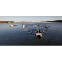
NOAA Taps Woolpert for Chesapeake Bay Watershed Study
(NOAA) to perform hydrographic surveying and collect bathymetric data for hydrodynamic modeling in the Chesapeake Bay Watershed. The $5.5 million award with a $1.4 million option, funded in part by the bipartisan Infrastructure Investment and Jobs Act, is being administered through NOAA’s Office of Coast Survey hydrographic services contract.This project will focus on 615 square nautical miles and include portions of the Potomac, Rappahannock, James, and York rivers, which in some areas have not been surveyed for more than 50 years. Woolpert will mobilize five hydrographic survey vessels, or nearly
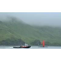
Uncrewed Saildrone to Explore Remote Alaskan Waters
NOAA Ocean Exploration Cooperative Institute partners at the University of New Hampshire in active partnership with Saildrone and MBARI (Monterey Bay Aquarium Research Institute). Additional funding and support comes from the National Oceanographic Partnership Program, NOAA Research, NOAA’s Office of Coast Survey, NOAA’s Deep Sea Coral Research and Technology Program, and the U.S. Geological Survey. This project will support priorities highlighted in the National Strategy for Mapping, Exploring, and Characterizing the United States Exclusive Economic Zone

CTO in Focus: “Stop, Listen & Think” - One-on-One with Shepard Smith, XOcean
technology focused, working on integrating new technology, bringing in GIS and multibeam and database-based systems in through grided bathymetry to speed up our workflows. I also got into the charting side; and I was the chief of our charting division. I finished my career as the Director of the Office of Coast Survey and the U.S. National Hydrographer. Some of my most memorable times were the 10 years that I spent at sea, including four years as the commanding officer of the NOAA Ship Thomas Jefferson. But through it all, I was driving toward bringing new technology to improve the science and art

Shep Smith Appointed XOCEAN CTO
hydrography and nautical cartography.His 10 years of working at sea included tours in Alaska, the Pacific, and the Atlantic and Gulf coasts and four years as the Commanding Officer and Chief Scientist of the NOAA Ship Thomas Jefferson. In his final role with NOAA, he served as Director of the Office of Coast Survey, where he oversaw the US national programs in hydrography and nautical cartography. Smith also represented the United States at the International Hydrographic Organization and regional hydrographic commissions. Smith will be responsible for propelling XOCEAN to its next phase of growth:
NOAA HSRP Public Meet Webinar set for September 1-2, 2021
EST; Sept 2, 2021, 1-5:30pm EST (Time/speakers are subject to change)Register: https://register.gotowebinar.com/register/5627376790601178124The meeting will focus on issues related to hydrographic and navigation services, observations and positioning including topics affecting the NOS’ Office of Coast Survey, Center for Operational Oceanographic Products and Services, National Geodetic Survey, and the University of New Hampshire’s and NOAA’s Joint Hydrographic Center (JHC) and Center for Coastal Ocean Mapping. The HSRP advises the NOAA Administrator on matters that affect marine transporta
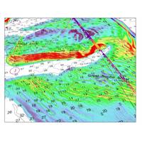
TCarta Delivers Satellite-Derived Bathymetry to NOAA
in the two project pilot areas to enable NOAA to test the use of SDB in shallow coastal zones. This provided updated bathymetry and infilled data gaps from traditional bathymetric measurement technologies, such as airborne lidar or marine sonar. The pilot was conducted jointly by NOAA’s Office of Coast Survey and National Geodetic Survey’s Remote Sensing Division.
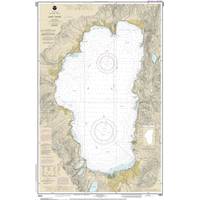
NOAA Begins Transition Exclusively to Electronic Navigation Charts
charts this month, starting with the current paper chart 18665 of Lake Tahoe. After August, NOAA’s electronic navigational chart will be the only NOAA nautical chart of the area.This is the first traditional paper chart to be fully supplanted by an electronic chart as part of NOAA’s Office of Coast Survey Raster Sunset Plan, which includes a new process to notify mariners of the transition of individual paper charts to electronic charts. These charts are easier to update and maintain, keeping mariners safer with up-to-date information on marine hazards.As part of the sunset plan, released
TerraSond Wins NOAA Contract
TerraSond reports it has been awarded its seveth consecutive NOAA contract.The five-year IDIQ contract was awarded by the Hydrographic Surveys Division of the National Oceanic and Atmospheric Administration (NOAA)’s National Ocean Service, Office of Coast Survey, to provide hydrographic surveying services in the USA.The contract was effective January 1, 2020, with a maximum value of $250 million over five years, subject to appropriation by Congress. Thomas Newman, President, TerraSond, said, “Through our NOAA contracts, we have been performing comprehensive site characterization for
NOAA Awards 5-yr Hydrographic Gig to Fugro
(IDIQ) contract by the National Oceanic and Atmospheric Administration (NOAA) to provide hydrographic surveying services in the US.Dutch multinational provider of geo-intelligence and asset integrity solutions said that the contract was issued by NOAA’s National Ocean Service, Office of Coast Survey, to support the creation and maintenance of highly accurate nautical charts.Recognised by NOAA as a top-ranked hydrographic surveying firm, Fugro has worked continuously with the agency on similar IDIQ contracts since 1998.“Over the past 20 years, NOAA has been one of Fugro’s


