USGS : New Topobathymetric Dataset for Potomac River
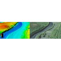
;s 3D Elevation Program (3DEP), with stakeholders including the USGS Earth Resources Observation and Science Center (EROS), National Geospatial Program (NGP), and Eastern Ecological Science Center (EESC) programs, as well as the Interstate Commission on the Potomac River (ICPRB).Using their Teledyne Optech CZMIL SuperNova lidar system Dewberry surveyed 55 miles of the Potomac River from Hancock, MD down to Shepherdstown, WV, acquiring a total of 12.5 square miles of submerged topobathymetric lidar data. The project deliverables included a 3D point cloud and seamless topobathymetric Digital Elevation
Teledyne Geospatial Partners with Seabed 2030 to Study Submarine Impacts of Volcanic Eruption in Tonga
of Products, Teledyne CARIS. “Our partnership with Seabed 2030 and support of TESMaP underscores our commitment to the ocean environment and engaging in projects pursuing greater understanding."Teledyne Geospatial unifies the hardware and software expertise of both Teledyne CARIS and Teledyne Optech. The new group provides customers with innovative integrated solutions. Offerings include turnkey systems, lidar and sonar integrated workflows and a range of systems and solutions that support holistic, precision data collection
Lidar Helps to illuminate the Future of Oceans
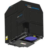
Day webinars and social media reinforced the centrality of oceans for maintaining all life on Earth. Rapidly improving lidar technology and creative, new applications for it represent vectors to achieve that mission. The resulting solutions and discoveries will be as boundless as the seas below.Teledyne Optech launches CZMIL SuperNovaTeledyne Optech and Teledyne CARIS announced their next generation bathymetric lidar, the CZMIL SuperNova, which is touted by the companies as having the best depth performance and the highest green laser point density in its class. Introducing SmartSpacing technology for

Terratec AS Takes Delivery of Next-gen CZMIL SuperNova Lidar Bathymetric Solution
The CZMIL SuperNova combines the deep bathymetric lidar experience of Teledyne Optech with comprehensive processing software from Teledyne CARIS to provide optimized geospatial solutionsTeledyne Optech delivered its next-gen bathymetric lidar CZMIL SuperNova to Terratec AS of Norway, the first private company to acquire the CZMIL SuperNova and the only company in the EU to engage in work around environmental change and coastal zone mapping using the CZMIL SuperNova.CZMIL SuperNova also introduces SmartSpacing technology to enhance efficient point spacing across the swath, onboard processing capability
CZMIL SuperNova Bathymetric Lidar Launched
The CZMIL SuperNova is powered by Teledyne CARIS processing software for creation of seamless topo/bathy data products.Teledyne Optech and Teledyne CARIS, both Teledyne Technologies [NYSE:TDY] companies and global leaders in advanced lidar sensors and marine mapping software, announce their next generation bathymetric lidar, the CZMIL SuperNova.The CZMIL SuperNova boasts the best depth performance and the highest green laser point density in its class. Introducing SmartSpacing technology for even and efficient point spacing, real-time processing capability for reduced post-processing time and configurab
ASI Expands Lidar Portfolio with Teledyne Optech
Teledyne Optech has announced they have signed an agreement with Aerial Surveys International (ASI) to sell a Galaxy T2000, upgrade their existing Galaxy Prime to a Galaxy T2000 and install both sensors in the productivity-doubling G2 Sensor System.This purchase will enhance ASI’s capabilities through the effective 2-million point per second PRF of each Galaxy T2000. Moreover, by combining both sensors on the G2 Sensor System, ASI will bolster their capacity to a true, effective 4 million point per second that provides unmatched point density with the highest available efficiency.The
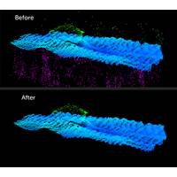
Teledyne CARIS to Display AI Sonar Noise Cleaning Platform at OI
tool is available with CARIS’ HIPS & SIPSTM 11.3 software.At Oceanology International , there will be live demonstrations of noise cleaning using the CARIS Mira AI platform. Visitors to the CARIS booth are invited to “bring the noise” and have their data cleaned on the spot.Teledyne Optech will also be on hand to discuss its marine lidar surveying solutions. Learn about the advantages of the Optech Polaris terrestrial laser scanner that can operate from small watercraft, making it an excellent low-cost tool for mapping shorelines, checking oil rig stability, and surveying the underside
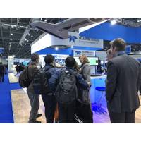
Teledyne Marine: Something for Everyone at OI London
will highlight a full suite of our technologies, including ultra-high-resolution mid-water RESON SeaBat T50-R Extended Range with a built in INS multibeam echosounder, Odom’s new compact single beam echosounder, RD Instruments TASMAN DVL and Teledyne TSS Saturn high accuracy fiber optic INS, Optech TLS-M3 high-resolution laser scanner, PDS and CARIS On-board software, and Benthos new GNSS Survey Feature for easy recovery of acoustic release deployments.Full details here

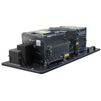
Teledyne Optech Introduces Galaxy T2000
Teledyne Optech, a Teledyne Technologies [NYSE:TDY] company, and leader in lidar sensing has announced the next evolution of its Galaxy platform, the Galaxy T2000. A compact lidar-mapping sensor, the Galaxy T2000 provides a unique feature set for maximum collection efficiency and point density, and is the next step in the evolution of modern aerial surveying. Coupled with a new G2 mounting system, the Galaxy T2000 leverages its compact size to co-mount two sensors over a single aircraft portal, making it quite simply the most flexible commercial lidar system on the market today.The Galaxy T2000


