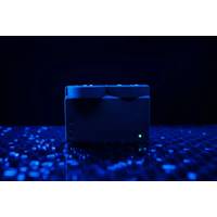
Water Linked Introduces 3D Sonar Technology
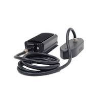
3D-15 is its user-friendly interface, accessible via a web-based browser. This intuitive design simplifies the integration process, eliminating the need for complex software installations. Moreover, its comprehensive Application Programming Interface (API) enables seamless integration with third-party software, enhancing its adaptability and versatility for a wide range of applications.It is partly due to this new 3D sonar technology that Water Linked was selected last November to take part in the NATO DIANA accelerator program. The Defense Innovation Accelerator for the North Atlantic (DIANA) is a
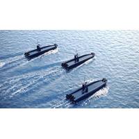
Metal Shark Debuts Prowler Autonomous Vessel and Frenzy Micro-USV
once the surveillance mission concludes.Prowler is equipped with a computer networked system able to support a multitude of UMAA-compliant command and control, autonomy, targeting, and AI software packages. Prowler’s system architecture provides the forward flexibility to accommodate third party software and/or hardware upgrades to support collaborative intercept capability or other technologies as they may be required.Prowler’s computer system, along with propulsion, mechanical and electrical systems are contained within a single removable module to allow for expedited onsite servicing
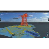
EIVA's Cloud-Based Thin Client Simplifies Sharing and Viewing of Project Data
of Equinor and DOF Subsea - Credit: EIVA Copying over these data sets whenever they must be moved (ie from vessel to USB to PC to colleague to customer) takes time and costs operators and end clients local storage space. Further, some end-clients may not be able to download third-party software to view the results – and therefore miss out on using visualization tools to better understand the data delivered."NaviSuite Cloud users also benefit from NaviSuite project management in the frontend, EIVA siad.According to EIVA, users can manage and share projects with colleagues
Ocean Infinity Orders Six HUGIN AUVs
, making them uniquely placed to deliver data acquisition services at an unmatched scale,” added Richard Mills, Vice President Marine Robotics Sales with Kongsberg Maritime. “They also include the introduction of some new capabilities enabling operators to interface more easily with third-party software and also control adaptive behaviours in response to data collected in-mission.”Josh Broussard, Director of Sub-Surface Technology at Ocean Infinity, said: “These new AUVs include special software interfaces which will allow us to integrate our remote operations technology, mission
TECH FILE: WASSP S3 Gets an Upgrade
Echosounders on the market.The S3 includes an improved IP66 waterproof DRX processor, along with the new RPM processing module and a high performance fairing transducer perfect for pole or hull mounting.WASSP’s own CDX remains the primary UI and interfaces with an even greater range of 3rd party software options such as BeamworX, HYPACK, EIVA, Qinsy, SonarWiz, Echoview and many more. In addition to the standard package, a range of optional licenses are available such as Backscatter, Sidescan and Water Column Targets. In addition to the improvements to the S3, a fully integrated kit known
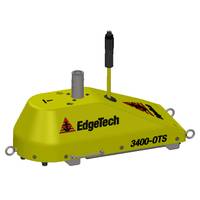
EdgeTech Debuts Pair of Pole Mount Sub-Bottom Profiling Systems
surveys.The lightweight 3400-OTS systems are ideal for shallow water surveys using small boats of opportunity. The sub-bottom profiling systems come as a complete package including EdgeTech’s DISCOVER sub-bottom acquisition & processing software. The 3400-OTS can also be interfaced to 3rd party software
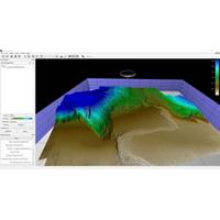
Using High Res 3D Meshes for improved Shape Reconstuction of Marine Survey Data
or multibeam. The primary requirement is that the data is dense enough to support the 3D reconstruction process.Supporting Structure From MotionBefore adding functionality for creating new meshes, Fledermaus supported the importing of meshes created using Structure From Motion (SfM) techniques in 3rd party software, such as Agisoft Metashape and Pix4D. Users desired improvements for better handling of large meshes, and wanted the same functionality they were used to when working with gridded surface. This included operations such as applying color maps, measurement tools, and interactive profiling
MSI completes 'Deepest, Longest Moorings' to Date
buoy to measure meteorology, waves and current profiles as well as an I-type mooring to measure full water column current profiles and water quality.Because the top of the I-type mooring needed to be near the surface, special attention was paid to the mooring design.This was modeled using third party software to ensure that the instruments remain at their intended depths, taking into account the type of rope used for the mooring, as well as the expected metocean conditions on site.Data from the surface buoy is being transmitted in real-time via the Inmarsat DataPro service where it is displayed on
Case Study: 3DSS-DX-450 Sonar
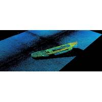
image data is also tagged with position information, ping numbers and time and can also be saved to a catalog for later manipulation. Since the saved data is three dimensional, additional views and measurements can be made, color scales adjusted and results can be exported for import into 3rd party software. Conclusion The wreck of the J.E. Boyden has been imaged using a new 3D sidescan technology introduced by Ping DSP that provides geometrically correct high resolution three dimensional imagery and provides a significant step forward in comparison with conventional 2D sidescan imagery


