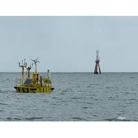
Weather Data Gathering Project Underway for US Offshore Wind
Energy Program. “We want to use these insights to improve NOAA’s operational weather prediction models, which often serve as the foundational forecasts for the energy community in their daily management of their wind plants.”Over the last three months, researchers have deployed remote sensing instruments, offshore buoys, and towers at various locations off the coasts of Massachusetts, Rhode Island, and Long Island - home to Vineyard Wind, Block Island Wind Farm, South Fork Wind Farm, and seven other lease areas. The instruments will collect real-time data on a wide range of weather-related
Wreck of WWII-era Cargo Ship Found in the Great Lakes
The wreck of a World War II-era freighter has been discovered in over 600 feet of water around 35 miles north of Michigan’s Keweenaw Peninsula.Over the last 7 years, shipwreck researcher Dan Fountain has been studying remote sensing data in the search for shipwrecks in Lake Superior. After coming across a particularly deep anomaly, he reached out to the Great Lakes Shipwreck Historical Society (GLSHS) for help in identifying the potential wreck. In 2023 GLSHS Director of Marine Operations, Darryl Ertel, Fountain and crew of the R/V David Boyd, towed a Marine Sonic Technology side-scan sonar over
HydroSurv Funded to Commercialize Robotic Seagrass Solution
designated worksites on the south west coast of England, conducting baseline and seasonal re-survey work and ultimately delivering some 40 days of on-water testing and data, showing seasonal variation over the project’s 9-month duration.Dubbed SONARS (Seagrass Observation using Novel Acoustic Remote Sensing), the project will see HydroSurv work with Coastal Marine Applied Research (CMAR) from the University of Plymouth, the Ocean Conservation Trust, Falmouth Harbour and the South Devon Area of Outstanding Natural Beauty.The technology package has already significantly advanced seagrass mapping capabiliti
Ocean Engineers and Scientists Share Ideas, Challenges at International Arctic Workshop
enables a 25-year engagement among the governments, academia, and industry of the U.S., Canada, Denmark, Finland, New Zealand, Norway and Sweden. The MOU can be used to address various areas of interest including polar environmental modeling, prediction, and information sharing; polar sensors and remote sensing techniques; polar communications and situational awareness; platform design and performance for polar environments; research, development, test and evaluation (RDT&E) infrastructure for polar environments, experimentation and demonstrations for polar environments; and operational research
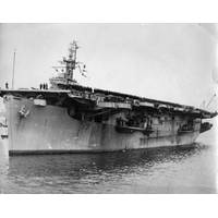
Wreck Site Identified as WWII Carrier USS Ommaney Bay (CVE 79)
when the torpedo warheads on Ommaney Bay finally went off.Ommaney Bay received two battle stars for her World War II service.The wreck of Ommaney Bay is a U.S. sunken military craft protected by U.S. law and under the jurisdiction of the Department of the Navy. While non-intrusive activities, such as remote sensing documentation, on U.S. Navy sunken military craft are allowed, any activity that may result in the disturbance of a sunken military craft must be coordinated with NHHC and, if appropriate, authorized through a relevant permitting program. Most importantly, the wreck represents the final resting
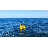
LiDAR Buoys Deployed to Capture Data for Two Scottish Floating Wind Farm Proejcts
offshore wind projects proposed by the BlueFloat Energy and Renantis partnership.A couple of days ago, the two EOLOS FLS200 LiDAR buoys were deployed at the partnership’s Broadshore site 50 km north of Fraserburgh and the Bellrock site 130 km east of Aberdeen.Equipped with fully autonomous and remote sensing devices, the buoys will remain onsite for at least 12 months to capture accurate wind, metocean and atmospheric data and obtain insights on the site characteristics, which will help shape and inform the design of the wind farms.“This is another exciting step for our Broadshore and Bellrock
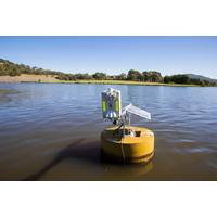
CSIRO Aims to Create a 'Weather Service' for Water Quality
; Hunter Water; universities and research organizations including ANU Institute for Water Futures; ANU Fenner School of Environment and Society; Curtin University; La Trobe University (Cisco-LTU Centre for AI and Internet of Things); University of Queensland (Reef Catchments Science Partnership, Joint Remote Sensing Research Program and Remote Sensing Research Centre); and international collaborators including CSIRO Chile; Hanoi University of Mining and Geology; Swinburne University of Technology Sarawak Campus; University of California, Davis; University of California, Merced; Vietnam’s National Center
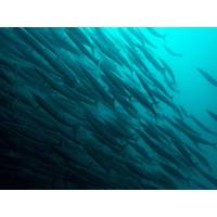
Simple-to-use eDNA Test Will Help Track Marine Species
to understand climate change and ocean acidification impacts on fisheries and marine ecosystems, map endangered and invasive species, characterize harmful algal blooms, and explore our oceans” Gold said. “eDNA has the potential to revolutionize biology and resource management in the way remote sensing revolutionized agriculture, oceanography, hydrology, and weather forecasting. As with remote sensing and satellite technology, NOAA along with our federal partner agencies is helping lead the way on utilizing eDNA at scale”

Hearing the Light: DAS could Revolutionize Subsea Defense
influence subsea defense. With a low-cost, low-maintenance, ready-made sensor network already in place throughout the world’s oceans, DAS will likely soon find its way into the defense inventories of friends and adversaries alike.Source† Railey, K; DiBiaso, D; Schmidt, H. An acoustic remote sensing method for high-precision propeller rotation and speed estimation of unmanned underwater vehicles, The Journal of the Acoustical Society of America. 2020, 148, 3942.About the Author: David R. Strachan is a defense analyst and founder of Strikepod Systems, a research and strategic advisory focusing


