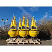
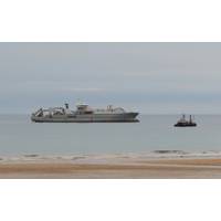
OSIL Dredge Monitoring Buoy Network for Van Oord
will support dredging operations by providing continuous real-time information about the dredge plume and surrounding environmental conditions.The buoys are equipped with water quality sondes provided from Van Oord’s existing equipment pool, and relay collected data via GSM with an Iridium satellite Short Burst Data (SBD) back up. The systems are self-contained, being furnished with sufficient solar power (which can be combined with alternative power sources) and back-up batteries to sustain the power demands of the systems. Data can be relayed from the buoys immediately and securely
US Aims to Improve Ocean Observations with $2.7 Million for New Robotic Floats
that measure ocean and climate data.The Argo array is made up of a fleet of robotic instruments that measure temperature and salinity in the global ocean, drifting freely with the currents. Every 10 days, an Argo float dives 1.2 miles below the surface to collect data, which it then transmits via satellite after it returns to the surface for use in weather forecasts and climate research.“For 25 years, the Argo Program has provided more ocean data than any other observing instrument, helping NOAA revolutionize our understanding of the ocean and its role in Earth’s climate,” said
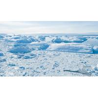
Artificial Submarine Curtains Won’t Save West Antarctica’s Retreating Glaciers
Embayment is the sector of West Antarctica currently losing most ice. NASA Earth Observatory, CC BY-SAThis warm water drives some of the highest rates of ice-shelf melting seen on the continent and is causing the ice to thin and retreat rapidly. Recent research suggests this retreat is now unavoidable.Satellite observations have shown extensive thinning and retreat of glaciers in this region. Some scientists are concerned that this sector has already passed a threshold for irreversible retreat.The Amundsen Sea Embayment has been identified as the most vulnerable sector of the ice sheet because the glaciers
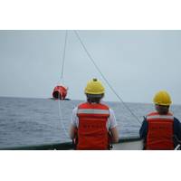
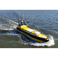
Sulmara on Offshore Survey Job at Bayou Bend CCS Scheme in Texas
offshore platform locations, which has the potential to reduce emissions from regional industrial facilities by safely storing carbon dioxide underground.Sulmara utilised an electric WAM-V 16 USV for the offshore data acquisition. The collaborative project also utilized the SpaceX-backed Starlink satellite system to ensure strong communications between the shore and the USV. “The quality of the data gathered is some of the best we’ve seen from a USV. That quality of information, as well as the operability of the equipment and relationship that has been developed, have been key to
Undersea Cables: The Unseen Backbone of the Global Internet
suggested amending international laws around cables to deter foreign sabotage and developing treaties that would make such interference illegal.The recent Red Sea incident shows that help for these connectivity challenges might lie above rather than below. After cables were compromised in the region, satellite operators used their networks to reroute internet traffic. Undersea cables are likely to continue carrying the vast majority of the world’s internet traffic for the foreseeable future, but a blended approach that uses both undersea cables and satellites could provide a measure of protection
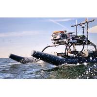
Chance Maritime Technologies' MC-29 USV Completes Long-endurance Testing
days, which included 24 operational days of 24-hour operation in Vermilion Bay and the Gulf of Mexico.This new class of utility vessel offers kilowatts of continuously available payload power, 30+ day endurance, a 19” payload rack, moon pool, active gyro stabilization, and high-bandwidth Starlink satellite communications.Stuart Chance, CEO of Chance Maritime Technologies, said, “We’re extremely excited with the results of our endurance testing. The MC-29 represents an incredible effort by the talented team at Chance Maritime to design, build, and operate a flexible, durable and truly
Kongsberg Discovery Launches HiPOS – HiPAP Positioning Software
vessels. The software essentially splits the workload of Kongsberg Discovery’s HiPAP systems, with the positioning and processing managed onboard the vessel processor, while a client user interface is run remotely over a lower bandwidth VPN connection. The remote connection can be via satellite, 4G, 5G or Maritime broadband radio.The user interface can also be operated directly on the vessel, as in a traditional setup, whilst at the same time having the option for shore-based operators to log in and take over for a shift, or provide expert support.Spencer Collins, Vice President for Sales
Kongsberg Discovery Launches Seapath 385 Navigation System
with the release of Seapath® 385, a system combining new hardware and advanced navigation algorithms to unlock optimal precision for hydrographic surveying.Seapath 385 combines inertial technology and processing algorithms with multi-frequency GPS, GLONASS, Galileo, Beidou, QZSS and geostationary satellite signals. The system integrates raw inertial sensor data either from Kongsberg Discovery’s high performance MGC® (Motion Gyro Compass) or MRU (Motion Reference Unit), together with GNSS data, and RTK, PPP or DGNSS corrections.The result is an integrated, robust and highly accurate solution
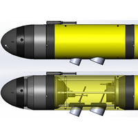
Teledyne Integrating the Kongsberg EK80 WBT Mini Into Its Slocum Gliders
.The Slocum Glider is the world’s most prolific autonomous gliding platform, a subsea vehicle that uses changes in buoyancy to efficiently move through the water, allowing it to persistently monitor the ocean water column for months at a time, and transmit gathered data shoreside via an iridium satellite connection. Slocum Gliders are used across a wide-ranging set of missions, including deployments serving Oceanographers, Fisheries, Energy Producers, and Military customers.Rendering of Teledyne Slocum G3s Glider with Kongsberg WBT Mini EK80 Integration (Image: Teledyne Marine)The EK80 integration


