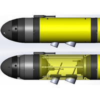
Teledyne Integrating the Kongsberg EK80 WBT Mini Into Its Slocum Gliders
Slocum Glider is the world’s most prolific autonomous gliding platform, a subsea vehicle that uses changes in buoyancy to efficiently move through the water, allowing it to persistently monitor the ocean water column for months at a time, and transmit gathered data shoreside via an iridium satellite connection. Slocum Gliders are used across a wide-ranging set of missions, including deployments serving Oceanographers, Fisheries, Energy Producers, and Military customers.Rendering of Teledyne Slocum G3s Glider with Kongsberg WBT Mini EK80 Integration (Image: Teledyne Marine)The EK80 integration
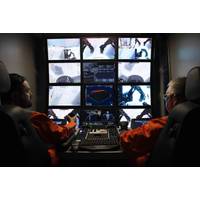
Remote Operations: Challenges & Opportunities
, microphones, audio, and display screens but with the added advantage of all parties having access and being highly familiar with how to use them. Specialist software applications can be installed on mobile devices to facilitate real-time live video and audio streaming over any network. The Satellite Connection – Overcoming the Challenges In its March 2023 report, Verified Market Research revealed that by 2028, the value of the global maritime satellite communication market could swell to an estimated $6.67B. While that figure is impressive, challenges are still prevalent today
Two Century Old Shipwrecked Whaling Ship Discovered in GOM
Native Americans prospered in the ocean economy despite facing discrimination and other injustices. It is also an example of how important partnerships of federal agencies and local communities are to uncovering and documenting our nation’s maritime history.”With guidance provided via satellite connection from partner scientists on shore, a team aboard NOAA Ship Okeanos Explorer piloted a remotely operated vehicle (ROV) to explore the seafloor on February 25, 2022, at a suspected location first spotted by an energy company in 2011 and viewed briefly by an autonomous vehicle in 2017, but never
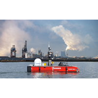
Fugro Deploys Uncrewed Surface Vessel in The Netherlands
Dutch offshore services firm Fugro will dispatch its Blue Essence, an offshore uncrewed surface vessel (USV) with an electric remotely operated vehicle (eROV), on its first project in the Netherlands.During operations, the vessel is controlled from an onshore remote operations center (ROC) via a satellite connection and will be used for the inspection of offshore assets, construction support services, and hydrographic and geophysical surveys."USVs play an important role in the future of the maritime sector by improving safety, reducing carbon emissions, and delivering data more efficiently. USV operations
Subsea Technology and the New Routes to Residency
on board moving to a situation where they are onshore.”Bandwidth, regulatory and HR challengesThe transition to remote and autonomous operations also brings connectivity challenges, he adds, Fugro’s ROCs are equipped to facilitate the required bandwidth, uptime and reliability of the satellite connection, which is key to safe operations and effective data delivery To enable smooth operations upon delivery of the first systems, Fugro has taken up a front running role in developing the legal and operational framework, maritime regulations, etc. They are working together with regulatory
Hydrographic Survey Vessel to be Converted for Unmanned Operations
on-board payloads (including survey sonars, hydrophones, winches, cranes and davits) from its shoreside Survey Control Room, which has been equipped to facilitate several multi-beam surveys simultaneously. Deep will then transfer all collected data from the vessel to the control room via 4G and satellite connection. The combination of Sea Machines’ technology and the Survey Control Room will enable Deep to transition from minimally manned missions to unmanned missions in the near future.“Sea Machines systems are an ideal fit for commercial marine operations that require high levels of predictabili
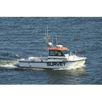
USV Completes Greater Gabbard Survey
(USV), owned and operated by XOCEAN, carried out seabed surveys on seven of the turbines at the 140-turbine Greater Gabbard offshore wind farm, located 23 kilometers off the UK coast.The USV is around 4.5 meters long and weighs about 750 kilograms, and can be monitored and controlled 24/7 via a satellite connection by a team at an onshore control center.Throughout the survey, the data collected was monitored from shore in real-time by experts located in the UK, to validate data collection before the vessel departed the work locations. This demonstrates the highly flexible and collaborative nature of
Bureau Veritas Aproves IoT Platform Fleet Data
Fleet Xpress and is soon to be rolled out to Inmarsat FleetBroadband users.The Fleet Data IoT platform draws on different sources for data, including onboard sensors, the ship’s voyage data recorder (VDR) or the Integrated Automation System. Data is pre-processed and transferred ashore by satellite connection. Users access a secure online dashboard that is virtually connected via Application Program Interfaces (APIs) to the analytic, monitoring and management tools available through the IoT.“The launch of Fleet Data indicated that the world’s leading maritime satcoms supplier had also
Remote Monitoring System Delivered for The Ocean Cleanup
scores of sensors. This data relates to navigation, environmental conditions, the system’s operational status and its integrity. The sensors are linked to five solar-powered electronic pods, which will be mounted on the barrier. The pods communicate to each other via a WiFi mesh network and satellite connection, enabling The Ocean Cleanup to monitor its system remotely and retrieve data in real time – including images and GPS locations – from its headquarters in Rotterdam, the Netherlands.Seatools performed an extensive engineering trajectory on behalf of The Ocean Cleanup. Conscientious