
PODCAST: “All in the [Gallaudet] Family”
that career path in the Navy is you get exposed to ocean technologies from the very beginning. Even at the Naval Academy, we were using side-scan sonar to do surveys and collect data in the Chesapeake Bay.My first tour was going to graduate school at Scripps where I worked with multibeam sonar and satellite imagery. I went on a few cruises on a couple of Scripps ships, and then I immediately deployed to the Arabian Gulf and worked on a hydrographic survey ship, towing side-scan sonar and operating multibeam sonar, and using other types of collection equipment like conductivity, temperature and depth profilers
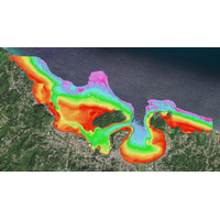
TCarta Plans Bathymetric Mapping Workshop for Jamaica
expertise, so that we can use these tools more flexibly.”This year’s workshop seeks to produce SDB maps of the entire coastal area of Jamaica, including the environmentally and economically important Pedro Cays. Participants will extract seafloor depth data from multispectral Sentinel-2 satellite imagery and use NASA ICESat-2 LiDAR data for validation. The resulting data sets will include water depth measurements at 10-meter resolution to an average depth of 20 meters.“The 2024 workshop will be led by hydrographers from TCarta’s Colorado and Jamaica offices,” said Goodrich
U.S. Revives Cold War Submarine Spy Program to Counter China
reviewed hundreds of Navy contracts. That examination identified at least 30 deals linked to the surveillance program signed over the last three years with defense giants as well as a string of startups working on unmanned sea drones and AI processing. A Reuters review of ship-tracking data and satellite imagery also revealed new details about the Navy’s secretive underwater cable laying.The IUSS is led by Captain Stephany Moore, a veteran Navy intelligence officer. The program operates under the command of Submarine Force U.S. Pacific Fleet, headed by Rear Admiral Richard Seif.Moore and
Inside the Subsea Cable Firm Secretly Helping America Take on China
;s home to a discreet U.S. naval base.Over the next month, the ship’s crew covertly laid an underwater fiber-optic cable to the military base, an operation code-named “Big Wave,” according to four people with direct knowledge of the mission, as well as a Reuters analysis of satellite imagery and ship tracking data.The new super-fast internet link to Diego Garcia, which has not previously been reported, will boost U.S. military readiness in the Indian Ocean, a region where China has expanded its naval influence over the last decade.The CS Dependable is owned by SubCom, a small-town
TCarta to Deliver Satellite Derived Bathymetry for 13 Regions
and seafloor classification data for the coastal zones of 13 regions around the world to the National Geospatial-Intelligence Agency (NGA) under contract to Maxar Technologies.TCarta will deliver seabed depth and feature maps from high-resolution multispectral Maxar WorldView-2 and WorldView-3 satellite imagery for the 13 regions. SDB measurements are accurate to depths of 20-30 meters depending on water conditions, with two-meter spatial resolution. Feature classification includes coral reefs, large rocks, sandbars and other navigation hazards.TCarta has processed thousands of Maxar satellite images
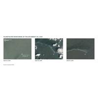
NOAA Taps Planet to Track Oil Spills, Marine Debris, And Marine Life
Satellite imagery company Planet is providing data to the National Oceanic and Atmospheric Administration (NOAA) who are leveraging the company's PlanetScope and SkySat products to gain oceanic insights by evaluating oil spills, tracking marine debris, detecting vessels, and identifying large marine mammals like whales.In 2004, Hurricane Ivan caused severe damage in the Gulf of Mexico, including the collapse and sinking of an oil platform. Crude oil from this platform continued to leak for over a decade, in what would become the longest running oil spill in United States history. NOAA began
Seabed 2030 Enters Partnership with Terradepth
marine data sets onto the secure platform as well as access the thousands of ocean data files currently included in the platform database – side-scan sonar, synthetic aperture sonar, multibeam bathymetry, satellite-derived bathymetry, LiDAR, sub-bottom profiles, magnetometer readings, and satellite imagery.Absolute Ocean also serves as the data delivery platform for the geophysical and hydrographic survey solutions Terradepth offers to a rapidly growing client base in the Environmental, Telecommunications, Construction, Energy, and Maritime industries. To capture seafloor data for these commercial
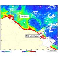
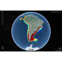
First North Brazil Current Ring of 2022 Forms Offshore Suriname and French Guiana
eastern Suriname (Figure 1). The ring is oriented northwest to southeast, is 520 km across, and spans water depths from 50 m to 5,000 m. Following separation, the NBC Retroflection reformed 100 km southeast of Sylvia.EddyWatch Team Monitors Ring SylviaWHG’s EddyWatch team utilizes satellite imagery, drifting buoys, and rig-mounted current meters to monitor the location and current intensity of NBC rings. Over the next couple months, Ring Sylvia will migrate westward to west-northwestward along the coastline of Suriname and Guyana and impact active oil and gas facilities in the area. WHG
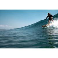
What is the Value of a Wave?
economic contribution of surfing is in the order of hundreds of millions of dollars. This in terms of surfers’ welfare, as well as direct spending on surf gear and travel.Surfers in Noosa (© William / Adobe Stock)Overseas, the economic contribution is a little clearer. A 2017 study used satellite imagery to demonstrate that economic activity grows faster near good-quality surf breaks, particularly in developing countries such as Indonesia and Brazil.In the UK alone, the overall annual impact of surfing on the national economy is calculated at up to £5 billion (over A$9 billion).How coastal


