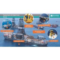
Digital Ocean: Making Subsea Data More Easily Accessible
center around achieving efficiency of operations and the use of smaller vessels. For example, the introduction of autonomous surface vessels (ASVs) will represent a culture change, with operator safety cases relying on redundancy and fallback systems to control vessels in the event of satellite navigation failure or error. Other challenges include the introduction and successful uptake of collision avoidance systems. Sonardyne is able to provide a complete suite of integrated systems required for marine autonomy. Platforms such as its AvTrak 6 instrument, which is optimized for
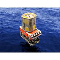
C-Innovation ROVs inks deal with Sonardyne
requirements. SPRINT uses Honeywell ring laser gyroscopes (RLG) and accelerometers with a 20+ year proven track record. The particular RLGs used are the standard inertial sensors supplied to almost all commercial aircraft and have also been widely used for military aircraft, vehicles and satellite navigation with a proven reliability track record.
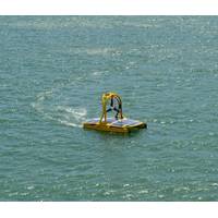
NOC Buys Two Ocean Robot Boats
; the robot boats harvest energy from the environment. The AutoNaut vehicle is powered by wave energy while C-Enduro is driven by wind power. Both boats use solar energy to power instruments. The designs exploit developments in technology that allow for data to be transferred to shore and satellite navigation tools to control and change their position. “The intention is that the vehicles will complement, and eventually replace, traditional data-collecting fixed moorings deployed in the open ocean. It really is the way forward for ocean research” continued Geraint West. The scheme
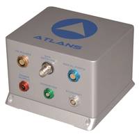
iXBlue and Septentrio Create ATLANS-C
iXBlue, a leading provider of navigation, positioning, and mapping solutions, today launched its new ATLANS-C position and orientation system, developed in close cooperation with Septentrio Satellite Navigation. The system is designed to provide continuous and accurate positioning in urban environments, where global navigation satellite system (GNSS) signals are obscured, intermittent, or possibly distorted by reflective surfaces. ATLANS-C benefits from the optimized integration of iXBlue’s leading fiber-optic gyroscope (FOG) based inertial navigation system (INS) and Septentrio’s

Oceanology International 2014 Exhibitors
Technology GmbH Seabed BV Sea-Bird Scientific SeaBotix Inc. SEACON (europe) Ltd Seamor Marine Ltd. Seascape Seatronics Ltd Seaview Systems, Inc. SeeByte Ltd SEISMIC ASIA PACIFIC PTY. LTD Senlution Technologies, China Sensonor AS Sensor Technology Ltd Sensorlab SL SENSYS Septentrio Satellite Navigation Sercel Sidus Solutions LLC SIG Silicon Sensing Systems Ltd Siri Marine SMC Ship Motion Control SMD Ltd Society for Underwater Technology Society of Maritime Industries Sonar Equipment Services Ltd Sonardyne International Ltd SonarTech Co., Ltd Sontek Sound Metrics Corp. South
TeamSurv Ocean Survey Project Boosted
TeamSurv, the crowd sourcing project to create better nautical charts, has won support and endorsement from the European Space Agency (ESA) and the European Satellite Navigation Competition (ESNC). TeamSurv has won a call by ESA to enter their Business Incubation Centre (BIC) at Harwell, Oxford. This provides TeamSurv with finance, with business and technical support, and with office space for the next year to enable a plan for a sustainable future, and to grow with the number of vessels and the amount of data produced. ESA’s Technology Transfer Programme Office has seven BICs across Europe
Russian Icebreaker to Norway for Upgrade
waters in the region. As previously reported, Russian authorities last year confirmed that Russian seismic studies would start in 2012 . Norway started the mapping of is part of the newly delimited waters in summer 2011. The upgrade of the “Dikson” will include the installation of satellite navigation equipment, as well as all necessary equipment for the seismic works, Kuzmin says. The vessel will head to sea at 1 August and return to its home base in late September or early October. It is the first time Russia uses its diesel-run icebreaker for this kind of operations. For several years