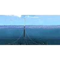
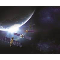
Fugro, Partners Design Mooring Line Fatigue Tracker for Floating Wind Turbines
offshore,” Fugro said Monday.As a future part of the UK’s green energy generation portfolio, floating offshore wind farms will need to operate reliably and minimize in-person inspections to reduce HSSE risk exposure and remain cost-effective, Fugro said.Drawing on its existing satellite positioning, structural and metocean monitoring systems, Fugro worked with AS Mosley and the University of Strathclyde to combine a physics-based simulation model with fatigue analysis to develop a cost-effective and streamlined methodology. "Instead of the current conventional 5-year subsea
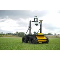
Robotics Community Gains Access to Xsens IMUs
help them develop innovative designs at a lower cost and with enhanced functionality.’The MTi-series of IMUs is a broad portfolio of products including IMUs, Vertical Reference Units (VRUs), Attitude and Heading Reference Systems (AHRS) and Inertial Navigation Systems (INS) with or without satellite positioning data.The Xsens IMUs are particularly well suited to systems based on Clearpath Robotics development platforms: the IMUs offer native support for the open-source Robot Operating System (ROS), while Clearpath Robotics is a recognized authority on ROS technology, and its robot platforms are
NASA, Norway to Develop Arctic Laser-Ranging Station
, the basis for setting coordinates for all locations on Earth’s surface. The reference frame is used to measure the position of objects in space with respect to the Earth, as well as to precisely monitor motions of Earth’s crust, changes in sea level, and to support satellite positioning technology like GPS, which is used in many aspects of our daily lives. “From the NASA perspective, laser ranging is important to understanding where our spacecraft are, as well as where on Earth their measurements are located,” said Stephen Merkowitz, space geodesy project
MTR100: Kongsberg Maritime
“The Full Picture.” The company delivers a wide range of systems for subsea survey and construction, maritime security, environmental monitoring, dynamic positioning and navigation systems, marine automation, safety management, cargo handling, maritime simulation and training, satellite positioning, naval sonar systems, fishery research and catching systems, underwater mapping systems and marine robotics. The Norway based company has a global presence, with 55 offices in 18 countries, including manufacturing locations in Canada, China, Germany and several in the U.S., U.K.
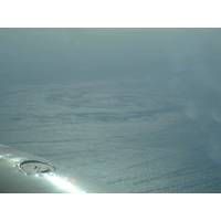
Innovative New System Delivers Surface Current Data
of digital camera technology and highly accurate positioning systems, together with advanced algorithms, to derive surface currents from wave spectra measurements. It can be installed on a suitable survey aircraft, together with an inertial navigation system augmented by Fugro’s Starfix satellite positioning system. Current data are reviewed in real-time on board the aircraft, providing continuous assessment of data quality and the location of strong currents. Within an hour of the aircraft landing the system produces a “quick-look” map of the currents over the area while
Fugro Awarded a Three-Year Positioning Contract by PGS
Fugro has been awarded a three-year contract by PGS for the provision of precise satellite positioning systems for its entire seismic vessel fleet. PGS is a global provider of marine seismic and electromagnetic services, data acquisition, imaging, reservoir services and multi-client library data. Fugro, a provider of precise satellite positioning to the offshore oil and gas industry, will supply PGS vessels with a number of completely independent Global Navigation Satellite Systems (GNSS). These systems include Fugro’s recently launched Starfix.G4 - the first commercial
2G Robotics Delivers to Oceaneering
2G Robotics delivered two deep-rated ULS-500 subsea laser systems to Oceaneering International, Inc.'s business unit, Oceaneering Survey Services (C&C Technologies), a provider of deepwater seafloor mapping services, subsea surveys and satellite positioning. Including these two ULS-500 systems, Oceaneering now uses six of the ULS-500 systems with its AUVs as part of its advanced survey and inspection services for assessing pipeline and flowline integrity. Oceaneering has been using the ULS-500 since 2013 to perform dynamic flowline and pipeline inspections with its AUVs.
MTR100: Kongsberg Maritime
research • Dynamic positioning and navigation systems • Marine automation • Safety management • Cargo handling • Maritime simulation and training • Satellite positioning Integration of systems is a key driver to the success of Kongsberg Maritime. The Company is dedicated to providing innovative and reliable solutions for all customers and stakeholders that ensure optimal operation at sea and onshore. Market Segments Key markets are countries with
Ultra-High Accuracy G2+ Positioning Service
algorithms to generate precise corrections which are used to augment the standard signals broadcast by GPS and GLONASS satellites. Customers receive corrections via seven high-powered communications satellites, providing at least two independent G2+ data sources. According to Fugro, the new satellite positioning service will be particularly beneficial when seeking to measure latitude, longitude, elevation and speed with high accuracy in real-time. www.fugro.com (As published in the APRIL 2015 edition of Marine Technology Reporter - http://www.marinetechnologynews.com/Magazine


