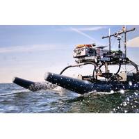
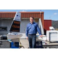
Sulmara on Offshore Survey Job at Bayou Bend CCS Scheme in Texas
offshore platform locations, which has the potential to reduce emissions from regional industrial facilities by safely storing carbon dioxide underground.Sulmara utilised an electric WAM-V 16 USV for the offshore data acquisition. The collaborative project also utilized the SpaceX-backed Starlink satellite system to ensure strong communications between the shore and the USV. “The quality of the data gathered is some of the best we’ve seen from a USV. That quality of information, as well as the operability of the equipment and relationship that has been developed, have been key to the
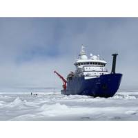
UAF’s GINA Provides a Guiding Hand in Arctic Ocean Research
that travel through clouds, bounce off the Earth’s surface and return to the sensor.Data from each type of sensor can be processed into different products for different uses.GINA uses data from passive-sensor satellites in the National Oceanic and Atmospheric Administration’s Joint Polar Satellite System.Acquiring imagery through the GINA system in Fairbanks enhances the usefulness of Roberts’ map server. Although the map server relies heavily on cloud-penetrating SAR imagery that shows the ice in great detail, SAR satellites image the same area just once every day or less often. Such
NASA’s JPL Using Teledyne Marine APEX Profiling Floats
about 15 miles of where they were deployed, meaning that the strategy of parking them on the sea floor has largely worked so far. One float, deployed in Melville Bay was initially unable to surface and transmit data in the ice covered environment, but was finally able to connect to the Iridium satellite system and transmit all data that that had been collected and stored up to that point.Now that the floats are operational they could potentially continue transmitting data over a winter season or more. For example, in order to extend their lifetime, the profiling cycle times between surfacings has
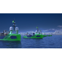
Sonardyne's Sensors for Ocean Infinity's Armada USV Fleet
vehicles (USV).Sonardyne said Wednesday it would provide the first wave of Ocean Infinity’s new Armada fleet with key sensor technologies for underwater platform navigation, tracking, control, and communications, as well as ensuring uninterrupted surface navigation, even when global navigation satellite system (GNSS) services are degraded or denied.The low-emission robotic fleet will initially see 17 bespoke designed uncrewed vessels added to Ocean Infinity’s existing robotics fleet.Ocean Infinity Launches ArmadaThe vessels will be able to perform offshore data acquisition and intervention in
NovAtel Unveils Oceanix Nearshore Service
NovAtel, a OEM supplier of high precision Global Navigation Satellite System (GNSS) positioning technology, has unveiled its Oceanix Nearshore correction service at Ocean Business in Southampton, UK. Oceanix Nearshore, a subscription-based GNSS correction service for Precise Point Positioning (PPP), provides sub-decimetre positioning for marine applications such as dredging, hydrographic survey, mapping and coastal patrolling. The robustness of Oceanix infrastructure sets it apart from the competition. Oceanix precise corrections data is generated utilizing a network of over 80 strategicall
Fugro Awarded US Government Survey Work
integrated data collection and processing in support of the USACE’S National Coastal Mapping Program. Other services within the scope of this IDIQ contract include photogrammetry, vessel based hydrographic surveying, topographic and boundary surveying, conventional and Global Navigation Satellite System (GNSS) surveying, terrestrial and mobile LiDAR scanning and geographic information system (GIS) development and production
Sailbuoy Takes Off
. So, can you tell us a bit about the Sailbuoy? The Sailbuoy is the world’s first long endurance autonomous sailing vessel. It navigates autonomously and uses wind power for propulsion. Data communication and navigational control is in real-time using the Iridium satellite system through a user-friendly system that requires limited user input. The vessel is designed for relatively long term missions (several months to a year), robustness and cost-efficiency. The standard Sailbuoy has a length of 2 m, a displacement of 60 kg, a payload of 15 kg and 30W solar panels. The
Deep Side to Chilean Devil Rays
patterns of 15 Chilean devil rays in the central North Atlantic Ocean during 2011 and 2012. The tags, which stay on the animals for up to 9 months, also measure water temperature, depth, and light levels of the waters. Once the tags pop off, they float to the surface and beam data via the ARGO satellite system back to computers on shore. Devil rays, which can grow as large as four meters (13 feet) across, are ocean nomads travelling large areas of the ocean. Dive data from the tags showed individuals also routinely descended at speeds up to 6 meters per second (13.4 miles per hour) to depths of
PSAT Used for Trout Study on Lake Superior
values. On the programmed date the tag will pop off the fish, float the surface and transmit its location via satellite. The researchers will then attempt to locate and recover the tag, when practical, to download the raw sensor recordings. Otherwise the data will be transmitted through the Argos satellite system.


