Marine Telemetry: Shedding Light Below the Waves
manta rays, but also data deficient and lacking the extensive management necessary. While her research started as underwater visual surveys, Cullen has been able to delve into telemetry in the past few years, inspired by other southern African marine researchers.Cullen utilizes both acoustic and satellite telemetry to increase understanding of species movement. Satellite tags provide a wide range and more data, while acoustic tracking enables researchers to hone in on an important area to track finer scale movement during a longer period. Furthermore, each species requires a different telemetry method

Royal Navy on Target with MASS Simulation System
ranges and the necessity to destroy physical targets on land or at sea.The free-floating system consists of a set of operation buoys, which report acoustic event data, point of impact, and precise time. The acoustic event data is sent to a base station receiver using overthe-horizon Iridium satellite telemetry or UHF line-of-sight radio, this allows MASS to measure indirect fire. Real-time results are viewed and analyzed both on-ship and at land-based command posts.“MASS is the future of naval gunfire training,” said Tony Chedrawy, President & CEO, MetOcean Telematics. “Its
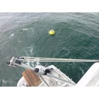
New Drifter Buoy Tracks Water Currents
MetOcean Telematics has developed the STOKES Iridium tracking drifter, a compact drifting buoy designed and tested in technical partnership with Florida State University (FSU) that tracks water currents at the surface.The small light-weight buoy is equipped with Iridium satellite telemetry, GPS positioning and a sea surface temperature sensor. Iridium satellite telemetry enables the buoy to provide vital sensor and geo-positional location data in real time. Iridium also allows the buoy to have bi-directional capabilities. This is a critical ability, for example, if the buoy enters a region of interest
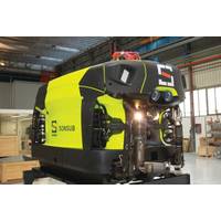
Subsea IMR Moves Robotic
In a defense-focused demonstration Teledyne Seabotix ROVs were operated from Marine Advanced Research WAM-V USVs. In commercial practice, SAAB ROVs have been supported by L3 ASV C-worker USVs. In these configurations the objective is primarily inspection. An operator ashore, connected via radio or satellite telemetry, can use the combined systems to examine structures or the seafloor. Light intervention is feasible but typically the ROVs involved lack the physical power to engage core offshore maintenance tasks. Operations of this kind are typically measured in hours, or perhaps a few days, but not intended
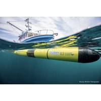
Kongsberg to Market Two New Underwater Gliders
water, they use fixed wings and changes in buoyancy to achieve both vertical and forward motion. The vehicles move through the water in a saw-tooth trajectory and surface periodically to communicate data on water properties, such as temperature, salinity and oxygen concentration, back to users via satellite telemetry. This form of propulsion is very energy efficient, and allows mission periods of several months and distances of thousands of kilometers, rather than just a few days and tens of kilometers typical of propeller-driven AUVs. Both new glider systems are based in part on the original
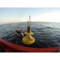
AXYS Metocean Buoy Supports Offshore Wind
farm development “FEW Baltic II”. The WatchKeeper buoy is equipped to provide wind speed and direction, air temperature, relative humidity, barometric pressure, solar radiation, directional waves, current speed and direction, conductivity, and water temperature in near real-time via satellite telemetry. The buoy also uses a new AIS Aid to Navigation device, which broadcasts buoy position and weather information to local vessel traffic. This both protects the buoy from collision by notifying vessels of its location, and can also act as an additional telemetry method providing data within

MTR100: MetOcean Data Systems
and trusted around the globe for over 40 years. The iBCN is the next-generation of MetOcean’s NOVATECH satellite beacons, designed for tracking and locating your assets up to full ocean depth (12,000m). The self-contained submersible beacons use the bi-directional capabilities of the Iridium satellite telemetry system, allowing the end user to receive real-time GPS location of their asset and also change and send various reporting parameters to the beacon. The MetOcean Iridium iSLDMB is an innovative, rugged, and compact A-size Self Locating Datum Marker Buoy. The iSLDMB was designed and tested to
Datawell Wave Buoy Supports NASA Beach Stability Study
provide an extended deployment life. At some locations the solar panels suffice and the batteries are not used at all. The buoy hull is composed of Cunifer-10, a copper/nickel/iron alloy that is a natural biocide and requires no anti-foulant coating. Full spectral data are transmitted via Iridium satellite telemetry every half hour. The buoy is purpose-built for wave observations and makes no concessions for additional sensors (such as a met tower), so the wave observations are of the highest quality and well suited for this research. The buoy was procured by Geodynamics (Newport, N.C.). It was deployed
Fastwave Offers Kongsberg Seagliders in Australia
is very excited to have Fastwave represent Seaglider in Australia. We have a mature and effective system that is poised to become an excellent tool for the maritime community, and we feel that Fastwave is the right partner to help us make that happen. Their years of experience in satellite telemetry, ocean data collection and environmental monitoring make them a perfect fit for our product and will allow them to provide excellent support to our Australian customer base.” fastwave.com.a


