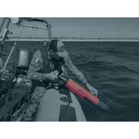
Summit at Sea Level to Accelerate Coastal Resilience in Louisiana
includes over 10,000 structures in Calcasieu, Cameron, Vermilion, St. Mary, Iberia, St. Martin, and St. Tammany Parishes.Investigate creating a designated national area of significance for wetland mitigation within Louisiana to optimize ecological returns.Identify regional projects that utilize sediment from the Mississippi River and Tributaries (MR&T) to construct resilient wetlands in Louisiana, designating them as eligible for mitigation credit to offset upstream impacts within the MR&T system.Reassess long-term mitigation strategies to ensure future environmental offsets are directly
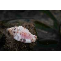
Deep Sea Mollusks Threatened by Mining Efforts
biodiversity, play a vital role in the food webs of deep-sea vents.According to the IUCN's latest "Red List" of threatened species, 62% of vent-dwelling mollusc species—125 out of 201—are now classified as at risk of extinction due to mining operations, which create sediment blankets that disrupt entire ecosystems."Deep-sea mining would smother the entire ecosystem," Dr Chong Chen, a member of the IUCN's Mollusc Specialist Group told Reuters, explaining that the loss of molluscs at a particular vent field would also mean the loss of all other non-mollusc
BluEnergies Confirms Offshore Liberia Exploration Remains on Schedule
.Seabed Geochemical Sampling is conducted through piston coring to collect evidence of migrated mature hydrocarbons (detection of fluorescent/natural oil compounds, hydrocarbon chromatography, thermogenic origin, etc.)Heat Flow Measurements are being performed to collect information about the relative sediment temperature and the thermal history of the undrilled Harper basin.This project completion is expected by Q4 2026, allowing for the integration of the data into a 3-D data re-interpretation of the numerous leads (basin floor fans) within the Blocks
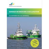
IADC Brings Dredging, Reclamation Seminar to Bali in November 2026
Dredging and Reclamation Seminar will take place November 23-26, 2026 in Bali, Indonesia. This four-day edition offers participants a opportunity to gain essential industry knowledge in an international setting.Dredging plays a critical and evolving role in today’s world. Beyond the movement of sediment, it contributes to coastal protection, global trade, energy transitions, and ecosystem management. As environmental and societal pressures continue to grow, there is an increasing need for professionals who understand both the technical and strategic aspects of dredging projects.The IADC seminar
SEABER MARVEL Micro-AUV Maps Beach for Littoral Reconnaissance
forces, special operations units, and mine countermeasure teams operating in contested littoral environments.The Limits of Existing Reconnaissance MethodsIn modern littoral warfare, precise knowledge of the seabed is essential before any amphibious landing. Channels, sandbars, obstacles, mines, and sediment structure all directly affect landing craft routes, timing, and survivability, yet existing reconnaissance methods each carry significant operational constraints.Combat divers offer high precision but are slow, cover limited areas, and face serious exposure risks in contested environments. Towed
Planting the Seeds of Inspiration: Eelgrass Restoration
local problem. It’s estimated that the world has lost approximately seven percent of its eelgrass.Restoring these eelgrass beds is critical because they provide habitat for many kinds of marine life, improve water quality by filtering out pollution, and the plant’s root system stabilizes the sediment on the seafloor and as a result protects shorelines from erosion.Eelgrass beds also play a significant role in mitigating climate change. The beds have a remarkable capacity to capture and retain carbon dioxide (CO2) from the atmosphere, the greenhouse gases that are responsible for global warming
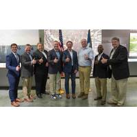
BRIN Taps Shipbuilder PIRIOU for Research Vessel Pair
will enable BRIN to conduct offshore scientific campaigns throughout Indonesian waters and the Natuna Sea (South China Sea). Designed for multidisciplinary missions, the vessel will enhance Indonesia’s capabilities in hydrography, physical and chemical oceanography, marine geology and geophysics, sediment sampling, physicochemical water characterization, scientific analysis, and the observation of marineecosystems and climate change impacts.SIGNING DAY: [L to R]: Ms. Inti Wikanestri, Deputy for Human Development, Society, and Culture, Ministry of National Development Planning (BAPPENAS); Mr. Amarulla
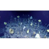
Plan for More Deep Seafloor Observations Might Find Something “Weird”
of around 2,442 meters in waters off the Johnston Atoll, roughly 750–825 nautical miles southwest of Honolulu, Hawaii.The dive log on the day of the discovery states:“The bottom was characterized by large boulders, cemented basalt, and rocks with a heavy manganese crust and light dusting of sediment. The dive track going upslope was on a sustained community of sponges that also included deep-sea octocorals and associated invertebrates. When Deep Discoverer reached a ridge, the current changed. Here, the community was composed almost exclusively of glass sponges and their diversity increased
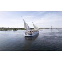
First Person: Exploring the Nile River
specialty. The Egyptian religion venerated a deity of flooding and fertility, Hapy. About fertility, the Nile’s modern name comes from Nelios, the Greek word for river valley. But the ancient Egyptians called it Aror Aur, meaning “black,” a reference to the dark nutrient-rich sediment, explains Barry J. Kemp in Ancient Egypt: Anatomy of a Civilization.The Nile even played an important role in the creation of the monumental tombs such as the Great Pyramids of Giza that reach four hundred feet or so in height. We know from ancient papyrus diaries that workers transported


