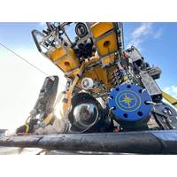
OET Testing New ROV Cameras for 3D Model Making
;1 centimeter) visual and acoustic data over the seafloor using a new widefield camera array system and Norbit wideband multibeam sonar. The widefield camera array was co-developed by the Ocean Exploration Trust and Sexton Corporation with funding from the Office of Naval Research (ONR). A customized software package for the Norbit sonar was recently developed by Corps of Exploration Navigator Dr. Kristopher Krasnosky, which takes raw data collected by sonar and allows onboard teams to visualize it in real-time.High-resolution visual and acoustic data collected by the ROV-mounted sensors will be used to
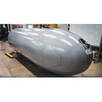
Nauticus Robotics Bags $2.7 Million Contract Extension from Leidos
platform, Aquanaut, this derivative robot features technology to support security activities and is advancing to complete longer and more challenging missions. In addition, this award allows further autonomous behavior and operational capability enhancements to toolKITT, Nauticus' proprietary software package developed to enable an ecosystem of autonomous actions for subsea vehicles and serves as the foundation for this work."I am very proud of our team's performance resulting in this follow on award, further cementing our partnership with Leidos," said Nicolaus Radford, founder and
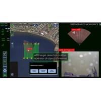
Greensea Launches OPENSEA Edge
and video perception feeds while providing autonomy, communications, and task management for the robot. This platform puts a tremendous amount of processing power at the edge, right on the robot, where it can work directly with sensor data and make decisions for the vehicle. OPENSEA’s Safe C2 software package for low bandwidth and high latency communications links provides a seafloor to over-the-horizon communications solution for operators supervising the robot. With the open architecture framework of OPENSEA and available processing space, developers can install their own autonomy and perception-handlin
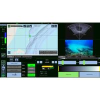
Greensea Announces Software Upgrades, VideoRay Partnership
Technician. Workspace and Professional Workspace have been upgraded to version 5.0.All standard software on VideoRay’s Mission Specialist Series ROVs was updated earlier this month.Founder and CEO of Greensea Systems Inc. Ben Kinnaman commented, “OPENSEA with Workspace is the standard software package on VideoRay’s Defender and Pro5 vehicles. OPENSEA provides the capability to perform advanced autonomous missions and prepares these vehicles for future technology advances as an open architecture platform. The newest versions of Workspace are the result of a direct collaboration with
FarSounder, Navtor Partner
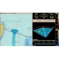
FarSounder and Navtor announces a new partnership, with FarSounder now including support for NAVTOR official ENC chart data in itsbase software package.Navtor is centered on creating e-Navigation tools that are safe, simple and efficient. Similarly, FarSounder’s Argos 3D Forward Looking Sonar is designed to provide safe navigation by detecting many ocean obstacles via an easy-to-understand user interface. According to the pair, this partnership will bring an impactful software update for Argos technology."By implementing the NavtorECDIS Kernel in the FarSounder platform, we bring official
Subsea Tech: Bathymetric Survey of Mediterranean, Dead Seas via Drone
methods.The bathymetric system consisted of a standard commercial DJI drone (UgCS SkyHub onboard computer and terrain following system with radar altimeter) and Echologger ECT400 single-beam echo sounder provided by SPH Engineering, Latvia. For data processing, the Eye4Software Hydromagic software package was employed.“I was surprised by the maneuverability of the system and how easy it is to conduct bathymetric surveys using a UAV equipped with an echo sounder. Some of our survey areas were 400-500m away from take-off/landing positions and that means that the term “remote sensing&rdquo
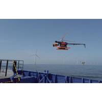
Buss Energy Acquires Stake in Drone Inspection Firm
advantageous in offshore use."Thus, even with increasing sizes of the wind turbines, no additional stop landing is needed. Furthermore, the drone inspection flight is fully autonomous and continuously monitored. The high-resolution image data is evaluated by using the in-house developed AERO-Software Package. Damage detection and classification is largely automated with the support of Artificial Intelligence (AI)," the owners say.The subsequent automation of data transfer to the customer's software environment and the automatically generated reports enable efficient and objective reporting
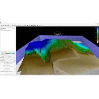
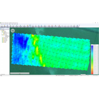
Using High Res 3D Meshes for improved Shape Reconstuction of Marine Survey Data
or structure, but by themselves pose challenges for visualization and quantitative analysis. To address these limitations and bridge the benefits of both point clouds and gridded surfaces, QPS has created tools for creating and working with high resolution 3D meshes, directly in the QPS Fledermaus software package. The new techniques can be used with the majority of common survey formats, with data coming from photogrammetry, LiDAR, or multibeam. The primary requirement is that the data is dense enough to support the 3D reconstruction process.Supporting Structure From MotionBefore adding functionality
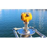
RS Aqua launches WaveRadar REX2
technique that has been used by the WaveRadar REX over the past 20 years. This new higher frequency sampling unit enables a greater measurement range of up to 80 m, and the same high accuracy over this distance (3 - 6 mm, dependent on range).Every WaveRadar REX2 will be supplied with a new software package called WaveConfigurator, enabling system set up and diagnostic monitoring by end users in the field. Unlike its predecessor, the WaveRadar REX2 incorporates an LCD screen for instantaneous sensor measurement display, as well as status and health data. It has a complete stainless-steel and Polytetrafl


