Scientists Complete 1700km Autonomous Acoustics Mission
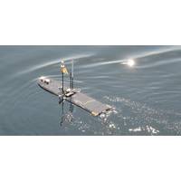
technique for mapping and counting schools of fish has been tested on an autonomous marine platform in the North Sea, offering a new method for collecting data on fish stocks.The U.K.’s Centre for Environment, Fisheries and Aquaculture Science (Cefas) and U.S. based Liquid Robotics, A Boeing Company, have deployed, tested and recovered a remotely piloted Wave Glider, which was adapted to allow scientists to collect high quality broadband fisheries acoustics data.As part of a multi-vehicle mission under the U.K. NERC/Defra funded AlterEco project, the Wave Glider called Lyra was deployed
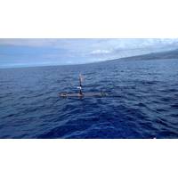
Wave Gliders to Study Arctic and Southern Oceans
questions has plenty of challenges and we needed a platform we could trust and adapt. The modularity allows us to deploy our own sensors and adapt autonomy algorithms so that the vehicle will optimally sample the ocean.”Working together with Liquid Robotics, a wholly owned subsidiary of The Boeing Company, these top oceanographers have conducted long duration scientific missions in the Arctic, Pacific, Southern and the North Atlantic oceans. Exploring the vast, remote regions of our ocean, especially in the Arctic and Antarctica, is incredibly challenging. Deploying Wave Gliders in the most
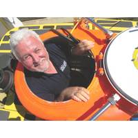
View from the Top: Dr. James Delgado, NOAA Director of Maritime Heritage
, I’ll also be travelling to San Francisco where we’ll be doing deep-sea exploration, including what will be the first time we’ll be able to lay eyes on, and do a detailed map of, the wreck of USS Independence aircraft carrier that we did an initial sonar mapping of last year with The Boeing Company. I’ve also recently been planning with the State of California’s State Parks team and others to better map and understand the maritime cultural landscape north of San Francisco. This area, known as “the Redwood Coast,” was part of California’s lumber industry
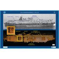
'Amazingly Intact' WWII-era Aircraft Carrier Surveyed
Marine Sanctuary and nearby waters. The carrier is one of an estimated 300 wrecks in the waters off San Francisco, and the deepest known shipwreck in the sanctuary. The mission was conducted last month using an 18.5-foot-long autonomous underwater vehicle (AUV), Echo Ranger, provided by The Boeing Company through a cooperative research and development agreement with NOAA's Office of Oceanic and Atmospheric Research. Boeing also partnered with technology company Coda Octopus to integrate its 3D-imaging sonar system, Echoscope, into the AUV. "Boeing is excited for the opportunity

NOAA Forms Panel to Guide Ocean Exploration
Nye vice president for communications and external relations, National Ocean Industries Association. Dominique Rissolo, Ph.D., executive director, Waitt Institute. Richard J. Rikoski Ph.D., CEO and chief scientist, Hadal, Inc. Lance M. Towers, director, advanced technology programs, the Boeing Company. Congress designated NOAA the coordinator of a national ocean exploration program, and mandated the creation of an Ocean Exploration Advisory Board under the Federal Advisory Committee Act. The board is expected to meet twice a year and will report directly to the NOAA administrator on matters
General Dynamics takes Rudy deLeon on Board
, deLeon served as a member of the professional staff and staff director for the U.S. House Armed Services Committee. DeLeon began his government career in 1975, holding various staff positions in the U.S. Senate and House of Representatives. After he left the federal service, deLeon worked for the Boeing Company for five years as a senior vice president, leading all U.S. federal, state and local government liaison operations. “Rudy brings a wealth of experience and his insights on defense policy make him a valuable addition to our board,” said Phebe N. Novakovic, chairman and chief executive
AXYS Hires Tarle as President & CEO
AXYS Technologies (AXYS) said it has welcomed a new President and CEO, Terry Tarle, to the AXYS team. Terry joins AXYS from his post at Aeroinfo Systems, a Boeing Company where he was Chief Operating Officer accountable for developing and managing new Boeing maintenance technologies marketed worldwide. Prior to Boeing, Terry was the national director of Telus Geometrics and a senior vice president with Sierra Systems as well as having founded a Victoria based high tech company which he led for 14 years. “This decision follows an extensive search for the right candidate who will not only