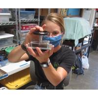
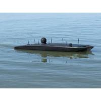
MTR100: Underwater Cameras, Lights and Ocean Landers
;J.W. Fishers (MA) MacArtney/LuxusOutland Technology (LA) Reach Robotics (AUS) (formerly Blueprint Labs) Remote Ocean Systems (CA)ROVSCO (TX) Sidus Solutions (CA)SubAqua Imaging (CA) SubC Imaging (NL) Teledyne Marine/Bowtech (DK) ConclusionsBuilding you own underwater imaging system provides insight to what manufacturers have faced, and what questions to ask sales reps. You can see the engineering behind a commercial design because you’ve done it. You can also spot mistakes. Cameras for ROVs, which are in and out of the water frequently, can get away with
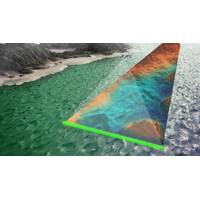
Lidar Helps to illuminate the Future of Oceans
our oceans remaining unexplored, despite technological advancements, due to crushing pressures, freezing temperatures, and pitch-black darkness. One tactic to overcoming these limitations, however, may use more than just lidar.Engineers at Stanford University have developed an aerial solution for underwater imaging by combining light and sound, each filling in the gaps created by the other. Electromagnetic radia-tion (such as visual light, microwave, and radar signals) loses energy when passing from the air to the water and vice versa; soundwaves struggle in a similar sense. The hybrid Photoacoustic Airborne
iXblue, ThayerMahan in Unmanned Surface Vessel Pact
ThayerMahan, a company specializing in autonomous maritime security solutions has partnered up with iXblue, a company specializing in navigation, acoustic positioning, and underwater imaging.The two companies are teaming up to provide unmanned maritime and survey services using iXblue’s DriX Unmanned Surface Vehicle (USV) in North America as well as internationally.In a statement on Monday, the companies said that ThayerMahan’s expertise in maritime domain awareness, and iXblue’s Unmanned Surface Vessel (USV), would help both companies address a wide range of maritime and survey
Sonardyne Acquires 2G Robotics
UK-based marine technology company Sonardyne International announced it has acquired Canadian underwater imaging and inspection specialist 2G Robotics.2G Robotics will join the Sonardyne group of companies, while remaining an independent business and brand, continuing to serve its customer base in unmanned and autonomous underwater vehicles (AUVs) and remotely operated vehicles (ROVs). 2G Robotics’ founder Jason Gillham will continue to lead the company as Chief Executive Officer.The acquisition of 2G Robotics is the latest step in Sonardyne’s long-term growth strategy and follows the
USVs Secure Offshore Oil and Gas Infrastructure
of bottom valves, vertical pipes, fittings, pipelines and other rig components can be part of scheduled, routine checks or be done on-demand to investigate something out of the ordinary discovered by rig watchstanders.Three primary missions the rig command center would utilize a USV for include:For underwater imaging, the 12-foot MANTAS could be equipped with Norbit iWBMS STX multi-beam sonar, a forward-looking or side-scan sonar, or any of many other commercial-off-the-shelf underwater sensors.For surface investigation, which would include area security, external rig structure investigation and surface
IUEM Chooses iXblue Equipment
Navigation, positioning and underwater imaging solutions provider iXblue said it has been chosen by the European Institute for Marine Studies (IUEM) to provide 8 Canopus long baseline (LBL) transponders for a geodetic mission off the coast of Sicily. Deployed on the seabed, 2,500 meters below the surface, the Canopus transponders will measure the crustal deformation along the North-South Alfeo faults with a millimeter-scale resolution over the course of four years.Hubert Pelletier, Head of iXblue Acoustic division, said, “Because the Canopus transponders precisely meet the exacting requirements
iXblue Equips Manned Submersible for Titanic Mission
OceanGate, Inc., a provider of manned submersible services, and iXblue, a global company that provides innovative solutions for navigation, positioning and underwater imaging, are combining forces to conduct the first manned submersible expedition to the wreck of the RMS Titanic since 2005.iXblue’s Phins 6000 inertial navigation system and Posidonia USBL positioning system will both be used for the accurate and reliable navigation and positioning of OceanGate’s Titan, the newest addition to the company’s fleet of deep sea manned submersibles and the first privately-owned manned

Shell Ocean Discovery XPRIZE Announcements at OI2018
is a series of linked, free-to-attend Technical Tracks which will enable participants to follow given themes in detail. These range from tracks devoted to Hydrography, Geophysics & Geotechnics, Unmanned Multi-Vehicles & Vessels and Oil & Gas to tracks given over to Marine Renewables, Underwater Imaging & Metrology and Navigation & Positioning. Conference Manager Ellen Burgess says: “With an overarching agenda to confront a range of technical, practical, environmental and fiscal marine science issues while trading insights and seeking solutions, the conference schedule draws
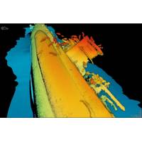
Expedition to Capture First 4K Images of the Titanic
A manned submersible set to survey the RMS Titanic wreck site this summer will be equipped with a range of high-tech underwater imaging equipment that will capture the first ever 4K images of the historic shipwreck. Starting in June 2018, manned submersible services provider OceanGate Inc. will lead a group of scientists, content experts and mission specialists to explore and survey the wreck site in a series of week-long missions from St. John’s, Newfoundland. For the mission, OceanGate's manned submersible Cyclops 2 will be equipped with cameras and lights from Canadian firm SubC Imaging


