Drones for Coastal Enviro Management
knowledge. Hiring experts in drone operations and data processing is typically necessary.• Best practices for using drones to collect geospatial data are well established. Guidance on best practices is available in publications such as the PrecisionHawk e-book Beyond the Edge, and the USGS Unmanned Aircraft Systems Data Management Plan 2015.• Workshop attendees identified short flight times due to battery constraints as one of the biggest limitations in drone technology at present. Other desired technological improvements include expanded payload capabilities, modularity to allow drones to carry

Aerial Drones Take Flight Offshore
; with an emphasis on quality, safety and risk management. Organizations that embrace these industry guidelines will augment their existing processes to improve data-gathering capabilities and safety with maximum cost efficiency and flawless execution. The Author Todd Chase is Unmanned Aircraft Systems Program Manager, Global Data Solutions, Oceaneering International. (As published in the October 2017 edition of Marine Technology Reporter
Thales Invests to Advance Autonomy
(MMCM) Program. Central to the growth of Thales’s future, Thales has also signed a five year agreement with West Wales Airport (WWA) which will continue to deliver the Watchkeeper programme to the British Army and to expand the innovative test, development and training of Unmanned Aircraft Systems (UAS). Thales has committed $8 million to the West Wales facility over the next two years, securing 40 jobs both locally and across the UK. \
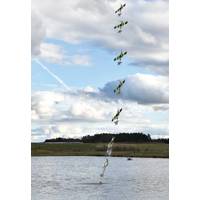
History Meets Technology in Shipwreck Alley
and rocky areas of Lake Huron that trapped these ships in the past are just as difficult to navigate today, and no single tool is a catch-all solution for finding and recording information about shipwrecks. This research project will test methods of surveying shallow, nearshore water with unmanned aircraft systems (UAS), and will explore deep, offshore waters using different acoustic surveying systems, looking for the best approach to rapidly collect information. The first phase of the project will run from April 10 through 21. Sanctuary partners NOAA Remote Sensing Division and Alpena Community
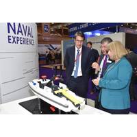
New Unmanned Vehicle for Maritime Warfare
Elbit Systems introduces Seagull, a new multi-mission unmanned surface vehicle system for maritime warfare missions Drawing on know-how derived from generations of unmanned aircraft systems (UAS) design, development and operation and its naval capabilities, Elbit Systems’ newest offering in the unmanned platform field is Seagull - an organic, modular, highly autonomous, multi-mission unmanned surface vehicle (USV) system. Seagull is a 12-meter USV with replaceable mission modules, with two vessels capable of being operated and controlled in concert using a single
U.S. Approves BP Drone Surveys of Alaskan Oilfields
BP has been authorized to use unmanned aircraft systems, or drones, to conduct aerial surveys of pipelines and other infrastructure on Alaska's North Slope, the first commercial drone flights over land, U.S. authorities said on Tuesday. AeroVironment started flying its Puma AE drone to survey BP's pipelines, roads and equipment at Prudhoe Bay, the largest U.S. oilfield, on Sunday, the Federal Aviation Administration said. (Reporting by Ros Krasny; Editing by Doina Chiacu)
There’s an App for That!
, homeland security, law enforcement and other users of unmanned systems can benefit, too. “We’ve standardized the means of controlling and communicating between the ground and the bird and all of the systems involved. The standard that we’re working on is called the Unmanned Aircraft Systems (UAS) Control Segment, or UCS, and it is hardware independent,” said Rich Ernst, who leads the USC architecture development in DoD.” All systems do not necessarily use the same functions, but with many systems you have to accept what functions the OEM provides.
USNS Swift Completes Aerostat and UAV Testing
Harris, as they could serve as future platforms to conduct counter illicit trafficking operations in the AOR. "In the current fiscal environment, U.S. 4th Fleet is exploring innovative, cost effective solutions that can address the capability gaps caused by budget cuts. Aerostats and unmanned aircraft systems are platforms that warrant more research due to the benefits of enhanced fuel efficiency, payload capacity, and persistence," Harris said. "By leveraging the unique capabilities each platform has to offer, we can bring low-cost, high-tech tools to maintain a robust detection and