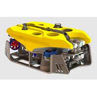
Forssea Unveils Hybrid ROV for USV Applications
for offshore wind O&M applications with ability to conduct faster surveys in the water column up to +2.5 knts current, according to Forssea Robotics.The ARGOS-X ROV will be equipped with Forssea full autonomy software suite and compatible with Starlink real-time remote supervision through any web browser.“Forssea Robotics has been collaborating with EXAIL since 2020 and we are proud to see the ARGOS-X ROV onboard the upcoming Drix O-16 recently announced during Oceanology show in London,” the company said.Exail Introduces New Transoceanic Uncrewed Surface VesselARGOS-X can be upgraded
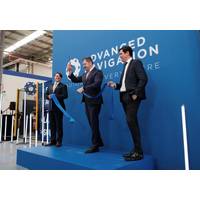
Advanced Navigation Unveils Hi-Tech Robotics Facility in Australia for AI-Powered Navigation Systems
; Nova-C lander as part of NASA’s ongoing Commercial Lunar Payload Services (CLPS) program.•Cloud Ground Control - A revolutionary cloud-based solution that allows pilots and mission planners to remotely command and control a swarm of uncrewed vehicles across air, land and sea through a web browser. By enabling real-time video feed, and telemetry, and easy access and management of captured data, Cloud Ground Control provides full remote visibility and situational awareness in search and rescue, emergency response and disaster relief operations.•Guiding visually impaired passengers -
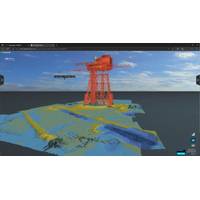
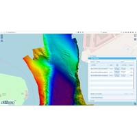
EIVA's Cloud-Based Thin Client Simplifies Sharing and Viewing of Project Data
Danish maritime and offshore energy industry survey software and equipment manufacturer EIVA has launched a cloud-based thin client, NaviSuite Cloud Viewer, enabling NaviSuite users to share project data with end clients in a web browser. "This provides powerful data visualization for operators and end clients – and eliminates the need to download any third-party programs.With this, operators can give their end clients the ability to easily navigate projects using high-performance data visualization capabilities, such as viewing DTMs, 3D models, and point clouds from any angle, observati
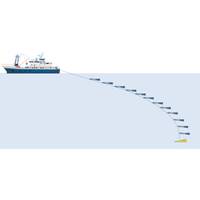
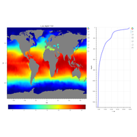
Towed Chain of Probes Helps to Investigate Ocean Eddies
of oceanographic and bio-geochemical properties of the seawater in up to 25 different water depths.The data are recorded at 10 Hz (every 100 ms) and stored in each probe. Once per second all probes transmit a data set to the deck unit. On board, the data can be loaded via WLAN on any device with a web browser and displayed in various graphics.In the ocean, it is common to record individual profiles. CTD-rosettes, gliders, AUVs or drifters, all record a one-dimensional profile. In contrast to this, our towed system allows several profiles to be taken at the same time. The temporal interpolation to display
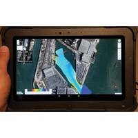
NORBIT DCT – Hydrographic Survey Made Easy
bathymetric data, ready to be post-processed and delivered to the end client.What is DCT?The Data Collection Tool (DCT) - is a survey data acquisition utility, part of NORBIT’s offerings aimed to simplify the standard bathymetry survey operations. The general bathymetry grid is dis-played in a web browser allowing quick estimation of the coverage and data quality in real-time while running the survey.DCT can be operated with a simple touch screen of the navigation plotter, tablet, smartphone or PC by a single person. By reducing the amount of configuration required by the user the real-estate on

New KONGSBERG Mapping Cloud Solution
data, which can be subsequently made available to use in diverse applications and products.Mapping Cloud enables existing PC applications to be run in a Virtual Machine (VM) environment, and allows users to efficiently manage data processing, archiving and sharing with partners and customers through web browsers. With Mapping Cloud, data uploaded in e.g., Australia could be processed in Paris and the results displayed in San Francisco on a user's favorite application. By sharing secure data that can be worked on simultaneously, colleagues in different locations can share the workload and potentially
Real-time Mapping, Visualization in CARIS Onboard 2.0
leaving an area. Focused around the latest web map technology, the redesigned control centre dynamically controls and monitors the automated system. Products generated including surfaces, backscatter mosaics, and the survey track lines are live-streamed during acquisition and accessed through a web browser. By providing access to processed products in a web application, the new Control Centre allows review of a survey dataset from any device with a network connection to the vessel. This increased access allows information about survey operations to be accessible when and where needed. Other

Aquabotix Introduces Remote Piloting Capabilities
Users of Aquabotix’s underwater vehicles and cameras now have the ability to pilot their devices remotely from any web browser-enabled device, from anywhere in the world, thanks to the newly introduced Live Remote Control from UUV Aquabotix Ltd. Live Remote Control enables users to operate Aquabotix’s Endura ROV (remotely operated vehicle), Hybrid AUV/ROV (autonomous underwater vehicle/remotely operated vehicle) and AquaLens Connect (networked underwater camera system) during underwater activities from any location globally, using browser-based devices such as computers, phones
Open-source Software for Environmental Science Community
RTS has engaged with the Defense Science and Technology Laboratory (Dstl) and Royal Navy staff to present the software capabilities and discuss uses. The web application software architecture separates data access and manipulation from data visualization, allowing devices running only a web browser to rapidly interact with data handled on a server or desktop PC over a network. Benefits of this approach include the potential for powerful data visualization and interaction on low-powered mobile devices. The U.K.-based company, which provides a wide range of sonar services to


