‘GliderPalooza’ Offers Glimpse of Underwater Weather
The U.S. IOOS-coordinated GliderPalooza sets the stage for oceanographers to collect critical ocean data from instruments attached to gliders.
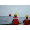
Gliders are autonomous underwater vehicles that contain a small battery pack and use changes in buoyancy to propel themselves vertically and horizontally through the water. Their relatively low cost compared to use of oceanographic vessels has resulted in a proliferation of their use as either a substitute for or addition to traditional oceanographic sampling strategies.
One of several coordinated glider deployments organized by U.S. Integrated Ocean Observing System (IOOS) Regional Associations, GliderPalooza is a series of glider deployments that focus on specific variables, such as water temperature, salinity, chlorophyll, dissolved oxygen and optical characteristics. Glider operators measure variables of interest from a variety of water depths within a targeted geographic area.
GliderPalooza 2015, funded by a number of government agencies and universities, brought together glider operators representing 18 institutions in the U.S. and Canada, leveraging their respective skills and individual program data-collection efforts to serve the larger glider community both in the U.S. and abroad.
GliderPalooza 2016 built upon the partnerships formed in 2015 and began in the spring. The first mission assessed the shelf stratification in the eastern Mid-Atlantic Regional Association Coastal Ocean Observing System (MARACOOS). Additional deployments will follow in the summer and fall and will zig-zag across the continental shelf from Massachusetts to New Jersey and south to the Chesapeake Bay region.
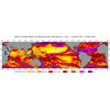
Among other objectives, the MARACOOS glider effort will be measuring the Mid-Atlantic Cold Pool, which is a mass of cold water trapped beneath the warmer surface waters in the summer. The Mid-Atlantic Bight Cold Pool, undetectable by satellite observation, has a large impact on the distribution of economically viable fisheries and affects the duration and intensity of hurricanes with the potential for landfall. Real-time data collected by these gliders will be harvested by the National Data Buoy Center and transmitted to the Global Telecommunications System (GTS), where data are made available for assimilation into local, regional and global ocean forecasting models. The data sets are also archived by the National Center for Environmental Information.
A major focus of the 2016 GliderPalooza effort is the application of Quality Assurance/Quality Control of Real-Time Oceanographic Data (QARTOD) algorithms to real-time glider data sets prior to being delivered to the U.S. IOOS Glider Data Assembly Center (DAC). These QA/QC tools are based on the recently published U.S. IOOS Manual for Quality Control of Temperature and Salinity Data Observations from Gliders, which provides guidance about specific QC procedures for data providers to follow while collecting data in real time. Adherence to these procedures ensures that the data submitted to the Glider DAC receive uniform quality control. “It was rewarding to work with the enthusiastic glider community during the development of this manual,” said Mark Bushnell, the lead editor of the manual.