3D Image Fusion for Ultra High Resolution Seabed Surveys


-

-
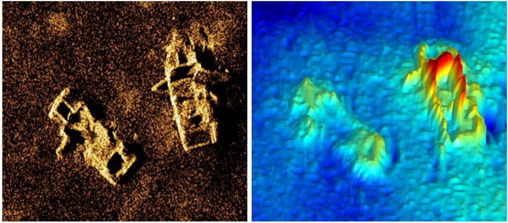
 Figure 2: Note the correlation between the image and bathymetric features. The blurring behind the target is a by-product of the lack of acoustic data in the shadow region.
Seafloor mapping is one of the oldest professions known to humankind. Mariners have been measuring the depths under their vessels for thousands of years. The science of measuring and charting the depths to determine the topography of the seafloor is known as bathymetry. Bathymetry is gathered from a variety of sources, including satellites, aircraft, surface ships, submersibles and underwater platforms. Bathymetric data are used to generate navigational charts, 3D models, seafloor profiles and other fusion images. Today, governments, navies, telecom companies, offshore energy corporations and scientific institutions map the seafloor for many applications. Knowledge about the seafloor is imperative to better understand our oceans.
Our perception of the ocean floor has expanded through the use of 3D geospatial applications. However, most 3D bathymetry maps that historically represent continuous global seafloor coverage are artist renditions. It wasn’t until recently that concerted efforts have been made to compile sonar bathymetric data in the public and classified domains to produce higher-resolution 3D digital terrain models of the seafloor Given that seabed surveys are often conducted in areas for which little a-priori information is available, the real-time generation of 3D seabed maps will significantly improve our ability to explore and understand the seafloor environment.
While conventional sonars are commonly used for seafloor imaging and bathymetry, they suffer from some basic limitations. Firstly, the imaging resolution, or the system’s ability to distinguish closely spaced objects, is not constant but degrades with range. In Synthetic Aperture Sonar (SAS), these limitations are overcome by using the sonar platform’s trajectory. The forward motion of the sonar is used to synthesise an array that is much longer than its physical length by combining multiple pings in software rather than adding more hardware as a way to gain higher resolutions.
SAS uses sophisticated signal processing techniques to compare the multiple observations of the same area of seafloor to calculate its depth. The image resolution of the seabed is significantly increased – often by an order of magnitude - compared to conventional sidescan sonar. In essence, the resolution becomes independent of range and of frequency. SAS systems can achieve an image and bathymetry resolution of a few centimeters even in very deep waters.
Figure 1 shows a simultaneously co-registered INSAS reflectivity image and 3D bathymetry of discarded automobiles in Halifax, Nova Scotia collected during sea trials with the Defence Research Development Canada.
While SAS has been around for over a decade, military applications such as naval mine countermeasures have been its major development driver. However, SAS is a multi-use technology with great potential for offshore oil and gas surveying, hydrographic surveys, underwater archaeology, benthic habitat mapping and deep sea mining. The viability of SAS as a high resolution survey sensor seems a logical progression for the industry with the additional benefits of increased data quality, better resolution and a pathway to a deliverable of more integrated data fusion surveys.
In addition to reflectivity images, SAS can produce highly detailed topographic maps of the seafloor by detecting the angle of arrival of seabed echoes coming from a given range bin. In a configuration known as Interferometric SAS (INSAS), two vertically separated arrays produce bathymetric maps that are exactly co-registered with the corresponding SAS images. This combination of synthetic aperture processing and interferometry solves the problems of limited resolution and coverage rates encountered with conventional swath bathymetric sonars and multibeam echo sounders. When the InSAS bathymetric resolution approaches that of the corresponding SAS image, it becomes possible to overlay the reflectivity and topography to create a true 3D picture of objects on the seabed.
The use of INSAS systems – such as the AquaPix system produced by Kraken Sonar Inc. - is a promising tool for achieving these objectives in both very shallow water and deep water environments. AquaPix® produces real-time, high resolution, three dimensional (3D) digital terrain models of the seafloor with bathymetric resolution as low as 5cm x 5cm and simultaneous co-registered imagery resolution as low as 3cm x 3cm.
With high resolution INSAS it is possible to use image fusion techniques to combine the bathymetric data with the reflectivity data to create a true 3D representation of objects on the seabed. The ability to generate centimetre-scale resolution in all three dimensions has the potential to provide significant improvements in the detection, classification and identification of small seabed objects.
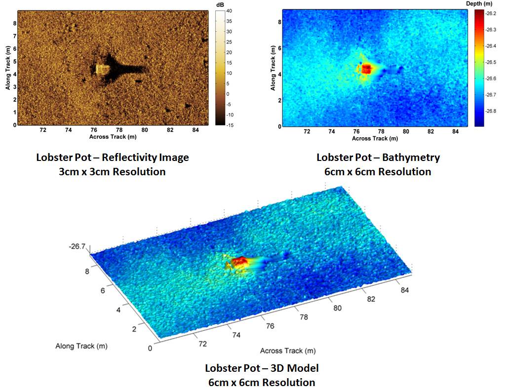
Figure 2 shows an example of a co-registered INSAS reflectivity imagery and corresponding bathymetry image from a sea trial conducted with the US Naval Undersea Warfare Center, Rhode Island.
The image clearly shows a target of interest at 76 m range across track. When merged with the 3D bathymetry, the dimensions of this target are quickly determined, enabling single-pass detection, classification and identification of the target of interest; it is an abandoned lobster pot.
Image Fusion is a process of combining the relevant information from a set of images of the same scene, into a single image, wherein the resultant fused image will be more informative and complete than any of the input images. One of the goals of image fusion is to create a single enhanced image more suitable for the purpose of human visual perception, object detection and target recognition.
The reliability and overall detail of the image is increased, because of the additional information. Image fusion has become a common term used within medical diagnostics and treatment. The term is used when multiple images of a patient are registered and overlaid or merged to provide additional information. The utilization of Interferometric Synthetic Aperture Sonar to generate high resolution 3D digital terrain models and maps of the seabed is an ideal application of pixel level image fusion.
Seabed survey workloads can significantly increase with the number of images that need simultaneous monitoring. A human observer cannot reliably combine visual information by viewing multiple images separately. Further, the integration of information across multiple human observers is often unreliable. Thus, a seabed survey system that can provide a series of single fused images with more accurate and reliable information than any source image is of great practical value.
The potential advantages of image fusion using Interferometric Synthetic Aperture Sonar are that information can be obtained more accurately, as well as in less time and at a lower cost. These advantages correspond to the pursuit of complementary, more timely and less costly information.
Complementary information from co-registered, high resolution imagery and bathymetry data enables potential new features in the underwater environment to be perceived that perhaps are impossible to perceive using just an individual data source. Multiple sensors providing redundant information can also serve to increase reliability in the case of sensor error or failure.
Timely information results when an INSAS system is employed, since the overall system may enable a human operator to reach a conclusion about some property of the environment more rapidly than making decisions based upon data from individual sensors operating at different resolutions and acoustic frequencies.
Less costly information may be obtained from a system using multi-image fusion. For example, a single sensor can be used to obtain performance that could only otherwise be achieved using a combination of expensive multiple sensors.
Multi-sensor image fusion seeks to combine information from different images to obtain more inferences than can be derived from a single image. It is widely recognized as a very efficient tool for improving overall performance in image based applications. When used with Interferometric Synthetic Aperture Sonar it enables ultra high resolution seabed mapping operations to be carried out in a more timely and cost-effective manner.
(As published in the APRIL 2015 edition of Marine Technology Reporter - http://www.marinetechnologynews.com/Magazine)