Polarcus Expands Broadband Project Off Australia
Polarcus has secured further industry prefunding enabling its multi-client survey project offshore Australia to expand northwards with an additional 7,130 square kilometers.
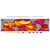
Consequently the Capreolus 3D Project, which was announced in October 2014, will now comprise approximately 22,130 sq. km overall, providing exploration companies with basin-wide broadband 3D seismic dataset across the Roebuck Basin, offshore North West Shelf, Polarcus said.
Seismic acquisition on the original program commenced early January 2015 with two Polarcus A-Class 3D seismic vessels utilizing the company's RightBAND technique for broadband data acquisition. The expanded survey is now estimated at approximately twelve vessel months duration overall, and will utilize an additional Polarcus 3D seismic vessel for part of the program. As of date, seismic acquisition is approximately 40% complete (of the new expanded program).
The resultant data from the Capreolus 3D Project will be processed through a pre-stack depth migration routine by DownUnder GeoSolutions in Perth, Australia, with final data products expected to be delivered within Q1 2016.