The Quest for the Moho


-
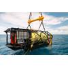
 Image: Woods Hole Oceanographic Institution
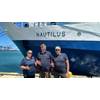
-
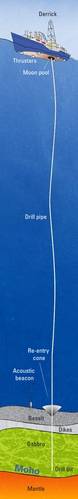 Image: Woods Hole Oceanographic Institution


Between Earth's crust and mantle lies a mysterious boundary
Prologue: A Valiant Quest
For much of his half-century career, Henry J. B. Dick has been on a quest to reach a mysterious line several miles beneath the seafloor with a curious name: the Moho.
The Moho is widely believed to be the boundary between Earth’s crust and an underlying layer of denser rocks in Earth’s interior called the mantle. It is named after Croatian seismologist Andrija Mohorovic, who first detected it in 1909 by examining seismic waves moving through the Earth.
Ever since, earth scientists have yearned to find out what really happens at the Moho. An ambitious effort to drill to the Moho called Project Mohole was launched in the early 1960s—in the same hopeful era when the United States launched its space program. Scientists used a barge with a drilling derrick to bore a shallow test hole into the ocean crust, but the engineering challenge was far more expensive than anticipated, and the project abruptly ended when Congress cut off funding.
We’ve put astronauts on the moon, but we still have yet to reach the Moho. So to this day, we still don’t fully understand the fundamental processes that go on within our planet to create Earth’s crust.
“We’ve done a great job of planetary exploration on the moon and on Mars, but we’ve not been so good at funding planetary exploration on Earth,” said Dick, a geologist at Woods Hole Oceanographic Institution (WHOI). “I suspect we spend more on NASA’s budget in a year than for our total exploration of the three-fifths of our planet beneath the oceans. It’s really kind of mind-blowing.”
In 1976, the scientific community tried to use a drilling ship to bore through the crust but didn’t get more than 1,600 feet before the holes collapsed. Drilling through the brittle lava rocks of the upper crust proved too challenging, and the idea was abandoned.
But Dick, a young graduate student on that first effort, refused to give up. He devised a new strategy to drill on Atlantis Bank, a curious sunken island in the undersea mountains in the Indian Ocean. There, he believed, lower crust and mantle rocks lay closer to the surface, leaving less rock to drill through to reach the Moho.
He has led drilling efforts to Atlantis Bank in 1987, 1997, and 2016, and sometime in the next three years or so, he hopes the drillship will return to complete the job—and that he will be aboard when humankind first reaches the Moho.
One: Boundary Controversies
The tale of the Moho really begins in 1909, when Mohorovic detected differences in sound waves reverberating off a horizontal line in the Earth —“just the way an echo reflects off the wall of a canyon,” Dick said. The line would come to be known as the Mohorovic discontinuity, or Moho, and it delineated a difference in physical properties within Earth’s interior. The waves accelerated through rocks below the discontinuity, indicating that the material there was made of denser minerals. Scientists deemed the discontinuity to be the boundary between Earth’s crust and mantle. It lay 20 to 35 miles beneath continents, but only 2.5 to 6 miles below ocean crust.
More than three decades later, Harry Hess, a Princeton geologist who enlisted as a naval officer during World War II, entered the story. As his ship crisscrossed the Pacific transporting troops, he turned on an echo-sounder that continually imaged the seafloor. It revealed undersea mountains, mid-ocean ridges, and deep trenches.
These were among the first clues that led to Hess' speculative theory in 1962 that material from the mantle flows upward to fill the void where Earth’s great tectonic plates are pulled apart and solidifies to form mid-ocean ridges on the seafloor. The theory explained how the seafloor spreads apart, expanding oceans and moving continents, until it sinks again in ocean trenches.
But what exactly happens at the Moho? Over the years, scientists analyzed seismic waves used to probe into the seafloor, or they examined segments of seafloor, called ophiolites, that had been thrust up onto land by tectonic forces. They saw evidence that ocean crust has a structure resembling a three-layer cake. Right above the Moho, magma cools and crystallizes into a layer of rocks called gabbro. Above that is a layer of hardened vertical sheets of surging molten rocks called dikes. The icing on top is composed of rapidly cooled lava that erupts onto the seafloor as pillow basalts.
“The general framework,” Dick said, “is that you have a magma chamber above the mantle, which crystallizes the coarse rocks called gabbro that make up the lower crust. Above that, the chamber roof cracks open, and sheets of magma shoot up out of the magma chamber. They break through the surface, and lava spills onto the seafloor and cools and solidifies into basalt.”
Hess, however, had another possible theory: The Moho, he said, could be the result of water released from the rising hot mantle as it cooled near the surface. According to the theory, the water reacts with rocks in the mantle known as peridotite, chemically altering them to form a thick layer of a less dense mineral called serpentine. Hess called the Moho an “alteration front”—a boundary where mantle rock was altered to become serpentines. The theory was dismissed at first, but new evidence suggests that Hess may have been right—at least beneath certain types of mid-ocean ridges. Scientists now believe, however, that the water is not released from the mantle; instead, seawater percolates down through cracks in the mantle to react with peridotite.
“So there’s a lot of controversy over what the Moho actually is,” Dick said.
Two: The First Crusade
The best way to gain knowledge of the fundamental process of crustal formation, of course, would be to look at the Moho directly. In 1957, Hess was talking with a colleague, Walter Munk of Scripps Institution of Oceanography, who idly suggested enlisting a team of scientists to drill a hole to the Moho through the seafloor, since Earth’s crust is much thinner under the oceans than it is beneath continents. The pair would propose the idea to the American Miscellaneous Society, a group of scientists that entertained, as its name suggests, out-of-the-box ideas.
The idea garnered support in the scientific community. But more important, it gained political support as a way to seed new deep-ocean-drilling technology that the Soviets seemed to be trying to develop, too. Thus Project Mohole was launched—alongside the contemporaneous race to the moon.
In 1961, near the island of Guadalupe off the west coast of Mexico, a rig on a barge drilled in 11,673 feet of ocean, through 558 feet of sediments lying atop the seafloor, and into 43 feet of basalt rock at the top of the ocean crust.
But this initial victory was quickly followed by frustrating and expensive technological challenges. Keeping a ship in the ocean in one position was hard. Fractured rocks fell into holes, often sealing them and forcing the scientists to start anew. Drill bits broke and pipes bent, and valuable equipment was lost in the deep. As cost estimates to continue the project mounted to $64 million and then $122 million, Congress abruptly killed funds for Project Mohole in 1966, and the scientific crusade to reach the Moho seemed irretrievably dead.
Three: Geologic Knights
Henry Dick was an undergraduate geology student when Project Mohole ended. In 1972, as a graduate student at Yale, he was invited to attend a prominent conference on ophiolites, those sections of ancient crust and mantle that have been exposed above sea level. At the time, ophiolites offered a way to investigate how ocean crust forms, Dick said—but they were fossilized and extracted out of their original contexts, and, as such, provided limited value for revealing whatever dynamic processes are going on at the Moho.
At the conference, Robert Coleman, a prominent geologist, told Dick and an impressionable group of graduate students about the nascent Ocean Drilling Program (ODP). Though it had failed, Project Mohole had established ocean drilling as a viable and valuable scientific pursuit. The project successfully developed a lot of technology, including a way to drill through water; a system of thrusters and acoustic signals that could keep a ship stationed above a hole; and re-entry cones that allowed scientists to keep replacing worn drill bits and reinserting them into the same hole.
ODP incorporated these technologies in a new drillship for the scientific community that could revitalize an attempt to drill to the Moho, Coleman said. “We could do this, but some of you in this room will have to dedicate your careers to it,” Dick recalled Coleman saying. Dick took up the gauntlet.
The new drillship’s mission focused on drilling and recovering just sediments lying atop the ocean crust, rather than the crust itself. But on an expedition in 1976, scientists quietly tried and failed to use the ship to drill through the crust. They didn’t get more than 1,600 feet into it before the holes collapsed, and the idea was abandoned again. But Dick, who was on that expedition as a young graduate student, remained undeterred.
Four: A Seafloor Siege
It took more than a decade after the ophiolite conference for Dick to build a strategy for pursuing the Moho. He and Jim Natland at Scripps Institution of Oceanography proposed to take advantage of “tectonic windows” in the ocean crust to get to the Moho faster—“simply go someplace where Mother Earth had done a lot of the work for us by tectonically stripping off the shallow layers,” he said.
In 1986, they surveyed a potential target in the Indian Ocean: Atlantis Bank, a place where a huge segment of deep ocean crust had slid upward on the ramp of a tectonic fault, beyond the lavas and dikes of the upper crust. It moved up so high, in fact, that
at one point in geologic time, it broke above the sea surface and formed an island before subsiding under the sea again. At Atlantis Bank, the fractured rubbly debris created by faulting had been eroded away, exposing a surface of coarse lower-crust gabbro, which proved easy to drill.
“I got a cruise approved—just barely—by the Ocean Drilling Program,” Dick said, and in 1987 he returned aboard the ODP drillship, JOIDES Resolution, to take his first stab at penetrating the Moho.
Aboard the 469-foot Resolution looms a derrick almost 20 stories above the sea surface. It sits above a hole in the center of the ship called the “moon pool” through which an interconnected string of 30-foot-long metal pipes, attached one at a time, can be dangled through nearly four miles of water.
At the end of the string are a four mace-like circular drill bits with a circular space in the middle. The bits rotate to pound down and around a thin cylinder of rock, forming rock cores 10 feet long by a few inches wide. As the drill goes down, the core samples are pushed up into the space between the bits. A device called a core catcher pulls the rock samples back up the pipe string to the ship, so scientists can analyze them.
“The rocks can be tough to drill because they are often fine-grained and hard and filled with cracks, so they fracture easily,” Dick said. “Pieces break loose and jam the bits. Cores break off. The bit jams in the hole because pieces fall between the wall, the hole, and the drill pipe, and all of a sudden you’ve locked it in place. As often as not, you dynamite off the drill string, because you’re nailed to the seafloor.
“Drilling into the Earth is an astounding combination of extremely high technology and pure black magic,” he said. “You’re always wondering what’s going on at the bottom of that hole, and you can’t always figure it out.”
Five: A Jumbled Tapestry
Dick and company were having a difficult time figuring things out on their 1987 expedition. They drilled several unsuccessful holes and were taking heat from scientists on shore who were keeping track of the proceedings. With time for the expedition running out, Dick scrutinized sonar maps of the seafloor and spotted a hopeful target.
“We lowered a TV camera down, and the whole seafloor was bare rock,” Dick said. “We lowered down the drill string and spun it into massive gabbro and drilled 500 meters in two weeks—the most successful hard-rock hole ever drilled. The rocks we recovered were spectacular, because they were completely unlike what people thought the lower crust would look like, and a huge contrast to what people saw in the Pacific.”
Ocean crust in the Pacific does appear to have the neat three-layer-cake structure: gabbro, dikes, and basalt. But Indian Ocean crust looks like a cake that a throng of partygoers grabbed and shredded into a mishmash.
“This radically changed our perception of how the lower crust forms in the mid-ocean ridges,” Dick said, referring to the undersea mountains at the edges of Earth’s tectonic plates, where magma rises from the mantle to create new seafloor.
In the Pacific, Dick explained, a steady stream of buoyant hot magma continually rises, transitioning through a series of chemical and physical changes to make crust resembling layer cake. Then the newly formed ocean crust spreads out laterally on either side of mid-ocean ridges.
In the Indian Ocean, however, magma rises and crust forms in a far more dynamic arena. As the plates move apart, large blocks of crust are sliding up, down, and against one another on massive faults, smashing, cutting, and intruding into one another to create even more fractures. Magma is squeezed through these fractures, filling in the spaces, zigzagging and crystallizing and adding more disorder to the jumbled crustal tapestry.
Six: A Scientific Holy Grail
The findings also presented the first clues of another fundamental discovery that Dick and colleagues pursued: The reason ocean crust was different at different mid-ocean ridges is that the ridges spread apart at different rates. Ridges in the Pacific are fast-spreading; Indian Ocean ridges spread very slowly.
Dick and colleagues went on to find yet another type: ultraslow-spreading ridges, where large areas of the seafloor have no crust at all. “That’s one of the great surprises of the last ten years of scientific exploration in the oceans,” he said. “The crust has always been regarded as a continuous covering over the mantle. That’s really a huge change in how we think about our planet’s evolution—the crust does not completely cover the Earth.”
But those crustless areas are rare. “We still want to understand how crust forms in the 90 percent of the ocean that does have crust,” Dick said. “We know what the composition of the top part of the crust is, but we don’t know what’s right above, at, and beneath the Moho. We want to understand what’s happening to magma as it progresses through that interface between overlying crust and underlying mantle.”
Mantle rock that has been uplifted and exposed to seawater and reduced pressure is chemically altered. The holy grail for scientists is to get their hands on a sample of unadulterated mantle rock right from the source.
Seven: Battles Lost
A decade would pass before Dick could revive the quest to the Mohole with an expedition in 1997 to Atlantis Bank aboard the JOIDES Resolution. The cruise began auspiciously. Drilling proceeded nearly a mile into the seafloor. Then disaster struck.
“We were 1,508 meters deep,” he said. “We were on our way to the crust-mantle boundary with two weeks still left to go in the expedition. We would have gotten down to around two kilometers”—about three-quarters of the way to the Moho.
“We’re in a storm and we’re working, and the ship rose up, and the pipe bumped into a ledge,” Dick recalled. “It snapped off at a weak point near the top of the hole. Two hundred thousand pounds of metal plunged five hundred meters and smashed into the bottom of the hole, and corkscrewed up the hole, jamming it permanently. And that was the end of that hole.
“I’ve woken up in the middle of the night repeatedly to the ‘thunk, thunk’ of the ship as all that pipe dropped off.”
He wouldn’t get another chance to return for 19 years.
Eight: The Next Crusade
“I wrote proposal after proposal arguing to return for another attempt,” Dick said. But there’s only one JOIDES Resolution and numerous scientists around the world who request to use it.
Finally, he got approval for the SloMo Project to drill to Moho at the slow-spreading Southwest Indian Ridge in two phases. In December 2015, Dick, at age 69, returned to Atlantis Bank aboard the Resolution, serving as co-chief scientist with Chris MacLeod from Cardiff University in the first leg of a new attempt to drill a hole to the Moho. Once again, difficulties arose. Three of the four heads of the drill bit broke off right at the start. Then the ship had to cease operations for several days and steam toward shore to evacuate a technician who needed medical attention.
The expedition drilled to a depth of 809.4 meters, about 2,665 feet or a half-mile, beneath the seafloor. It was about half as far as they had hoped, but they came away with hopeful signs. They recovered a solid 10-foot piece of gabbro from beneath the ocean floor.
“It’s the longest single unfractured piece of rock ever drilled in the ocean crust,” Dick said. It signals that they passed a point where seawater percolates down to chemically alter the rock, so it is more pristine. It is also less fractured, which should make drilling easier when they return for leg two of the drilling program, which has been approved by the Science Evaluation Panel of the International Ocean Drilling Program, and is in early planning stages.
“The planning committee for this operation is serious about going back soon,” Dick said. “We just hope that they understand that ‘soon’ is a five-year, not a twenty-year, time frame.”
Nine: Jousting Theories
“There’s a whole list of reasons why geologists are fascinated by the Moho and how ocean crust forms,” Dick said. “The Moho may not be the crust-mantle boundary—or at least not at slow-spreading ridges. It could be an alteration front as Hess said”—the limit of where seawater percolates down, reacts with peridotite in the mantle, and changes it into a less dense rock called hydrated serpentinite.
Those chemical reactions have a lot of implications. First, they cause carbon dissolved in seawater to precipitate as calcium carbonate rock, or limestone.
“All those buildings on Wall Street that have green marble with white streaks through it are made of hydrated serpentinites,” Dick said. “The white is carbonate veins.”
The process can pull huge amounts of carbon out of the ocean and sequester it in rock. That allows the ocean to absorb more carbon dioxide, a greenhouse gas, out of the atmosphere—a planetary process that regulates global warming.
The reactions also cause valuable minerals such as copper, silver, gold, and zinc to leach out of rocks. They concentrate the minerals into hot, buoyant hydrothermal fluids that rise in hot springs on the seafoor, where they cool, solidify, and are deposited in massive mounds of metal sulfide minerals. Sections of such mineral-rich seafloor crust have been uplifted onto land by tectonic forces and have been mined for thousands of years; now industry is starting to explore mining them on the seafloor.
The reactions also produce hydrogen gas, which combines with carbonates in seawater to form methane—food for many microbes. “So there may be a whole new planetary biosphere beneath the Earth’s crust,” Dick said.
A final reason to analyze mantle rock might is that they may hold clues to the raw materials from which out planet, and life on it, originated.
Epilogue
“My undergraduate advisor at the University of Pennsylvania, Reg Shagam, was a student of Harry Hess’,” Dick said. “Hess’ enthusiasm and excitement were uniquely transmitted to every student of his that I have ever met. He imbued them with remarkable passion for the Earth, and in turn they passed this on to their own students, and I am one of them."
Dick, a scientific grandson of Hess, made these remarks in 2011 when he was awarded the Harry H. Hess Medal by the American Geophysical Union for “outstanding achievements in research on the constitution and evolution of Earth and other planets.”
“Scientists are fundamentally explorers. That’s what drives them,” Dick said. “Some people collect pre-Colombian art, some people collect bottle caps. Scientists collect knowledge.
“You can watch the WHOI scientific staff, and they get to be 65, and a certain contingent just disappears,” Dick said. “Then there’s a few you’ll notice that have to be carried feet first out of their office. Because they are scientists. That’s what they are, and they can’t conceive of being anything else.
“I will officially retire in a year, but I’m not going to leave my office,” he said. “They’re going to carry me out of my office when I’m cold and stiff, and they’ll wrench my rock hammer out of my cold, stiff fingers.”
But not before that next cruise to Atlantis Bank, Dick hopes, with the Moho within his grasp.
(Source: Woods Hole Oceanographic Institution's Oceanus Magazine)
(Source: Woods Hole Oceanographic Institution's Oceanus Magazine)