TCarta Wins NOAA Grant to Enhance Satellite Derived BathymetryTech

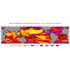
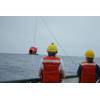
32,000 miles of Alaskan coastline pose a challenge and an opportunity for Satellite Derived Bathymetry. Technologies developed to survey water clarity in daily satellite imagery (upper right inset) can be used as a tool to determine precise collection of high-resolution imagery for Satellite Derived Bathymetry surveying (lower right inset). Image courtesy TCarta
TCarta Marine won a Small Business Innovation Research (SBIR) Phase II grant from the National Oceanic and Atmospheric Administration (NOAA), focused on enhancing Satellite Derived Bathymetry technology for application in the coastal waters of Alaska.
Satellite Derived Bathymetry (SDB) extracts water depth measurements from multispectral satellite imagery using advanced physics-based algorithms. Traditionally, this technology has yielded the most accurate results in clear, calm waters; however, TCarta has recently taken the lead in expanding SDB applications to more challenging marine environments worldwide.
“With the NOAA SBIR grant, our objective is to explore what SDB can achieve in Alaska’s coastal waters with the expectation of applying our findings to the greater Arctic region,” said TCarta President Kyle Goodrich. “This research will benefit hydrographic surveying, coastal zone management, infrastructure development, and other coastal marine projects at high latitudes.”
Begun in 2020, the NOAA SBIR Phase I research expanded the potential sources of satellite imagery for the Alaskan coast. Winter darkness, floating sea ice, turbulent spring runoff, plankton blooms, and unpredictable tidal variations make it difficult to capture images with the quality necessary for SDB processing. Just a small window of acquisition time exists during the summer, and it varies for different areas along Alaska’s 32,000 miles of coastline.
“By analyzing data captured with several types of satellite sensors, including multispectral, hyperspectral, green laser, and synthetic aperture radar, we are determining which images and methodologies – or combinations – produce the optimal characteristics for SDB,” said Goodrich. “This is helping us devise a tasking strategy to capture Alaska imagery at the right time with the right sensors.”
An important Phase I result was the development of automated tools to assess water clarity in daily satellite images to monitor water clarity for suitable conditions for SDB image tasking or planning airborne LiDAR surveying, Goodrich added.
In Phase II of the NOAA program, TCarta has shifted focus to SDB data processing and hydrographic analysis by developing new ways to improve confidence in the seafloor depth measurements derived from Alaskan imagery. The Colorado firm is creating workflows involving Artificial Intelligence to identify and minimize errors in SDB measurements, predict uncertainty and to integrate established hydrographic standards, thereby enhancing interoperability of SDB with other technologies.
“By the start of summer 2022 collection season, we will have developed a multi-satellite coastal surveying capability and a collection strategy for maximization of these technologies in Alaskan and Arctic waters,” said Goodrich.