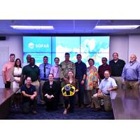
US Navy Taps Into Sofar Ocean's Data Buoy Network for Weather Forecasting
Smart Mooring marine sensing devices; the development of the Bristlemouth open ocean connectivity standard; its approach to ensemble-based data assimilation and coupled modeling; and its DaaS products. Representatives from Naval Oceanography’s subordinate commands and partners — the Naval Oceanographic Office (NAVOCEANO), the Fleet Numerical Meteorology and Oceanography Center (FNMOC), and the Naval Research Laboratory (NRL) — also attended the event. The groups provided critical insights about hardware deployment capabilities, data needs, and the Verification and Validation (V&
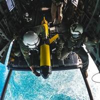
Teledyne Slocum Glider Deployed from US Navy Helicopter
is a long-endurance AUV used for multiple persistent operational missions, including oceanographic data collection. Teledyne has delivered over 1,000 Slocum gliders to a global customer base. The Slocum glider is the backbone of the US Navy LBS-G program, with over 210 delivered since 2009. The Naval Oceanographic Office (NAVOCEANO) pilots the LBS gliders and includes collected data supporting Navy operations. Until this successful helicopter deployment, LBS gliders were almost exclusively launched and recovered by the T-AGS 60 class multi-mission ocean survey ships
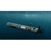
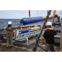
HII Debuts REMUS 620 Unmanned Underwater Vehicle (UUV)
, robotic platforms.REMUS 620 is the same size and weight of the first and only full-rate production medium UUVs: the MK 18 Mod 2, Littoral Battleship Sensing-Autonomous Undersea Vehicle (LBS-AUV) and LBS-Razorback systems operated by the U.S. Navy’s Mine Countermeasure Squadrons, U.S. Naval Oceanographic Office and Submarine Forces, respectively.Multiple REMUS 620s operating collaboratively can be deployed from submarines, small manned or unmanned boats, amphibious ships, surface combatants and helicopters. REMUS 620 can also be used as a platform to launch and operate other unmanned vehicles
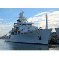
Halter Marine Awarded Contract for T-AGS 67
, the first of which, USNS Pathfinder (T-AGS-60), entered service in 1994. Today, six of the ships are still operational, including the newest ship, USNS Maury (T-AGS-66), commissioned in 2016.Owned by the U.S. Navy, Pathfinder-class vessels are operated by Military Sealift Command (MSC) for the Naval Oceanographic Office (NAVOCEANO). They have mostly civilian crews, including scientists from NAVOCEANO.Work for T-AGS 67 will be performed in Pascagoula (76%); Harahan, La. (8%); Belle Chase, La. (4.5%); Alpharetta, Ga. (4.5%); Mathews, La. (2.3%); Axis, Ala. (2%); Houston (1.5%); and Sherwood, Ore. (1
Subsea Defense: Navy Deepens Commitment to Underwater Vehicles
Temperature and salinity affect water density, which directly impacts a submarine’s buoyancy, or how sound travels underwater, or how storms form and intensify.Today, a third of those gliders are deployed operationally around the world at any given time, controlled by pilots at the Naval Oceanographic Office (NAVO) Glider Operations Center located at Stennis Space Center, Mississippi. The pilots communicate with the glider with Iridium satellite links to collect oceanographic data such as water temperature, salinity, water clarity and depth, and provide positioning and course instructions.Gliders
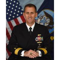
INTERVIEW: RDML John Okon, Commander, Naval Meteorology and Oceanography Command
Research, developed many of the unmanned systems currently in use throughout the Fleet. Additionally, Naval Oceanography fielded SLOCUM gliders in 2010, and by 2019 was the first organization to successfully deploy and operate over 100 unmanned systems simultaneously from one location, the Naval Oceanographic Office’s Glider Operations Center.Please discuss in overview the size and shape of unmanned maritime systems currently in the ‘fleet’ or at the disposal or USN, and discuss how you see this expanding and evolving in the future.In the past 10 years, unmanned systems capabilities
MIND Tech, Klein Complete Naval Exercise
MIND) and its Klein Marine Systems subsidiary completed a live Advanced Naval Technology Exercise (ANTX) in a collaborative effort with the Naval Surface Warfare Center Panama City Division (NSWC PCD); Commander, Naval Meteorology and Oceanography Command (CNMOC) and in coordination with the Naval Oceanographic Office's Fleet Survey Team (FST), at NSWC PCD.Klein and a group from NSWC Panama City partnered to integrate the Klein UUV 600 and µMAX technologies into its Iver3 vehicle. In addition, Klein partnered with Seafloor Systems, Inc. to integrate the Klein MAX View 600 gap-filling
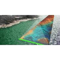
New Tech Aids US Navy Mapping
; hydrographic mapping capabilities being incorporated by Areté back into the original PILLS system for the US Navy is extremely gratifying.”Areté first demonstrated the upgraded PILLS during an Advanced Navy Technology Exercise (ANTX) with the Hydrographic Department at the Naval Oceanographic Office (NAVOCEANO) in August. The exercises involved mapping areas of the Eastern Gulf Coast and providing in-depth analysis and post-processing training for Department of Defense personnel at the Joint Airborne Lidar Bathymetry Technical Center of Expertise, with participation from NAVOCEANO
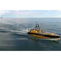
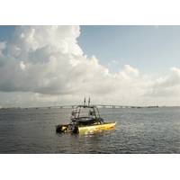
ASV Global to Supply USV to University of Southern Mississippi
addition to support USM’s growing capabilities in Unmanned Marine Systems Certification and our research toward improved mapping and charting in the Hydrographic Science Research Center.” USM’s sponsors including NOAA’s Office of Coast Survey and the US Naval Oceanographic Office will also benefit substantially from this state-of-the-art USV investment. “We are excited that USM has this cutting-edge platform available to teach the next generation of hydrographers” said Rear Admiral Shepard Smith, Director of NOAA’s Office of Coast


