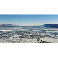
To Predict Future Sea Level Rise, We Need Accurate Maps of the World’s Most Remote Fjords
themselves and what is causing them to retreat or even disappear. The large glaciers that meet the ocean in Greenland and Antarctica balance their mass over time largely in pace with the climate. When it snows or rains they accumulate ice, and they lose ice to melting and calving – the process where chunks of ice break off and eventually melt away into the sea.But over the past few decades they are losing mass at an accelerated pace, with more icebergs calving into the ocean and more ice being melted from below by relatively warm seawater.Estimating how much mass will be lost is often highlighted
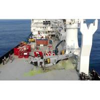
US Navy Recovers Downed Helicopter from Record Ocean Depth
remotely operated underwater vehicle (ROV) with the ability to meet deep ocean salvage requirements to a maximum depth of 20,000 feet.CURV 21 is a 6,400 pound ROV designed to meet the U.S. Navy's deep ocean salvage requirements down to a maximum depth of 20,000 feet of seawater. CURV was deployed in March 2021 to the North Pacific to recovery a Navy CH-60S which was lost in January 2020 from the USS Blue Ridge (LCC-19). CURV successfully rigged and recovered the aircraft from 19,075 feet, a new SUPSALV Record. (Photo: U.S. Navy)The SUPSALV team met the contracted salvage vessel in Guam, completed mobilizatio
Unmanned Vessel Launched to Survey Western Galveston Bay
An unmanned vessel is now surveying more than 3,500 nautical miles of the Western Galveston Bay, near the Houston Ship Channel.DEA Marine Services, a division of David Evans and Associates, Inc. (DEA), in Vancouver, Wash., equipped its survey boat Sigsbee with a Sea Machines Robotics SM300 autonomous-command and remote-helm control system to fulfill a National Oceanic and Atmospheric Administration (NOAA) contract.Sigsbee, which is serving as an autonomous daughter craft for the project, is effectively doubling coverage by operating without an onboard crew, while collaboratively following another
ASL Hires Taillefer
products for operational purposes and fleet uses —often in high tempo naval and military operations. Taillefer has extensive operational experience in applying his expertise and knowledge in the oceanographic tactical domain. He spearheaded operational oceanography, acoustic modeling and decisional technologies with DND, General Dynamics (GD) Canada and Fisheries and Oceans Canada (DFO) since the early 1990s. At GD Canada, his work spanned from coordination and installation of sonar systems aboard Swedish warships at two Swedish shipyards (Karlskrona and Muskö Naval Base), worked on the

NOAA Names Werner Director of Scientific Programs
NOAA announced the appointment of Cisco Werner, Ph.D. as the new Director of Scientific Programs and Chief Science Advisor. As Director, Dr. Werner will continue the work of planning, developing and managing a multidisciplinary scientific enterprise of basic and applied research on the living marine resources. He assumed his new role on June 12, 2017. Prior to being named Director of Scientific Programs and Chief Science Advisor, he served as the Director of NOAA Fisheries’ Southwest Fisheries Science Center (SWFSC). Cisco brings extensive experience leading scientific
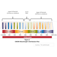
CWDM for the Subsea Market
Originally developed for the Metro Telecom market, CWDM (Coarse Wavelength Division Multiplexing) technology has become ubiquitous in all telecom markets as well as the subsea market. CWDM is a cost-effective and technology-efficient way to multiplex a number of signals on one fiber. There are a number of wavelength multiplexing techniques that can be utilized, depending on the number of wavelengths. Standard WDM (Wavelength Division Multiplexing) utilizes either two, three or in some instances four wavelengths using standard lasers. CWDM technology can multiplex up to 18 individual wavelengths
Cameras Chosen for Canada's Arctic Patrol Ships
has over 70 employees in Dartmouth, Vancouver and St. Johns, 190 employees in the U.K. and approximately 4,600 total across the world. “Further to our recent CCTV supply for the Halifax-class frigates IPMS upgrade we are able to leverage from our proven marine & naval camera technologies to support L-3 MAPPS, Irving Shipbuilding and RCN on the prestigious AOPS Program which is a key milestone in the renewal of Canada’s combatant fleet,” said David Fleming, Camera Systems Manager for Kongsberg Maritime. Forming a key part of the Integrated Platform Management
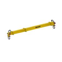
Modulift Spreader Beams Meet Revised DNV Standard
Press release - Modulift, a manufacturer of spreader beams, lifting beams and other below-the-hook equipment, has timed the launch of its subsea modular spreader beams to follow publication of a revised offshore standard from DNV GL AS—titled DNV-OS-H206—that references the use of spreader bars. DNV, formerly known as Det Norske Veritas AS, a global provider of knowledge for managing risk, has updated the standard that covers loadout, transport and installation of subsea objects. This was a new document in a series replacing the DNV Rules for Planning and Execution of
Northern Sea Route Usable 125 Days by 2050: New Report
The recently released Inter-governmental Panel on Climate Change (IPCC) report – ' Climate Change 2014: Impacts, Adaptation, and Vulnerability' – finds that the effects of climate change are already occurring on all continents and across the oceans. It also underlines that the prediction of ice-free periods in the Arctic Ocean is generally underestimated. Relevant maritime-focused excerpts from the report follow: Shipping from major European ports to Shanghai is some 40 percent shorter via the Northern Sea Route compared with the Suez Canal. Shorter shipping distance cuts emissions