Global Hydrographic Innovation and Technology Laboratory Established in Singapore
a start, the Joint IHO-Singapore Innovation and Technology Laboratory will embark on the following two pilot projects:Investigate the automated conversion of the IHO S-57 Electronic Navigation Chart (ENC) to the IHO S-101 ENC. This project supports the development of the Dual-Fuel Electronic Chart Display and Information System.Develop a digital Infrastructure to improve information exchange between harbours and hydrographic office. The outcome of this project will inform the IHO S-131 Marine Harbour Infrastructure product specifications.The Laboratory is overseen by a Governing Board chaired by Abri
AIS Data: History & Future
land-based AIS receivers. Governments are now using AIS in an innovative manner by creating virtual aids-to-navigation that provide an AIS signal to mark hazards to navigation in locations where a physical aid-to-navigation does not exist. The virtual aid appears on the electronic chart display and information system (ECDIS) of ships within range and they know (or should know) to avoid the location. By combining AIS data with other information, such as photos from surveillance aircraft or satellites, correlations can be made between individual vessels and pollution incidents.

Real-time ECDIS Updates via FleetBroadband
A contract signed in London at the end of last month by Inmarsat and SRH Marine SAIT formalizes arrangements for real-time Electronic Chart Display and Information System (ECDIS) updating to be accomplished ‘ship-to-shore’ using an application over FleetBroadband for the first time.The SRH Delta platform, which includes chart updates, publications and notices of mariners, will be available for L-band transmission to any FleetBroadband user equipped with the new, dedicated bandwidth Application Access Point Name (APN) developed by Inmarsat.“The SRH platform is the first application by
OSI Maritime Systems’ ECPINS Earns MED Type Approval
OSI Maritime Systems has received Marine Equipment Directive (MED) Type Approval certification from DNV GL for ECPINS Submarine (ECPINS) against new International Hydrographic Organization (IHO) and International Electrotechnical Commission (IEC) standards for Electronic Chart Display and Information System (ECDIS). The new IHO standards include new editions of IHO S-52 and S-64 which cover chart content, display aspects, and testing of data respectively. In addition, ECPINS also meets the new ECDIS performance standard set out by IEC 61174. &ldquo
Sonardyne Demonstrates Vessel Navigation Capabilities
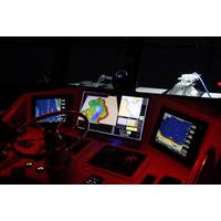
superyacht industry, commercial shipping and naval community attended the event in late November to witness first-hand the capabilities of NOAS as an important new aid to vessel navigation and underwater obstacle avoidance. Above the water, innovations such as ECDIS (Electronic Chart Display and Information System) which integrates GPS, AIS and radar, have delivered valuable improvements in situational awareness for captains and their crews. However, when navigating poorly charted or unfamiliar areas, commercial ships, expedition cruise ships and naval vessels remain vulnerable to groundings
Cyber-Attacks New Threats for Maritime Sector
is not good enough. We need to go above and beyond them to give robust training.” The collision of the cargo ship Rickmers Dubai with an unmanned crane barge in 2014 is an example of the perils of overreliance on e-navigation. Training standards around systems such as Electronic Chart Display and Information System (ECDIS) are mixed. “Officers need robust training in order to avoid misinterpretation of ECDIS and operating mistakes that could lead to expensive disasters. Beyond that manual navigation aids and skills are still crucial,” said Khanna.
ClassNK Issues Another Approval for ECDIS Training
ClassNK issued its Type Specific Training Course approval for “FURUNO MODEL FEA ECDIS & FURUNO MODEL FMD ECDIS” (Electronic Chart Display and Information System) Training Courses offered by Fleet Management Training Institute (Nerul, India), a group company of Fleet Ship Management Pvt. Ltd. The approval certifies that the course offered by FMTI complies with the leading classification society’s Standards for Maritime Education & Training under “ClassNK Prime Management Services for Education and Training”. Mr. Minoru Ohno from ClassNK Certification

GPS Spoofing and the Potential Perils to Ships at Sea
under development by the Chinese and the Indians. None of them are able to totally avoid vulnerability to spoofing because they all utilize relatively low power transmissions from orbiting satellites. GPS is now fully integrated into electronic navigation charting and the Electronic Chart Display and Information System (ECDIS), as well as other shipboard systems. In what I consider to be a short-sighted move, the United States shut down its Loran network several years ago, just as that technology was transitioning to the more sophisticated and less manpower-intensive electronic Loran (eLoran)