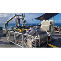
Kraken Wins Seabed Survey Contract in Australia
Kraken Robotics Inc. will supply high-resolution seabed mapping sonar service to Precision Hydrographic Services (PHS), a customer supporting the Australian Department of Defence. The Australian Department of Defence has awarded PHS a program to collect Hydrographic High Resolution Route Surveys (RS) for a number of Australian ports. The purpose of the RS is to enable the collection of Maritime Geospatial Information (MGI) to support maritime domain awareness through the acquisition of high-resolution seabed foundation data and associated oceanographic data.Under the scope of Kraken’s

Marc van der Donck Receives 2022 Alexander Dalrymple Award
Commission.Elsewhere, Capt Marc has led the Worldwide ENC Database Working Group through its transition from S57 Electronic Navigational Charts to WEND100 – the framework for globally consistent and high-quality nautical and hydrographic S-100 products. He has also contributed to Hydrographic Services and Standards Committee, Assembly and Council meetings
NOAA Seeks Applicants for Hydrographic Services Advisory Panel Membership
NOAA announced it is seeking candidates for the Hydrographic Services Review Panel, a federal advisory committee that advises the NOAA administrator on the agency's hydrographic programs, products and technology. Applications must be received by April 28.Quality data is essential to NOAA maritime programs, whether it is developing innovative products for precision navigation, creating richer data streams for ocean observations, or tapping into new possibilities of crowdsourcing and other modes of data collection. As future priorities are determined, we depend on advice from actual users of our
NOAA Taps Woolpert for Chesapeake Bay Watershed Study
surveying and collect bathymetric data for hydrodynamic modeling in the Chesapeake Bay Watershed. The $5.5 million award with a $1.4 million option, funded in part by the bipartisan Infrastructure Investment and Jobs Act, is being administered through NOAA’s Office of Coast Survey hydrographic services contract.This project will focus on 615 square nautical miles and include portions of the Potomac, Rappahannock, James, and York rivers, which in some areas have not been surveyed for more than 50 years. Woolpert will mobilize five hydrographic survey vessels, or nearly a quarter of its fleet
TCarta Opens Canadian Affiliate Office
marine geospatial researcher and consultant in Canada.Simultaneously, TCarta Canada announced its first contract – a pilot project to update bathymetric navigation charts for Baffin Island’s Cape Hooper and Kangok Fjord with SDB technology. The contract is administered by the Canadian Hydrographic Services, which has previously purchased SDB maps from TCarta.The partnership between TCarta Marine and Knudby is an ideal merger of complementary technologies. Knudby, who will serve as Managing Partner for the new office, has pioneered development of SDB algorithms for Canada’s coastal waters
NOAA HSRP Public Meet Webinar set for September 1-2, 2021
NOAA Hydrographic Services Review Panel (HSRP) Federal Advisory CommitteeWhen: Sept 1, 2021, 12:45-5:30pm EST; Sept 2, 2021, 1-5:30pm EST (Time/speakers are subject to change)Register: https://register.gotowebinar.com/register/5627376790601178124The meeting will focus on issues related to hydrographic and navigation services, observations and positioning including topics affecting the NOS’ Office of Coast Survey, Center for Operational Oceanographic Products and Services, National Geodetic Survey, and the University of New Hampshire’s and NOAA’s Joint Hydrographic Center
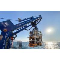
Rovco to Invest $13M in 'Rovco Survey Solutions', New Hydrographic Unit
Rovco launched a new hydrographic services division, “Rovco Survey Solutions”, offering a range of hydrographic, geophysical and site survey services across the offshore sector. In addition, Rovco are pledging an investment of more than $13 million in the new division over the next 24 months. Rovco continues to expand its survey team, which has already flexed to more than 45 people for recent key projects, by welcoming an additional 8 new survey staff members this month.“The launch of ‘Rovco Survey Solutions’ represents an important and significant milestone for our
Survey: UK Subsea Industry Shows Signs of Optimism
.”Rovco is one Subsea UK member which has capitalised on the rapid growth in offshore wind and believes the survey reflects the relatively buoyant mood in the industry as a result of diversification into this market. The Bristol-based global provider of remotely operated vehicle and hydrographic services, has reported more than trebling its revenues in the last 12 months.Rovco Chief executive, Brian Allen, said: “Having initially started out in oil and gas, almost 90% of our business now comes from the offshore wind sector. As a result of winning significant work in the renewable energy
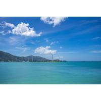
Rovco Tapped for Subsea Services at Beatrice Wind Farm
Rovco, a UK-based provider of ROV and hydrographic services, has signed a contract to carry out work on offshore wind farm Beatrice, the Scottish largest operational offshore wind farm. Rovco, which did not share the value of the contract, said it would carry out a campaign of inspection and survey work across nominated subsea jacket locations on the wind farm, including Export and Inter-Array cables to assist in informing the current condition and any potential maintenance planning at the site. The project will use the DPII vessel, Glomar Wave to deploy a WROV solution for asset and cable


