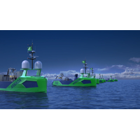
Sonardyne's Sensors for Ocean Infinity's Armada USV Fleet
vehicles (USV).Sonardyne said Wednesday it would provide the first wave of Ocean Infinity’s new Armada fleet with key sensor technologies for underwater platform navigation, tracking, control, and communications, as well as ensuring uninterrupted surface navigation, even when global navigation satellite system (GNSS) services are degraded or denied.The low-emission robotic fleet will initially see 17 bespoke designed uncrewed vessels added to Ocean Infinity’s existing robotics fleet.Ocean Infinity Launches ArmadaThe vessels will be able to perform offshore data acquisition and intervention
NovAtel Unveils Oceanix Nearshore Service
NovAtel, a OEM supplier of high precision Global Navigation Satellite System (GNSS) positioning technology, has unveiled its Oceanix Nearshore correction service at Ocean Business in Southampton, UK. Oceanix Nearshore, a subscription-based GNSS correction service for Precise Point Positioning (PPP), provides sub-decimetre positioning for marine applications such as dredging, hydrographic survey, mapping and coastal patrolling. The robustness of Oceanix infrastructure sets it apart from the competition. Oceanix precise corrections data is generated utilizing a network of over 80 strategicall
Fugro Awarded US Government Survey Work
provide integrated data collection and processing in support of the USACE’S National Coastal Mapping Program. Other services within the scope of this IDIQ contract include photogrammetry, vessel based hydrographic surveying, topographic and boundary surveying, conventional and Global Navigation Satellite System (GNSS) surveying, terrestrial and mobile LiDAR scanning and geographic information system (GIS) development and production
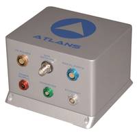
iXBlue and Septentrio Create ATLANS-C
of navigation, positioning, and mapping solutions, today launched its new ATLANS-C position and orientation system, developed in close cooperation with Septentrio Satellite Navigation. The system is designed to provide continuous and accurate positioning in urban environments, where global navigation satellite system (GNSS) signals are obscured, intermittent, or possibly distorted by reflective surfaces. ATLANS-C benefits from the optimized integration of iXBlue’s leading fiber-optic gyroscope (FOG) based inertial navigation system (INS) and Septentrio’s world-renowned multi-constellation
Compact Bathymetry Sonar: NORBIT Choose NovAtel® SPAN®
into the new NORBIT iWBMS Compact Bathymetry Sonar. They say that this combination of technologies produces integrated bathymetry solutions that are easy to operate and deliver previously unattainable miniaturization of the form factor. NovAtel’s SPAN technology brings together Global Navigation Satellite System (GNSS) positioning technology and Inertial Navigation Systems (INS). When coupled with the STIM300, a Micro Electromechanical Systems (MEMS) Inertial Measurement Unit (IMU) from Sensonor, it provides precision navigation for weight and sized constrained environments. It replaces previously


