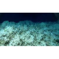
World's Largest Known Deep-sea Coral Reef Habitat Found
coral ecosystem right on the doorstep of the U.S. East Coast is a perfect example of what we can accomplish when we pool resources and focus on exploring the approximately 50% of U.S. marine waters that are still unmapped," said Derek Sowers, Ph.D., Mapping Operations Manager for the Ocean Exploration Trust and lead author of the study. "Approximately 75% of the global ocean is still unmapped in any kind of detail, but many organizations are working to change that. This study provides a methodology aimed at interpreting mapping data over large ocean regions for insights into seafloor
OET Testing New ROV Cameras for 3D Model Making
On October 22, the Ocean Exploration Trust (OET) launched a 14-day expedition aboard exploration vessel Nautilus to survey some of the most complex deep-sea geology around the Main Hawaiian Islands. The main purpose of the expedition is to test a new widefield camera array mounted on remotely operated vehicles (ROV). Footage from this system will then be used to create near real-time exciting applications for marine research and outreach. High-resolution video and sonar data collected on this mission will be used to construct three-dimensional models of each site using emerging tools developed by the
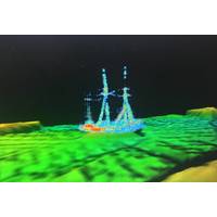
Discovery: Historic Shipwreck Found in Lake Huron
Researchers from NOAA, the state of Michigan, and Ocean Exploration Trust discovered an intact shipwreck resting hundreds of feet below the surface of Lake Huron. Located within NOAA's Thunder Bay National Marine Sanctuary, the shipwreck has been identified as the sailing ship Ironton. Well preserved by the cold freshwater of the Great Lakes for over a century, the 191-ft. Ironton rests upright with its three masts still standing."Using this cutting-edge technology, we have not only located a pristine shipwreck lost for over a century, we are also learning more about one of our nation's
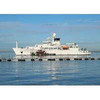
US Navy to Name Oceanographic Survey Ship USNS Robert Ballard
President John F Kennedy's PT-109. Ballard retired from U.S. Naval Service in 1995. In 1989, he founded the distance learning program the JASON Project, which reached 12 million school children; and the Institute for Exploration in Mystic, Conn, and is also the founder and president of the Ocean Exploration Trust. VIDEO: Up Close and Personal with Ocean Explorer Robert Ballar
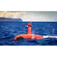
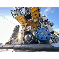
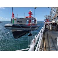
DriX USV Delivered to UNH CCOM
efficiency of the OECI’s ocean exploration operations. Delivered in July to UNH CCOM, DriX and its novel Universal Deployment System have completed sea acceptance trials and extensive personnel training during the summer of 2021 as well as integration and a first shakedown cruise onboard Ocean Exploration Trust’s E/V Nautilus in March 2022.“We are delighted to embark on this exciting endeavor, working collaboratively with our partners to develop and enhance autonomous technologies that will expand the limits of our capabilities and bring new efficiencies to our efforts to explore and
Seminar: NOAA Ocean Exploration Cooperative Institute - Exploring the US’s Blue Frontier
Please join us Aug. 11th at 3 p.m. EDT for a one-hour seminar on the Ocean Exploration Cooperative Institute (OECI), with Director Adam Soule and Manager Aurora Elmore. Opening remarks will be provided by NOAA acting Chief Scientist Craig McLean, Ocean Exploration Trust President Bob Ballard and NOAA Ocean Exploration acting Director Genene Fisher. This is the first in a six-part series and we invite you to attend and engage with presenters in live Q&A. Visit oeci.org/events/nsss to participate and see the full schedule.Background: The Ocean Exploration Cooperative Institute (OECI) is a NOAA-funded
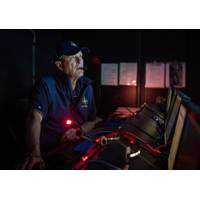
VIDEO: Up Close and Personal with Ocean Explorer Robert Ballard
under his command.At the age of 78, Robert D. Ballard is and always will be a scientist, an ocean explorer intrigued by finding clues to the unknown. Currently engaged in a $100m program with NOAA's Office of Ocean Exploration to map and characterize the US EEZ, a project which teams his ocean exploration trust with Woods Hole, the University of Rhode Island, the University of New Hampshire and the University of Southern Mississippi, Ballard has not been on the sea for nearly two years due to COVID.But Ballard – the author of multiple books, papers and articles, the subject of TV and film
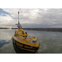
DriX USV Scores Contract with OECI
Cooperative Institute is funded by NOAA’s Office of Ocean Exploration and Research and is hosted at the University of Rhode Island in partnership with the University of New Hampshire, the University of Southern Mississippi, the Woods Hole Oceanographic Institution, and the not-for-profit Ocean Exploration Trust. This new five-year alliance is envisaged to extend NOAA’s reach and capabilities for its ocean exploration portfolio
Searching for Shipwrecks
by NOAA Great Lakes Environmental Research Lab, supported BEN and also conducted mapping and surveying in adjacent areas of the lake. Sponsored by NOAA’s Office of National Marine Sanctuaries, this project marks the first partnership between Thunder Bay National Marine Sanctuary and Ocean Exploration Trust."Working with Ocean Exploration Trust is an incredible opportunity for the public to discover Thunder Bay National Marine Sanctuary,” explains Jeff Gray, sanctuary superintendent. “Not only does Ocean Exploration Trust bring scientists from around the world to conduct cutting-edg