New AUV Helps Document Critical Minerals
a mission led by the Ocean Exploration Cooperative Institute (OECI), based at the University of Rhode Island’s Graduate School of Oceanography, with support from the National Oceanic and Atmospheric Administration (NOAA), the Bureau of Ocean Energy Management (BOEM), and the U.S. Geological Survey (USGS).As part of a larger expedition to expand knowledge of the seafloor, the OECI partnered with Orpheus Ocean to field-test their new AUV east of the Mariana Trench. The AUV successfully completed several dives to depths exceeding 5,600 meters (3.5 miles), including imaging polymetallic nodules on the
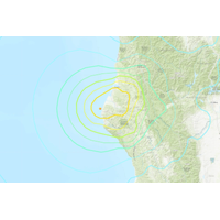
Satellite data from Ship Captures Landslide-Generated Tsunami
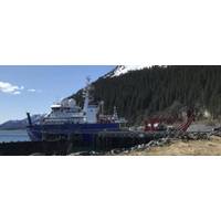
, the ship’s science operations manager and co-author of the study.Adam Manaster, then a graduate student working in Sheehan’s geophysics research group at CIRES and CU Boulder, took the lead on the project. The research team also included scientists from the United States Geological Survey (USGS) and the University of Alaska Fairbanks.The team used data from the ship’s external GNSS receiver and open-source software to calculate changes in the vertical position of the R/V Sikuliaq down to the centimeter level. They created a time series showing the ship’s height before, during
Sonardyne Holds Seabed Deformation Technical Workshop
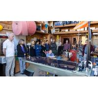
Deformation Technical Workshop bringing together some key members of the Sonardyne academic user community in the USA and Canada to share insights, experiences and how its GNSS-A and AZA instruments can be further improved to meet future needs.These included; Ocean Networks Canada, U.S. Geological Survey (USGS), Georgia Institute of Technology, Woods Hole Oceanographic Institution and the University of Washington, as well as our hosts Scripps Institution of Oceanography in California. As well as providing the stunning backdrop for this event, Scripps Institution of Oceanography furnished instruments for
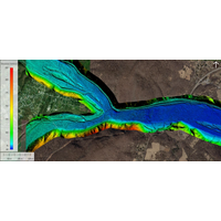
USGS : New Topobathymetric Dataset for Potomac River
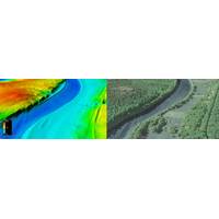
Teledyne Geospatial said the U.S. Geological Survey (USGS) and Dewberry, a privately held professional services firm, published a new topobathymetric lidar dataset for the Potomac River. The Potomac River flows from the Potomac Highlands in West Virginia to the Chesapeake Bay in Maryland. The lidar survey was conducted for USGS’s 3D Elevation Program (3DEP), with stakeholders including the USGS Earth Resources Observation and Science Center (EROS), National Geospatial Program (NGP), and Eastern Ecological Science Center (EESC) programs, as well as the Interstate Commission on the Potomac
New USGS National Map Data Reveals the Potomac River’s Submerged Topography
riverine topography. The maps were produced in two phases for more than 120 river miles of the Potomac River through a data-acquisition contract with Dewberry. The study area began near Hancock, Md., and extended downstream to the Little Falls dam near Washington, D.C.The project was co-funded by the USGS and the Interstate Commission on the Potomac River Basin (ICPRB). The publication of topobathymetric lidar for inland rivers was made possible in part by Inflation Reduction Act investments, which are advancing the 3D National Topography Model 3DEP initiative to better map and integrate the
Earthquake Offshore California Knocks Out Power for Thousands
A strong 6.4-magnitude earthquake struck off the coast of northern California on Tuesday, the U.S. Geological Survey said, leaving thousands without power.The earthquake, which struck at 2:34 a.m. (1034 GMT), was about 10 miles (16.1 km) deep, USGS said, and struck about 7.4 (12 km) west-southwest of Ferndale, California, a Humboldt County town about a four-hour drive north of San Francisco.Local media and others on social media reported there were numerous gas leaks, powerlines down, and at least one structure fire in Ferndale. A representative from the Humboldt Sheriff's Office was not
New Under-ice Observing Capabilities Could Lead to New Discoveries in the Great Lakes
navigates through these enclosed tunnels, this impressive underwater robot will soon be navigating its way under Great Lakes ice cover.NOAA GLERL’s partners on this project include Hibbard Inshore, the Cooperative Institute for Great Lakes Research (CIGLR), and the United States Geological Survey (USGS). (Photo: NOAA
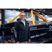
CTO in Focus: “Stop, Listen & Think” - One-on-One with Shepard Smith, XOcean
inspire people with it.He had set up some really visionary ways of integrating the ocean mapping program at NOAA, not only across NOAA so that the work we are doing for safety and navigation could also work for habitat and in fisheries, but also outside of NOAA so that we could do joint projects with the USGS and [others], to be able to learn from each other and do joint projects and really take this vision to reality of getting this done. Rick, himself, had so many mentees. I’m honored to claim that for myself as well.I understand that you recently took some time to hike the 2000-mile plus Appalachian
NOAA Forecasts Average Summer 'Dead Zone' in the Gulf of Mexico
U.S and crosses 22 state boundaries, is made up of farms (yellow), cities (red), and natural lands (green). Nitrogen and phosphorus pollution in runoff and discharges from agricultural and urban areas are the major contributors to the annual summer hypoxic dead zone in the Gulf of Mexico (gray). (USGS)This is the fifth year NOAA has produced a dead zone forecast using a suite of models jointly developed by the agency and its partners — teams of researchers at the University of Michigan, Louisiana State University, William & Mary’s Virginia Institute of Marine Science, North Carolina