East China Sea Physical Oceanography Under the Microscope

Team Researchers: Photo courtesy of Woods Hole Oceanographic Institution
The joint U.S.-Taiwan program called “Quantifying, Predicting, and Exploiting Uncertainty” (QPE) is using data collected in the field to understand how uncertainty in computer models of the ocean near Taiwan changes in time and space.
The QPE team hopes it will be able to improve the current oceanographic understanding of the East China Sea, and improve methods used to model similar currents around the world.
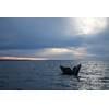
Just days before a team of researchers from Woods Hole Oceanographic Institution (WHOI) and National Taiwan University set out to conduct fieldwork in the East China Sea, Typhoon Morakot—one of the most destructive storms ever to hit Taiwan—made landfall on the island, causing widespread damage and drastically altering the flow of water along the nearby continental shelf. The typhoon, which struck in Aug. 2009, caused catastrophic damage in Taiwan, killing several hundred people and dropping up to 2 meters of rain in just 5 days in the mountains.
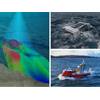
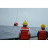
In their work to understand the strong currents over the continental shelf and slope in the East China Sea, the researchers used four ships for intensive sampling of the continental shelf and slope, and deployed several moorings and conducted high-resolution hydrographic surveys. But the timing of their research also enabled them to examine the impact of freshwater run-off from Typhoon Morakot on the continental shelf northeast of Taiwan, the upwelling and cooling that occurred over the continental shelf after the Typhoon, and the effect of Typhoon Morakot on the biogeochemistry and nutrient dynamics of the continental shelf.
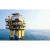
Although the East China Sea is home to some of the world’s most active fisheries and shipping lanes, the basic oceanography of the area is not yet well understood, says WHOI coastal oceanographer Glen Gawarkiewicz, one of the primary investigators for the program. “It’s a very difficult place to study—the currents in the region are extremely powerful, and are constantly shifting and changing, which makes it tough to predict how the ocean will behave there at any given time,” he notes. As a result, Gawarkiewicz says existing computer models of the area have a large degree of “uncertainty,” or margin of error.
The joint program, called “Quantifying, Predicting, and Exploiting Uncertainty” (QPE), is using data collected in the field to understand how uncertainty in computer models of the ocean near Taiwan changes in time and space. In the process, Gawarkiewicz hopes the QPE team will not only be able to improve the current oceanographic understanding of the East China Sea, but improve methods used to model similar currents around the world. Funding for the program was provided by the U.S. Office of Naval Research.
For more information, please visit www.whoi.edu