NOAA’s Lake Level Viewer Aids Great Lakes Community Planning
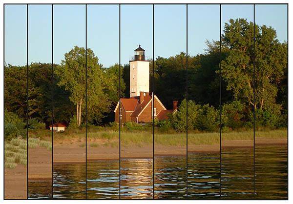
This visualization, using photo bars, shows impacts of rising lake levels at a set location. (Credit: Marty Drabic.)
Promotes community resilience through scenarios for land use, infrastructure.
A new NOAA online visualization and mapping tool, the Lake Level Viewer, will help communities along the U.S. Great Lakes plan for, and adapt to, climate change and changes in lake water levels.
The easy-to-use, interactive tool was developed by the National Ocean Service’s Office for Coastal Management as part of its Digital Coast initiative.
“The Lake Level Viewer provides planners and decision makers with visual lake level scenarios for rise and drop information before it happens,” said Jim Schwab, a certified planner and the manager of theHazards Planning Center for the American Planning Association. “Lake level scenarios can be incorporated into land use decisions, along with economic, social, and environmental considerations, to make wise investments in public infrastructure and develop livable, resilient communities.”
The viewer uses high-resolution elevation data, enabling users to display and visualize water levels associated with different lake level scenarios with a high degree of accuracy—ranging from zero to six feet above and below average lake level. Users can view elevation models, determine lake water depths at specific locations, examine data confidence, and view societal and economic impacts.
Rising or decreasing lake levels can affect commercial interests as well as shoreline habitats and structures. More than 4,900 miles of U.S. shoreline ring the Great Lakes, of which 3,800 miles are currently mapped on the Lake Level Viewer. The tool covers areas in Illinois, Indiana, Michigan, Minnesota, New York, Ohio, Pennsylvania, and Wisconsin.
Sharp fluctuations
Great Lakes water levels are continuously monitored by U.S. and Canadian agencies in the region through a binational partnership. NOAA’s Great Lakes Environmental Research Laboratory, the National Ocean Service’s Center for Operational Oceanographic Products and Services and the Canadian Hydrographic Service have been tracking Great Lakes water levels over a number of years. The annual rise and fall cycle of the Lakes’ water levels can be seen online for particular time periods beginning in 1917 via the Great Lakes Water Level Dashboard.
Over the past decade there has been a steady decline in Great Lakes levels. However, recent months have seen a dramatic reversal of that trend. With the exception of Lake Ontario, water levels in each of the Great Lakes rose between seven and 12 inches from summer 2013 to summer 2014. A heavy snow season, slow-melting ice, and a rainy spring contributed to the sharp increases.
“Rapid fluctuations like these can cause changes in the plans, and the expected profits, of industries like tourism and shipping,” said Doug Marcy, a hazards specialist and part of the team that developed the tool through the NOAA Office for Coastal Management. ”Even small increases and decreases can affect large land areas, especially on relatively flat shorelines.”
In light of these rapidly changing water levels, it is even more important to have a tool like the viewer to help communities visualize and plan for scenarios. Further geospatial analysis can be achieved by downloading digital elevation models, depth and confidence data, or accessing map services.