Scientists Collect Biodiversity Data in Argentina’s Submarine Canyons
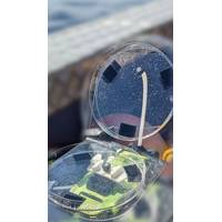
Scientists on an Argentinian-led expedition onboard Schmidt Ocean Institute’s R/V Falkor (too) deployed an array of technologies to collect the most robust data set available about how the major Malvinas ocean current interacts with submarine canyons and influences Argentina’s renowned marine biodiversity. Their goal was to better understand the region’s plankton blooms, the basis of the food web that sustains the Argentinian fishing industry. These plankton blooms are so large that they can be observed from space. The expedition was led by Dr. Silvia Ines Romero of Argentina
New Study Shows Connection Between Whale Health and Respiratory Microbes
whale population.The study, Respiratory microbiomes reflect whale health, opens the door to effective ways to monitor and protect the critically endangered North Atlantic right whale, whose population has dwindled to fewer than 400 individuals.Between 2016 and 2024, researchers from the Woods Hole Oceanographic Institution (WHOI), University of St Andrews, New England Aquarium, SR³, and Whale and Dolphin Conservation collected 103 respiratory samples from 85 North Atlantic right whales using drones. The researchers found that the microbial matter whales exhale through their blowholes carries
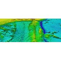
Raymarine Collaborates with Seabed 2030 Project to Advance Seabed Mapping
to promote cross sector collaboration to overcome the obstacles of deep ocean discovery.Launched in 2017, Seabed 2030 is a collaborative effort between The Nippon Foundation and GEBCO (General Bathymetric Chart of the Oceans), and is an officially endorsed program of the United Nations Decade of Ocean Science for Sustainable Development. The project aims to compile all available bathymetric data into a freely accessible map of the global seafloor, supporting marine conservation, climate modeling, tsunami forecasting, and sustainable ocean resource management.As part of this collaboration, Raymarine
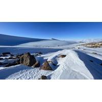
Scientists Discover Six Million Year Old Ice in Antarctica, Offers Unprecedented Window into a Warmer Earth
A team of researchers, including those from Woods Hole Oceanographic Institution (WHOI), has discovered the oldest directly dated ice and air on the planet in the Allan Hills region of East Antarctica, according to a new study published in the Proceedings of the National Academy of Sciences.A 6-million-year-old ice sample—the oldest sample from Allan Hills dated by researchers—provides an unprecedented window into Earth’s past climate, where abundant geological evidence indicates much warmer temperatures and higher sea levels compared to today.The research was led by Sarah Shackleton
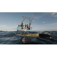
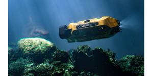
Redwing Glider Successfully Launched in Global Ocean Mission
Teledyne Marine has successfully launched the Slocum Sentinel glider, ‘Redwing’, into the Atlantic Ocean on Saturday, Oct. 11, approximately 43 miles southeast of Woods Hole, Mass. The launch, which is a collaboration with Rutgers University, took place aboard the Ocean Researcher, a 41-foot research vessel under clear skies and one- to three-foot seas.The Teledyne Marine team on board included Shea Quinn, Sentinel Mission Project Lead; Cordie Goodrich, Sentinel Mission Lead Pilot; and Sal Fricano, Glider Applications Engineer and Pilot.Redwing is embarking on the five-year Sentinel Mission

World Maritime Day Parallel Event 2025 Held in Dubai
Ministry of Energy and Infrastructure in collaboration with the International Maritime Organization (IMO).The event combined a maritime exhibition showcasing innovations in sustainable shipping, with a series of five panel discussions over two days, featuring experts and policy makers:Panel 1: Our Ocean, Our Obligation, Our Opportunity underscored the links between ocean health, prosperity and governance, while highlighting opportunities in the blue economy and the importance of ocean literacy and youth engagement.Panel 2: Decarbonization and climate change examined pathways to net-zero
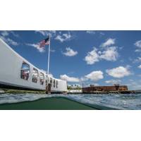
Oil Leaking from USS Arizona Could Provide Guidance for Thousands of WWII Shipwrecks
published in Marine Pollution Bulletin shows that oil is still seeping from the wreck of the USS Arizona, more than 80 years after its sinking at Pearl Harbor. The study focuses on samples collected by the National Park Service in 2016 and 2018.Researchers, led by the University of Houston and Woods Hole Oceanographic Institution (WHOI), analyzed oil samples collected from multiple leak points on the sunken battleship, using advanced molecular fingerprinting techniques. The results confirm the oil is a heavy fuel oil refined from California crude, consistent with U.S. Navy fueling practices in the early

Schmidt Sciences Awards $45M to Carbon Cycle Research
on immense amounts of hard-to-measure data, large uncertainties remain in the understanding of how carbon dioxide moves through the Earth at both the regional and continental scale. VICC aims to more accurately capture the carbon cycle—the global movement of carbon dioxide between the atmosphere, ocean, plants and soils.The four teams of international university researchers will collect high-resolution data needed to generate climate projections and, ultimately, inform the most significant decisions facing the planet. They will leverage AI and machine learning to develop new observations and model
NOAA and Partners Deploy C-Star USVs to Collect Hurricane Data
is the latest effort by NOAA to advance data collection to improve hurricane research and forecasting.Two additional C-Stars will be stored in Gulfport, Mississippi, and will be ready for launch ahead of actively developing storms in the Gulf this fall.“Understanding weather conditions where the ocean surface meets the lower atmosphere is key to predicting hurricane intensity,” said Greg Foltz, oceanographer for NOAA’s Atlantic Oceanographic and Meteorological Laboratory (AOML). “If these miniature uncrewed surface vehicles prove reliable, they could become a critical piece of