EOMAP Contracted for Shallow Water Bathymetry


-
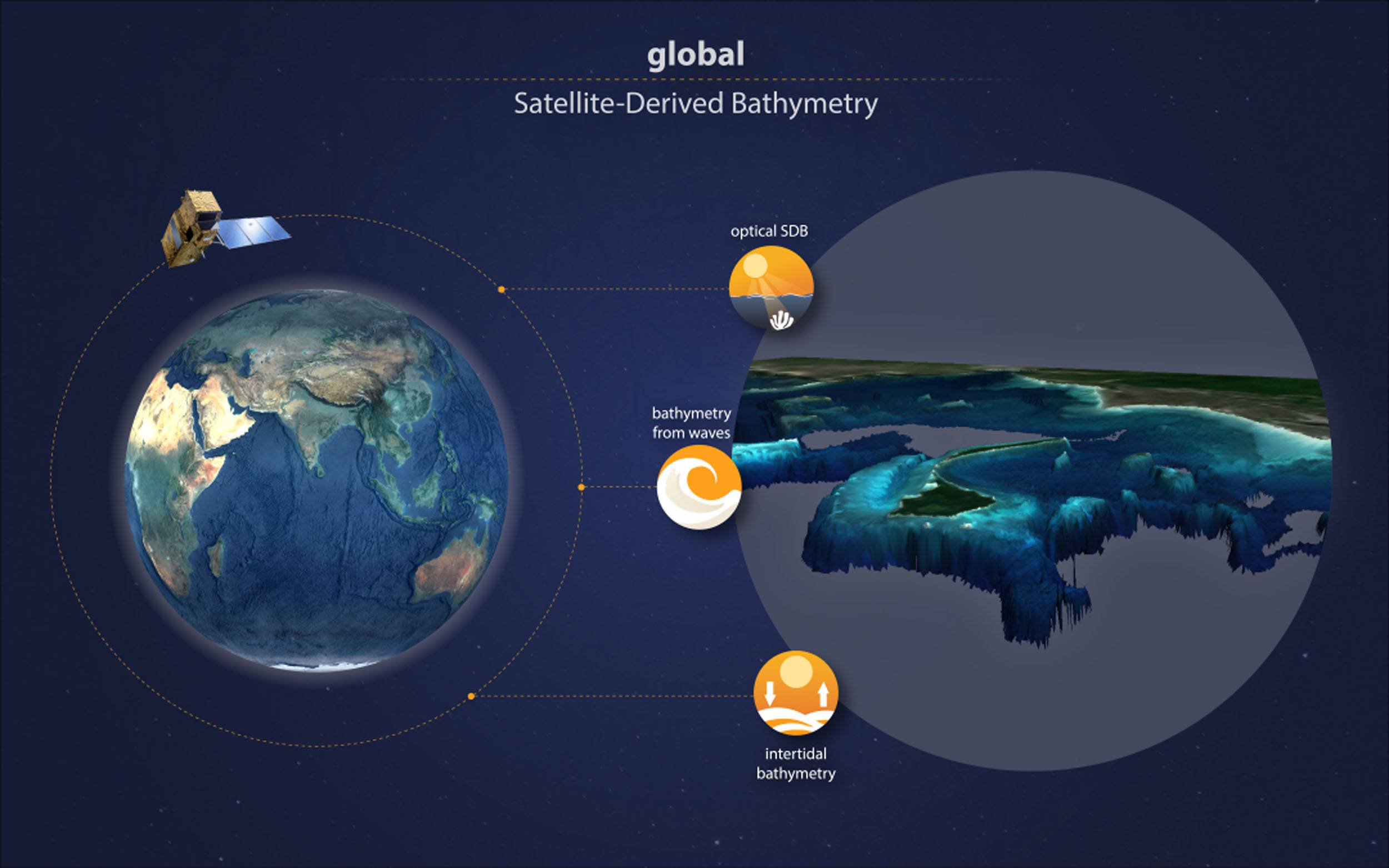
 Infographic global satellite-derived bathymetry - an MOi project lead by EOMAPSeefeld, Image courtesy EOMAP
-
 Angélique Melet – Oceanographer at MOi. Image courtesy EOMAP
-
 “By integrating our trusted water level modelling with an analysis of the comprehensive Sentinel-2 data archive, we’re pioneering global solutions for quality-assessed intertidal bathymetric data. This approach addresses the ever-growing need for consistent coastal mapping in both data scarce and rich environments, providing crucial information to several applications like morpho-dynamic modelling,” said Etiënne Kras, an advisor / researcher in Resilient Ports & Coasts at Deltares. Image courtes


Coastal zones, at the interface of land and ocean, are of tremendous social, economic, and ecological value: About 40% of the world population is currently living within 100 km of the coast, with three quarters of all large cities being situated along coastlines.
Together with its partners Deltares and GGS Geo Consultancy (GGSgc), team lead EOMAP will now provide global coastal bathymetric data to fill this knowledge gap. Bathymetry, the underwater topography, is a key environmental parameter for a wide range of coastal applications, such as modelling and hazard assessment, seafloor classification, and quantifying habitat loss or carbon storage capacity.
The Copernicus Marine implemented by Mercator Ocean International (MOi) prioritizes the development of a coastal extension to the service. The satellite-derived bathymetry products to be developed for the Copernicus Marine Service starting with this contract will complement activities of EMODnet bathymetry. This is in line with the high-level agreement between the EU DG DEFIS and DG MARE for the coordination of activities between Copernicus Marine and EMODnet. “For knowledge-based decision-making on coastal issues, reliable open data that describe, monitor and forecast the environment is key. Nearshore bathymetry datasets as delivered by this project strengthen the Copernicus Marine Service portfolio, as it will now provide better monitoring of coastal zones, maximizing the use of Copernicus Sentinel missions; this is one of the top priorities for the Copernicus Marine Evolution.” says Angélique Melet, an oceanographer at MOi. “The project will combine multiple techniques to provide global shallow water bathymetry from satellite data. Our focus will be on optical bathymetry and that derived from wave kinematics,” said Mona Reithmeier, project manager at EOMAP. Image courtesy EOMAPThis will be complemented by intertidal bathymetry from the globally recognised Dutch knowledge institute for water and the subsurface, Deltares, and its established modelling know-how: “By integrating our trusted water level modelling with an analysis of the comprehensive Sentinel-2 data archive, we’re pioneering global solutions for quality-assessed intertidal bathymetric data. This approach addresses the ever-growing need for consistent coastal mapping in both data scarce and rich environments, providing crucial information to several applications like morpho-dynamic modelling,” said Etiënne Kras, an advisor / researcher in Resilient Ports & Coasts at Deltares.
In view of the global scale of the project, George Spoelstra, the managing director of GGSgc, will add his international experience as an expert in marine cartography and bathymetry: “Working on a global dataset comes with several challenges: It not only requires scaling-up of data processing routines, but also merging different datasets, quality and coordinate systems. Luckily, we can build on our experience from the
European EMODnet Bathymetry project which – in return – will benefit from the project results.”