Marine Technology Reporter Blogs - geophysical
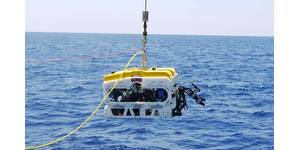
MMT Upgrades ROTVs for Offshore Surveys

MMT is a Swedish marine survey company offering turnkey services, including two remotely operated towed vehicles (ROTV) equipped with various survey equipment for complete geophysical surveys. MMT has now upgraded the systems to be fully equipped with side scan sonars and sub bottom profilers, in addition to multi-beam echo sounders, inertial navigation system and doppler velocity log. This means a complete geophysical survey can be done from this platform in a speed of 6 knots and down to a water depth of 400 meters. The advantage of the ROTV is that it is a powerful tool for accurate line keeping during a survey. The upgrades system enhances the control of the tow-fish and allows both a constant altitude above the seafloor as well as maintaining the planned survey lines.
OGX chooses DecisionSpace Desktop Software
It was recently announced that all of OGX´s geophysical and geological software applications will be moved to Landmark´s DecisionSpace Desktop, which is a Halliburton owned company. "The integration of workflows and data such as rock, logs and seismic across domains in the DecisionSpace Desktop allows us to work more efficiently as we explore for hydrocarbons, improve our asset knowledge, and reduce our exploration risk.", said Marcos Amaral, OGX´s Executive Manager for New Technologies. "DecisionSpace Desktop's unique approach to reservoir description, known as Dynamic GeoModeling, is a no compromise, unified and dynamically updated interpretation and modeling system," said Gene Minnich, vice president of Landmark Software and Services.