MMT Upgrades ROTVs for Offshore Surveys


-
 equipment map
-
 x Wooden sculptures
-
 x Mohican ROV
-
 GS gno x Small
-
 MMT Reach Subsea Establish JV Within Offshore Survey Operations
-
 Norway MMT Conducts Seabed Survey for BKK Kollsnes Mongstad Project
-
 1a
1a
-
 MMT to Survey UK Norway HVDC Cable Route
-
 mmt cpt


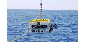
MMT is a Swedish marine survey company offering turnkey services, including two remotely operated towed vehicles (ROTV) equipped with various survey equipment for complete geophysical surveys. MMT has now upgraded the systems to be fully equipped with side scan sonars and sub bottom profilers, in addition to multi-beam echo sounders, inertial navigation system and doppler velocity log.
This means a complete geophysical survey can be done from this platform in a speed of 6 knots and down to a water depth of 400 meters. The advantage of the ROTV is that it is a powerful tool for accurate line keeping during a survey. The upgrades system enhances the control of the tow-fish and allows both a constant altitude above the seafloor as well as maintaining the planned survey lines. The ROTV also improves the actual direction of the tow-fish unit, which greatly improves the data quality of the side scan sonar.
The company headquarters is located at Nya Varvet, at the entrance to the port of Gothenburg. Here the management and processing departments provide high-quality ultra-modern CAD/GIS processing for projects, as well as logistic support for ongoing projects. The company employs 200 people with various specialties in the field of marine survey work. MMT has proven capability in performing a variety of survey tasks worldwide with the focus on bathymetry, geophysics, geo-technics and seabed inspections. Typical tasks are bathymetrical area surveys for chart production and route surveys for telecom fiber optic cables, power cables and pipelines. Geophysical site surveys are performed for various offshore infrastructures and for archaeological projects, wreck identification and ammunition searches. Environmental mapping projects are performed in lakes, rivers and coastal areas as well as offshore in deep water.
The concept of using towed ROVs is not new, however the way they are being used by MMT makes them very efficient by adding an inertial navigation system while at the same time offering complete geophysical survey systems. It would undoubtedly be interesting for the company to further upgrade its systems in order to function in deeper waters down to 1000 meters and beyond.