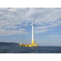
Saitec Tests Nature Inclusive Design Installations at Floating Wind Platform
Saitec Offshore Technologies, through DemoSATH Lab, is using its operating floating wind demonstrator as a real-scale testing ground to study environmental interactions, improve monitoring methods, and explore solutions that support coexistence with marine biodiversity.Following the successful deployment of biomimetic reef solutions on the submerged section of the platform, the company is now testing new methods to co-locate floating wind and aquaculture.The recent offshore operation marks a new step in DemoSATH Lab's biodiversity program and forms part of the AQUASATH Project, with the installation
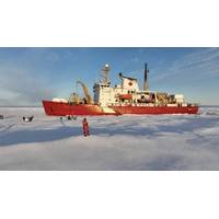
Multidisciplinary Scientific Expedition Sets Sail July 10 Aboard the CCGS Amundsen
ice mass in the Northern Hemisphere. Their work will help improve understanding of how glaciers melt affects Arctic marine ecosystems and productivity, northern communities and global sea levels. These teams will return aboard the Amundsen in November to study how Arctic sea ice forms and evolves during ocean freeze-up, a critical but understudied period that influences heat and gas exchanges across the air-sea interface, ecological cycles at the onset of the polar night, and the predictability of changing ice conditions.Three major research programs will join forces in September to investigate how glacier
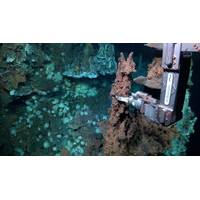
Subsea Hydrothermal Vents Discovered in the Doldrums Region
Scientists on a 35-day research expedition onboard Schmidt Ocean Institute’s R/V Falkor (too) discovered two new hydrothermal vent fields in a region of the middle of the Atlantic Ocean known as the Doldrums Megatransform and Fracture Zone, which lies just north of the equator about 800 miles off the northeast coast of Brazil. This large, tectonically active system cuts across the world’s longest mountain chain, the Mid-Atlantic Ridge. While many hydrothermal vents have been found along the ridge, these are the first known vent fields to be discovered in and around the Doldrums system.
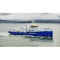
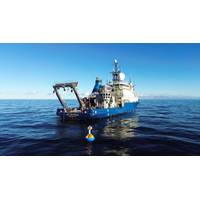
KONGSBERG Supplies Technology Suite for NIOZ RV Anna Weber-van Bosse
KONGSBERG has supplied a comprehensive package of advanced ocean science and navigation technologies for RV Anna Weber-van Bosse, the new ocean research vessel owned and operated by Royal Netherlands Institute for Sea Research (NIOZ).Christened on the island of Texel in early March, the 80-meter newbuild has been outfitted with a range of innovations including HiPAP acoustic positioning systems, EM304 and EM2040 multibeam echosounders, TOPAS sub-bottom profiling technology, advanced echosounders for water column observation, and Seapath inertial navigation systems.The solutions will deliver a vast
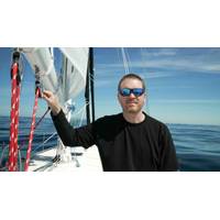
Explorer to Attempt Solo Unassisted Nonstop Circumnavigation of the Arctic Ocean
On June 25, solo sailor, explorer, researcher, and founder of the nonprofit Ocean Research Project, Matt Rutherford, will depart from Aasiaat, Greenland, where he will attempt the first-ever solo, nonstop, unassisted circumnavigation of the Arctic Ocean. His target finish is early October.The route covers more than 10,000 miles through three of the most hostile ocean environments on Earth: the North Atlantic, the Russian Arctic coast via the Northern Sea Route, and the Northwest Passage through the Canadian Arctic Archipelago. No one has completed this passage solo and nonstop. Until recently, no one
From Uncertainty to Advantage: WHOI Launches New Initiatives for Industry Partners
nearly a century of work. Our experience is grounded in data collection in the most demanding environments on Earth. We are now excited to make our oceanographic knowledge more accessible to the industry—let’s close one of the blue economy’s most persistent gaps by translating ocean science into decision-ready insight.WHOI OceanWorks: A Front Door for Industry CollaborationWHOI OceanWorks was launched in 2025 to serve as a front door for industry engagement, built on the recognition that much of the value embedded in ocean science and technology has yet to reach the point of use
PML: 20 Years of Data Shows Declining Ocean Productivity Around UK
A new study by scientists at Plymouth Marine Laboratory (PML) has revealed a significant long-term decline in ocean productivity across large parts of the north-east Atlantic. This raises concerns about the future health of marine food webs, fisheries and the ocean’s ability to absorb and sequester carbon dioxide.Using more than two decades of satellite observations, researchers analyzed changes in microalgae net primary production, the process by which microscopic marine plants convert sunlight and carbon dioxide into organic matter, which forms the foundation of marine ecosystems.The study
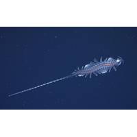
Schmidt Ocean Institute Research Team Discovers 31 New Species
areas on Earth to explore because of its inaccessibility and immense volume. The Sasakawa Peace Foundation’s Ocean Shot Research Grant Program funded two midwater programs that made this work possible, one based at the University of Western Australia and the other at Bigelow Laboratory for Ocean Sciences, USA.The technologies used to identify new species were a combination of imaging systems and genetic analyses. The imaging systems included the DeepPIV (particle image velocimetry) and EyeRIS (remote imaging system) instruments, developed by the Bioinspiration Lab at MBARI (Monterey Bay
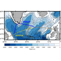
SAMS Oceanographic Array Will Aid Atlantic Meridional Overturning Circulation Observations
Ellett Line time series, as well as Argo floats drifting in the Atlantic. Data from the new array, which stretches from Scotland to Canada, also pre-dates OSNAP (established in 2014) by 10 years, giving observations from 2004-2024.The findings have been published in a new paper in the journal Ocean Science.Oceanographers across the world have long hypothesized that the AMOC could be weakening because of climate change, a view partly supported by a sub-tropical array of moorings known as RAPID, which has been in place since 2004. Because AMOC transports heat northwards from the tropics, a weakening


