
De Keukelaere Wins IADC "Young Author Award"
on the location of the drone, a projected true color image captured by the camera and the position of neighboring boats through Automatic Identification System (AIS). Thanks to this information it is easy to adapt flight missions according to the situation. The drone data were processed with dedicated software into turbidity maps. This independently from in-situ observations. Water samples, collected simultaneously with drone flights were used for the validation of the derived products

PulSAR: New SSS for SAR Operations
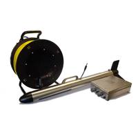
for the given survey task. PulSAR is battery or mains powered, using 24 VDC or 110/230 VAC. It has an integrated GPS system that provides positioning information with SBAS differential corrections and an external positioning system can be connected via a serial port. The system is delivered with a dedicated software package to be run on a laptop computer connected via Ethernet to the deck unit. It allows the user to plan and conduct the survey and acquire sonar data with embedded positioning information. www.km.kongsberg.com (As published in the March 2015 edition of Marine Technology Reporter
New Side Scan Sonar for SAR Operations
.” PulSAR is battery or mains powered, using 24 VDC or 110/230 VAC. It has an integrated GPS system that provides positioning information with SBAS differential corrections and an external positioning system can be connected via a serial port. The system is delivered with a dedicated software package to be run on a laptop computer connected via Ethernet to the deck unit. It allows the user to plan and conduct the survey and acquire sonar data with embedded positioning information. The data can be processed, visualized and interpreted in the software package and exported in industry


